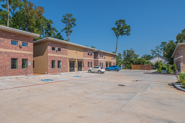
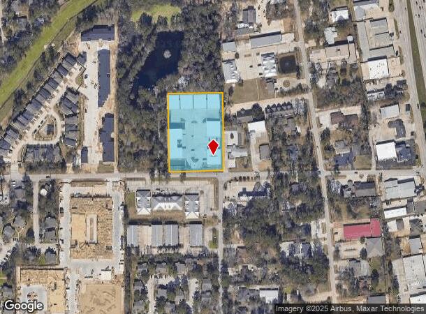
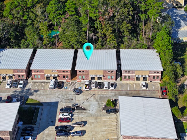
Property Record
350 Nursery Rd, Spring, TX 77380
NEARBY LISTINGS FOR SALE OR LEASE
Property Detail
350 Nursery Rd
Houston-The Woodlands-Sugar Land, TX
Grogans Gate Professional Center
5510-00-00101
S551000 - GROGANS GATE PROFESSIONAL CENTER, BLDG 1 UNIT 1101
Commercialnec
Montgomery
X
Texas
2024
0.08 AC
2025
The Woodlands
691601
Houston
1,500 SF
DEMOGRAPHICS near 350 Nursery Rd
1 Mile
3 Mile
5 Mile
2024 Total Population
13,018
67,446
182,627
2029 Population
15,867
81,964
214,800
Pop Growth 2024-2029
+ 21.89%
+ 21.53%
+ 17.62%
Average Age
37
39
38
2024 Total Households
5,167
27,492
67,921
HH Growth 2024-2029
+ 22.06%
+ 21.98%
+ 18.19%
Median Household Inc
$64,658
$83,330
$99,869
Avg Household Size
2.50
2.40
2.60
2024 Avg HH Vehicles
2.00
2.00
2.00
Median Home Value
$283,824
$273,580
$297,436
Median Year Built
1988
1997
2002
Nearby Places
Map Layers
Map Styles
 Street
 Aerial
- Restaurants
- Banks
- Shops
- Fitness
- Groceries
PUBLIC TRANSPORTATION
AIRPORT
George Bush Intcntl/Houston
DRIVE
WALK
Distance
George Bush Intcntl/Houston
24 min
19.5 mi
Freight Ports
Port of Houston
DRIVE
WALK
Distance
Port of Houston
47 min
35.2 mi
SALE & LEASE HISTORY
LISTING DATE
SALE/LEASE

Sep 21, 2024
For Sale
Sep 05, 2024
For Lease
Jun 01, 2023
For Lease
Feb 04, 2025
For Lease
Aug 30, 2018
For Sale
Aug 30, 2018
For Lease
Nearby Properties
Address
Land Use
TOTAL SIZE
Lot Size
Zoning
Address
Land Use
TOTAL SIZE
Lot Size
Zoning
6,576,138 SF
186.74 AC
Address
Land Use
TOTAL SIZE
Lot Size
Zoning
1,416,950 SF
21.80 AC
Address
Land Use
TOTAL SIZE
Lot Size
Zoning
1,673,574 SF
5.10 AC
Address
Land Use
TOTAL SIZE
Lot Size
Zoning
855,268 SF
31.65 AC
6
Address
Land Use
TOTAL SIZE
Lot Size
Zoning
718,313 SF
33.62 AC
Address
Land Use
TOTAL SIZE
Lot Size
Zoning
709,789 SF
3.04 AC
Address
Land Use
TOTAL SIZE
Lot Size
Zoning
1,053,284 SF
2.25 AC
Address
Land Use
TOTAL SIZE
Lot Size
Zoning
707,184 SF
3.48 AC
Address
Land Use
TOTAL SIZE
Lot Size
Zoning
974,064 SF
11.79 AC
Address
Land Use
TOTAL SIZE
Lot Size
Zoning
565,113 SF
4.52 AC
Address
Land Use
TOTAL SIZE
Lot Size
Zoning
469,813 SF
3.16 AC
Address
Land Use
TOTAL SIZE
Lot Size
Zoning
225,149 SF
1.07 AC
Address
Land Use
TOTAL SIZE
Lot Size
Zoning
670,665 SF
6.70 AC
Address
Land Use
TOTAL SIZE
Lot Size
Zoning
571,041 SF
4.82 AC
Address
Land Use
TOTAL SIZE
Lot Size
Zoning
438,062 SF
4.54 AC
Address
Land Use
TOTAL SIZE
Lot Size
Zoning
1,132,062 SF
3.31 AC
Address
Land Use
TOTAL SIZE
Lot Size
Zoning
457,883 SF
3.74 AC
Address
Land Use
TOTAL SIZE
Lot Size
Zoning
327,377 SF
24.02 AC
6
Address
Land Use
TOTAL SIZE
Lot Size
Zoning
473,060 SF
10.07 AC
Address
Land Use
TOTAL SIZE
Lot Size
Zoning
327,018 SF
21.91 AC
6
Address
Land Use
TOTAL SIZE
Lot Size
Zoning
368,000 SF
8.65 AC
Address
Land Use
TOTAL SIZE
Lot Size
Zoning
467,928 SF
6 AC
Address
Land Use
TOTAL SIZE
Lot Size
Zoning
296,094 SF
10.19 AC
Address
Land Use
TOTAL SIZE
Lot Size
Zoning
514,121 SF
2.01 AC
Address
Land Use
TOTAL SIZE
Lot Size
Zoning
279,413 SF
12.45 AC
6
Address
Land Use
TOTAL SIZE
Lot Size
Zoning
336,730 SF
2.41 AC
Address
Land Use
TOTAL SIZE
Lot Size
Zoning
383,484 SF
4.67 AC
Address
Land Use
TOTAL SIZE
Lot Size
Zoning
246,719 SF
1.25 AC
Address
Land Use
TOTAL SIZE
Lot Size
Zoning
325,294 SF
21.81 AC
6
Address
Land Use
TOTAL SIZE
Lot Size
Zoning
162,976 SF
1.04 AC
The World's #1 Commercial Real Estate Marketplace
Connect with us
© 2025 CoStar Group
The information above has been obtained from sources believed reliable. While we do not doubt its accuracy we have not verified it and make no guarantee, warranty or representation about it. It is your responsibility to independently confirm its accuracy and completeness. Any projections, opinions, assumptions, or estimates used are for example only and do not represent the current or future performance of the property. The value of this transaction to you depends on tax and other factors which should be evaluated by your tax, financial, and legal advisors. You and your advisors should conduct a careful, independent investigation of the property to determine to your satisfaction the suitability of the property for your needs.