Property Record
350 Prin-Hightstown R Rd, West Windsor, NJ 08550
NEARBY LISTINGS FOR SALE OR LEASE
Property Detail
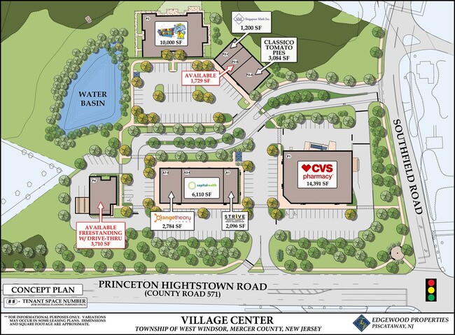
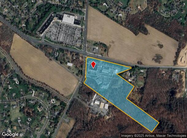
350 Prin-Hightstown R Rd
Trenton, NJ
ADDITIONAL LOTS: SOME VACANT UNITS
13-00028-0000-00001-01
Mercer
Vacantlandnec
New Jersey
X
1.1
34021C0162F
16.43 AC
2024
Trenton
2025
Northern New Jersey
004316
DEMOGRAPHICS near 350 Prin-Hightstown R Rd
1 Mile
3 Mile
5 Mile
2024 Total Population
2,500
42,482
98,893
2029 Population
2,450
41,710
98,004
Pop Growth 2024-2029
(2.00%)
(1.82%)
(0.90%)
Average Age
45
41
40
2024 Total Households
848
16,066
36,423
HH Growth 2024-2029
(2.12%)
(1.95%)
(0.96%)
Median Household Inc
$220,296
$127,338
$127,426
Avg Household Size
2.90
2.60
2.60
2024 Avg HH Vehicles
2.00
2.00
2.00
Median Home Value
$693,032
$482,712
$513,787
Median Year Built
1988
1981
1984
Nearby Places
- Restaurants
- Banks
- Shops
- Fitness
- Groceries
PUBLIC TRANSPORTATION
COMMUTER RAIL
Princeton Junction (Northeast Corridor Line - NJ Transit Commuter Rail (NJ Transit), Princeton Branch - NJ Transit Commuter Rail (NJ Transit))
DRIVE
WALK
Distance
Princeton Junction (Northeast Corridor Line - NJ Transit Commuter Rail (NJ Transit), Princeton Branch - NJ Transit Commuter Rail (NJ Transit))
7 min
3.7 mi
Princeton (Princeton Branch - NJ Transit Commuter Rail (NJ Transit))
DRIVE
WALK
Distance
Princeton (Princeton Branch - NJ Transit Commuter Rail (NJ Transit))
12 min
6.3 mi
AIRPORT
Trenton Mercer
DRIVE
WALK
Distance
Trenton Mercer
27 min
17.8 mi
Freight Ports
New York Container Terminal
DRIVE
WALK
Distance
New York Container Terminal
53 min
38.2 mi
Nearby Properties
Address
Land Use
TOTAL SIZE
Lot Size
Zoning
Address
Land Use
TOTAL SIZE
Lot Size
Zoning
46.23 AC
PCD
Address
Land Use
TOTAL SIZE
Lot Size
Zoning
2,448 SF
59.55 AC
RO
Address
Land Use
TOTAL SIZE
Lot Size
Zoning
110.44 AC
OW
Address
Land Use
TOTAL SIZE
Lot Size
Zoning
89.76 AC
R100
Address
Land Use
TOTAL SIZE
Lot Size
Zoning
318,155 SF
36.28 AC
RO
Address
Land Use
TOTAL SIZE
Lot Size
Zoning
49.96 AC
R24
Address
Land Use
TOTAL SIZE
Lot Size
Zoning
33.96 AC
PCD
Address
Land Use
TOTAL SIZE
Lot Size
Zoning
567,798 SF
134.06 AC
RO
Address
Land Use
TOTAL SIZE
Lot Size
Zoning
3.74 AC
E
Address
Land Use
TOTAL SIZE
Lot Size
Zoning
186,785 SF
29.83 AC
HC
Address
Land Use
TOTAL SIZE
Lot Size
Zoning
243,700 SF
34.78 AC
HC
Address
Land Use
TOTAL SIZE
Lot Size
Zoning
38.95 AC
R100
Address
Land Use
TOTAL SIZE
Lot Size
Zoning
23.60 AC
R1
Address
Land Use
TOTAL SIZE
Lot Size
Zoning
161,588 SF
28 AC
RO
Address
Land Use
TOTAL SIZE
Lot Size
Zoning
30.47 AC
R100
Address
Land Use
TOTAL SIZE
Lot Size
Zoning
281,154 SF
39.34 AC
RO
Address
Land Use
TOTAL SIZE
Lot Size
Zoning
36.99 AC
R-1
Address
Land Use
TOTAL SIZE
Lot Size
Zoning
15.55 AC
B-2
Address
Land Use
TOTAL SIZE
Lot Size
Zoning
27.46 AC
ROM3
Address
Land Use
TOTAL SIZE
Lot Size
Zoning
153,230 SF
12.30 AC
HC
Address
Land Use
TOTAL SIZE
Lot Size
Zoning
26.65 AC
R-2
Address
Land Use
TOTAL SIZE
Lot Size
Zoning
107,069 SF
16.02 AC
HC
Address
Land Use
TOTAL SIZE
Lot Size
Zoning
21.81 AC
RO
Address
Land Use
TOTAL SIZE
Lot Size
Zoning
38.54 AC
OW
Address
Land Use
TOTAL SIZE
Lot Size
Zoning
147.40 AC
R&D
Address
Land Use
TOTAL SIZE
Lot Size
Zoning
224,512 SF
15.24 AC
RM
Address
Land Use
TOTAL SIZE
Lot Size
Zoning
67.71 AC
E
Address
Land Use
TOTAL SIZE
Lot Size
Zoning
5.61 AC
E
Address
Land Use
TOTAL SIZE
Lot Size
Zoning
14.10 AC
PRRC
Address
Land Use
TOTAL SIZE
Lot Size
Zoning
186,552 SF
10.10 AC
RM
The World's #1 Commercial Real Estate Marketplace
Connect with us
© 2025 CoStar Group
The information above has been obtained from sources believed reliable. While we do not doubt its accuracy we have not verified it and make no guarantee, warranty or representation about it. It is your responsibility to independently confirm its accuracy and completeness. Any projections, opinions, assumptions, or estimates used are for example only and do not represent the current or future performance of the property. The value of this transaction to you depends on tax and other factors which should be evaluated by your tax, financial, and legal advisors. You and your advisors should conduct a careful, independent investigation of the property to determine to your satisfaction the suitability of the property for your needs.