Property Record
350 S Main St, Pataskala, OH 43062
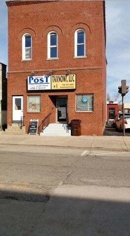

Property Detail
350 S Main St
Columbus, OH
LOT 62 PT & 64 PT RICHARD CONINES ADD
064-307770-00.000
Licking
Officebuilding
Ohio
B and X Area of moderate flood hazard, usually the area between the limits of the 100-year and 500-year floods.
62
2025
0.09 AC
2025
Licking County
756801
Columbus
3,516 SF
NEARBY LISTINGS FOR SALE OR LEASE
-
-
View all Pataskala listings for lease on LoopNet.com
DEMOGRAPHICS near 350 S Main St
1 mile
3 mile
5 mile
2025 Total Population
6,189
20,746
39,134
2030 Population
6,391
21,353
40,224
Pop Growth 2025-2030
+ 3.26%
+ 2.93%
+ 2.79%
Average Age
40
40
40
2025 Total Households
2,374
7,557
13,971
HH Growth 2025-2030
+ 3.24%
+ 2.94%
+ 2.78%
Median Household Inc
$77,059
$96,132
$100,905
Avg Household Size
2.50
2.70
2.70
2025 Avg HH Vehicles
2.00
2.00
2.00
Median Home Value
$303,729
$324,735
$317,834
Median Year Built
1988
1994
1993
Nearby Places
Map Layers
Map Styles
 Street
 Aerial
Layers
 Traffic
 Biking
Places
Listings with unknown addresses are not visible on the map
- Restaurants
- Banks
- Shops
- Fitness
- Groceries
PUBLIC TRANSPORTATION
AIRPORT
John Glenn Columbus International
Drive
Walk
Distance
John Glenn Columbus International
25 min
14.8 mi
Rickenbacker International
Drive
Walk
Distance
Rickenbacker International
32 min
23.1 mi
SALE & LEASE HISTORY
LISTING DATE
SALE/LEASE

Sep 26, 2016
For Lease
Nearby Properties
Address
Land Use
TOTAL SIZE
Lot Size
Zoning
Address
Land Use
TOTAL SIZE
Lot Size
Zoning
1,430,005 SF
101.26 AC
Address
Land Use
TOTAL SIZE
Lot Size
Zoning
946,400 SF
80.92 AC
Address
Land Use
TOTAL SIZE
Lot Size
Zoning
1,091,997 SF
49.37 AC
Address
Land Use
TOTAL SIZE
Lot Size
Zoning
437,569 SF
33 AC
Address
Land Use
TOTAL SIZE
Lot Size
Zoning
179.65 AC
Address
Land Use
TOTAL SIZE
Lot Size
Zoning
73,671 SF
80.57 AC
Address
Land Use
TOTAL SIZE
Lot Size
Zoning
47.69 AC
Address
Land Use
TOTAL SIZE
Lot Size
Zoning
89.41 AC
Address
Land Use
TOTAL SIZE
Lot Size
Zoning
2,436 SF
16.52 AC
Address
Land Use
TOTAL SIZE
Lot Size
Zoning
76,316 SF
20.34 AC
Address
Land Use
TOTAL SIZE
Lot Size
Zoning
9,408 SF
12.53 AC
Address
Land Use
TOTAL SIZE
Lot Size
Zoning
78,136 SF
7.46 AC
Address
Land Use
TOTAL SIZE
Lot Size
Zoning
53,202 SF
38.44 AC
Address
Land Use
TOTAL SIZE
Lot Size
Zoning
1,862 SF
105.97 AC
Address
Land Use
TOTAL SIZE
Lot Size
Zoning
9,600 SF
6.36 AC
Address
Land Use
TOTAL SIZE
Lot Size
Zoning
54,972 SF
15 AC
Address
Land Use
TOTAL SIZE
Lot Size
Zoning
21,906 SF
38.04 AC
Address
Land Use
TOTAL SIZE
Lot Size
Zoning
6,872 SF
10 AC
Address
Land Use
TOTAL SIZE
Lot Size
Zoning
84,861 SF
8.78 AC
Address
Land Use
TOTAL SIZE
Lot Size
Zoning
5,316 SF
6.83 AC
Address
Land Use
TOTAL SIZE
Lot Size
Zoning
1,649 SF
111.77 AC
Address
Land Use
TOTAL SIZE
Lot Size
Zoning
75,680 SF
20 AC
Address
Land Use
TOTAL SIZE
Lot Size
Zoning
51,200 SF
27.71 AC
Address
Land Use
TOTAL SIZE
Lot Size
Zoning
12,077 SF
43.63 AC
Address
Land Use
TOTAL SIZE
Lot Size
Zoning
89,569 SF
8.12 AC
Address
Land Use
TOTAL SIZE
Lot Size
Zoning
98.30 AC
Address
Land Use
TOTAL SIZE
Lot Size
Zoning
1,260 SF
64.76 AC
Address
Land Use
TOTAL SIZE
Lot Size
Zoning
2,448 SF
55.36 AC
Address
Land Use
TOTAL SIZE
Lot Size
Zoning
60.54 AC
Address
Land Use
TOTAL SIZE
Lot Size
Zoning
36,180 SF
7.15 AC
The World's #1 Commercial Real Estate Marketplace
Connect with us
© 2026 CoStar Group
The information above has been obtained from sources believed reliable. While we do not doubt its accuracy we have not verified it and make no guarantee, warranty or representation about it. It is your responsibility to independently confirm its accuracy and completeness. Any projections, opinions, assumptions, or estimates used are for example only and do not represent the current or future performance of the property. The value of this transaction to you depends on tax and other factors which should be evaluated by your tax, financial, and legal advisors. You and your advisors should conduct a careful, independent investigation of the property to determine to your satisfaction the suitability of the property for your needs.