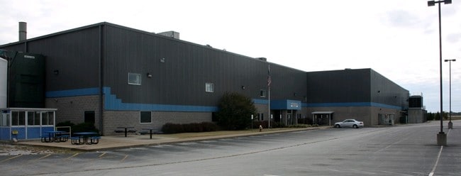
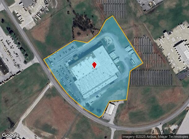
Property Record
350 Scottys Way, Bowling Green, KY 42101
NEARBY LISTINGS FOR SALE OR LEASE
Property Detail
350 Scottys Way
062A-70-005H
Scottys Indust Park Sub
Manufacturinglight
Warren
X
Kentucky
21061C0225B
5-8
2025
12.31 AC
2025
Bowling Green Area
011701
Other Market Areas
168,187 SF
Bowling Green, KY
DEMOGRAPHICS near 350 Scottys Way
1 Mile
3 Mile
5 Mile
2024 Total Population
1,959
9,230
18,098
2029 Population
2,223
10,270
20,095
Pop Growth 2024-2029
+ 13.48%
+ 11.27%
+ 11.03%
Average Age
33
35
37
2024 Total Households
793
3,583
7,149
HH Growth 2024-2029
+ 14.00%
+ 11.75%
+ 11.51%
Median Household Inc
$35,077
$52,291
$58,954
Avg Household Size
2.50
2.50
2.50
2024 Avg HH Vehicles
2.00
2.00
2.00
Median Home Value
$155,172
$162,582
$180,450
Median Year Built
1999
1995
1995
Nearby Places
Map Layers
Map Styles
 Street
 Aerial
- Restaurants
- Banks
- Shops
- Fitness
- Groceries
SALE & LEASE HISTORY
LISTING DATE
SALE/LEASE

Sep 23, 2016
For Sale
Nearby Properties
Address
Land Use
TOTAL SIZE
Lot Size
Zoning
Address
Land Use
TOTAL SIZE
Lot Size
Zoning
2,196,945 SF
212 AC
Address
Land Use
TOTAL SIZE
Lot Size
Zoning
Address
Land Use
TOTAL SIZE
Lot Size
Zoning
167,354 SF
13.63 AC
Address
Land Use
TOTAL SIZE
Lot Size
Zoning
83,927 SF
13.82 AC
Address
Land Use
TOTAL SIZE
Lot Size
Zoning
78,750 SF
21.68 AC
Address
Land Use
TOTAL SIZE
Lot Size
Zoning
290,029 SF
17.48 AC
Address
Land Use
TOTAL SIZE
Lot Size
Zoning
Address
Land Use
TOTAL SIZE
Lot Size
Zoning
261,828 SF
28.24 AC
Address
Land Use
TOTAL SIZE
Lot Size
Zoning
648,325 SF
42.45 AC
Address
Land Use
TOTAL SIZE
Lot Size
Zoning
Address
Land Use
TOTAL SIZE
Lot Size
Zoning
30.49 AC
Address
Land Use
TOTAL SIZE
Lot Size
Zoning
273,600 SF
22.39 AC
Address
Land Use
TOTAL SIZE
Lot Size
Zoning
13,342 SF
189.40 AC
Address
Land Use
TOTAL SIZE
Lot Size
Zoning
108,000 SF
16.97 AC
Address
Land Use
TOTAL SIZE
Lot Size
Zoning
133,947 SF
13.03 AC
Address
Land Use
TOTAL SIZE
Lot Size
Zoning
Address
Land Use
TOTAL SIZE
Lot Size
Zoning
24,440 SF
5 AC
Address
Land Use
TOTAL SIZE
Lot Size
Zoning
170,932 SF
12.42 AC
Address
Land Use
TOTAL SIZE
Lot Size
Zoning
Address
Land Use
TOTAL SIZE
Lot Size
Zoning
168,414 SF
18.03 AC
Address
Land Use
TOTAL SIZE
Lot Size
Zoning
142,800 SF
13.10 AC
Address
Land Use
TOTAL SIZE
Lot Size
Zoning
145,624 SF
19.66 AC
Address
Land Use
TOTAL SIZE
Lot Size
Zoning
50,600 SF
8.02 AC
Address
Land Use
TOTAL SIZE
Lot Size
Zoning
123,096 SF
48.76 AC
Address
Land Use
TOTAL SIZE
Lot Size
Zoning
27,282 SF
2.11 AC
Address
Land Use
TOTAL SIZE
Lot Size
Zoning
3,750 SF
6.62 AC
Address
Land Use
TOTAL SIZE
Lot Size
Zoning
6,842 SF
5 AC
Address
Land Use
TOTAL SIZE
Lot Size
Zoning
8,010 SF
1.91 AC
Address
Land Use
TOTAL SIZE
Lot Size
Zoning
Address
Land Use
TOTAL SIZE
Lot Size
Zoning
60,000 SF
5.27 AC
The World's #1 Commercial Real Estate Marketplace
Connect with us
© 2025 CoStar Group
The information above has been obtained from sources believed reliable. While we do not doubt its accuracy we have not verified it and make no guarantee, warranty or representation about it. It is your responsibility to independently confirm its accuracy and completeness. Any projections, opinions, assumptions, or estimates used are for example only and do not represent the current or future performance of the property. The value of this transaction to you depends on tax and other factors which should be evaluated by your tax, financial, and legal advisors. You and your advisors should conduct a careful, independent investigation of the property to determine to your satisfaction the suitability of the property for your needs.