Property Record
350 Sycamore St, Holbrook, MA 02343


NEARBY LISTINGS FOR SALE OR LEASE
Property Detail
350 Sycamore St
HOLB-000029-000000-000031
Norfolk
Residentialacreage
Massachusetts
X
31--0
25021C0238F
31.80 AC
2025
Route 24
2025
Boston
421200
Boston-Cambridge-Newton, MA-NH
DEMOGRAPHICS near 350 Sycamore St
1 Mile
3 Mile
5 Mile
2024 Total Population
2,797
55,096
198,229
2029 Population
2,781
54,913
197,026
Pop Growth 2024-2029
(0.57%)
(0.33%)
(0.61%)
Average Age
42
42
41
2024 Total Households
1,010
21,085
75,208
HH Growth 2024-2029
(0.50%)
(0.35%)
(0.64%)
Median Household Inc
$101,268
$103,224
$91,007
Avg Household Size
2.70
2.60
2.50
2024 Avg HH Vehicles
2.00
2.00
2.00
Median Home Value
$367,570
$453,201
$444,965
Median Year Built
1956
1962
1963
Nearby Places
Map Layers
Map Styles
 Street
 Aerial
- Restaurants
- Banks
- Shops
- Fitness
- Groceries
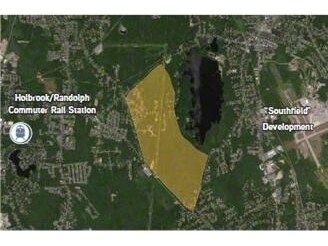
PUBLIC TRANSPORTATION
COMMUTER RAIL
Holbrook/Randolph (Middleborough/Lakeville Line - Massachusetts Bay Transportation Authority Commuter Rail (Purple Line))
DRIVE
WALK
Distance
Holbrook/Randolph (Middleborough/Lakeville Line - Massachusetts Bay Transportation Authority Commuter Rail (Purple Line))
5 min
2.7 mi
South Weymouth (Kingston/Plymouth Line - Massachusetts Bay Transportation Authority Commuter Rail (Purple Line))
DRIVE
WALK
Distance
South Weymouth (Kingston/Plymouth Line - Massachusetts Bay Transportation Authority Commuter Rail (Purple Line))
8 min
4.4 mi
AIRPORT
General Edward Lawrence Logan International
DRIVE
WALK
Distance
General Edward Lawrence Logan International
34 min
19.8 mi
Freight Ports
Port of Boston
DRIVE
WALK
Distance
Port of Boston
31 min
17.6 mi
Nearby Properties
Address
Land Use
TOTAL SIZE
Lot Size
Zoning
Address
Land Use
TOTAL SIZE
Lot Size
Zoning
40,396 SF
5.56 AC
100
Address
Land Use
TOTAL SIZE
Lot Size
Zoning
Address
Land Use
TOTAL SIZE
Lot Size
Zoning
235,150 SF
36.67 AC
R1
Address
Land Use
TOTAL SIZE
Lot Size
Zoning
3.65 AC
100
Address
Land Use
TOTAL SIZE
Lot Size
Zoning
168,801 SF
2.75 AC
100
Address
Land Use
TOTAL SIZE
Lot Size
Zoning
0.42 AC
A1
Address
Land Use
TOTAL SIZE
Lot Size
Zoning
144,377 SF
9.39 AC
Address
Land Use
TOTAL SIZE
Lot Size
Zoning
170,035 SF
1.64 AC
100
Address
Land Use
TOTAL SIZE
Lot Size
Zoning
80,226 SF
6.60 AC
RES
Address
Land Use
TOTAL SIZE
Lot Size
Zoning
147,069 SF
1.90 AC
Address
Land Use
TOTAL SIZE
Lot Size
Zoning
379,908 SF
15.14 AC
Address
Land Use
TOTAL SIZE
Lot Size
Zoning
8.54 AC
100
Address
Land Use
TOTAL SIZE
Lot Size
Zoning
76,223 SF
19.83 AC
B
Address
Land Use
TOTAL SIZE
Lot Size
Zoning
34.28 AC
85
Address
Land Use
TOTAL SIZE
Lot Size
Zoning
85,338 SF
1.85 AC
Address
Land Use
TOTAL SIZE
Lot Size
Zoning
10.83 AC
Address
Land Use
TOTAL SIZE
Lot Size
Zoning
14.52 AC
Address
Land Use
TOTAL SIZE
Lot Size
Zoning
1,452 SF
28.90 AC
R1C
Address
Land Use
TOTAL SIZE
Lot Size
Zoning
73,460 SF
1.16 AC
A2
Address
Land Use
TOTAL SIZE
Lot Size
Zoning
60,832 SF
1.89 AC
Address
Land Use
TOTAL SIZE
Lot Size
Zoning
60,832 SF
2.28 AC
Address
Land Use
TOTAL SIZE
Lot Size
Zoning
43.35 AC
Address
Land Use
TOTAL SIZE
Lot Size
Zoning
89,764 SF
6.77 AC
Address
Land Use
TOTAL SIZE
Lot Size
Zoning
2.64 AC
100
Address
Land Use
TOTAL SIZE
Lot Size
Zoning
137,765 SF
12.40 AC
Address
Land Use
TOTAL SIZE
Lot Size
Zoning
99,432 SF
10 AC
HBD
Address
Land Use
TOTAL SIZE
Lot Size
Zoning
12.17 AC
R4
Address
Land Use
TOTAL SIZE
Lot Size
Zoning
43,291 SF
3.32 AC
100
Address
Land Use
TOTAL SIZE
Lot Size
Zoning
40,421 SF
5.31 AC
I1
Address
Land Use
TOTAL SIZE
Lot Size
Zoning
5,330 SF
4.85 AC
RES
The World's #1 Commercial Real Estate Marketplace
Connect with us
© 2025 CoStar Group
The information above has been obtained from sources believed reliable. While we do not doubt its accuracy we have not verified it and make no guarantee, warranty or representation about it. It is your responsibility to independently confirm its accuracy and completeness. Any projections, opinions, assumptions, or estimates used are for example only and do not represent the current or future performance of the property. The value of this transaction to you depends on tax and other factors which should be evaluated by your tax, financial, and legal advisors. You and your advisors should conduct a careful, independent investigation of the property to determine to your satisfaction the suitability of the property for your needs.