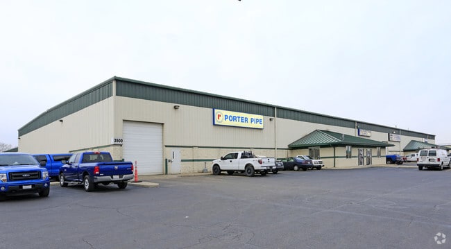
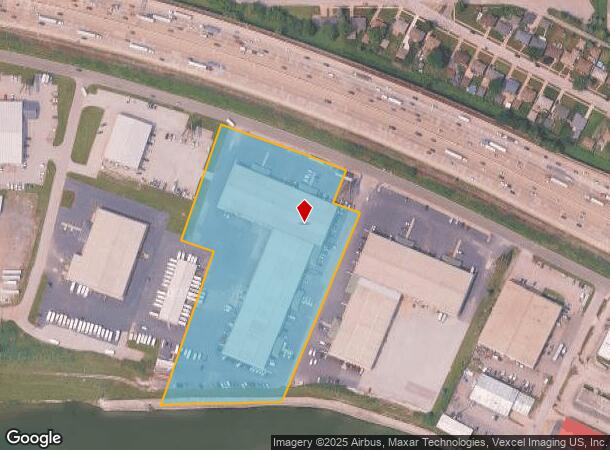
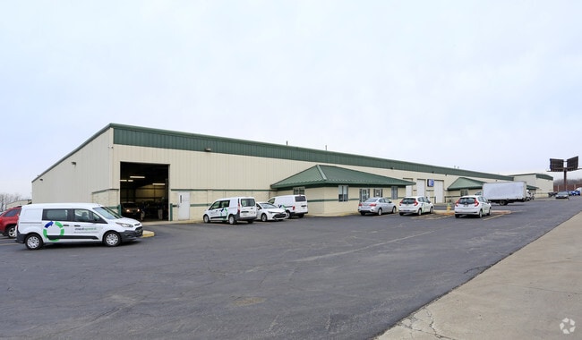
Property Record
3500 179Th St, Hammond, IN 46323
NEARBY LISTINGS FOR SALE OR LEASE
Property Detail
3500 179Th St
Chicago-Naperville-Elgin, IL-IN-WI
Merrimac Add Wly
45-07-15-326-002.000-023
MERRIMAC ADD WLY 1/2 LOT 2 EX. 100X85.01FT PARCEL
Warehouse
Lake
AE
Indiana
18089C0129E
2
2024
6.84 AC
2025
Indiana
021100
Chicago
97,755 SF
DEMOGRAPHICS near 3500 179Th St
1 Mile
3 Mile
5 Mile
2024 Total Population
7,679
78,243
193,524
2029 Population
7,609
78,019
193,044
Pop Growth 2024-2029
(0.91%)
(0.29%)
(0.25%)
Average Age
39
39
40
2024 Total Households
3,014
31,220
76,058
HH Growth 2024-2029
(0.93%)
(0.34%)
(0.27%)
Median Household Inc
$65,419
$58,586
$55,324
Avg Household Size
2.50
2.40
2.50
2024 Avg HH Vehicles
2.00
2.00
2.00
Median Home Value
$169,559
$168,894
$163,119
Median Year Built
1958
1960
1958
Nearby Places
Map Layers
Map Styles
 Street
 Aerial
- Restaurants
- Banks
- Shops
- Fitness
- Groceries
PUBLIC TRANSPORTATION
COMMUTER RAIL
Clark Road (Gary) Station (South Shore Line - Northern Indiana Commuter Transportation District (South Shore Line))
DRIVE
WALK
Distance
Clark Road (Gary) Station (South Shore Line - Northern Indiana Commuter Transportation District (South Shore Line))
11 min
6.6 mi
AIRPORT
Chicago Midway International
DRIVE
WALK
Distance
Chicago Midway International
45 min
29.7 mi
Freight Ports
Port Milwaukee
DRIVE
WALK
Distance
Port Milwaukee
148 min
116.2 mi
SALE & LEASE HISTORY
LISTING DATE
SALE/LEASE

Sep 24, 2016
For Lease
Jan 20, 2025
For Sale
Nearby Properties
Address
Land Use
TOTAL SIZE
Lot Size
Zoning
Address
Land Use
TOTAL SIZE
Lot Size
Zoning
233,023 SF
37.73 AC
Address
Land Use
TOTAL SIZE
Lot Size
Zoning
233,767 SF
37.03 AC
Address
Land Use
TOTAL SIZE
Lot Size
Zoning
509,210 SF
34.39 AC
Address
Land Use
TOTAL SIZE
Lot Size
Zoning
133,120 SF
32.04 AC
Address
Land Use
TOTAL SIZE
Lot Size
Zoning
240,900 SF
10.62 AC
Address
Land Use
TOTAL SIZE
Lot Size
Zoning
394,442 SF
16.83 AC
Address
Land Use
TOTAL SIZE
Lot Size
Zoning
254,500 SF
30.07 AC
Address
Land Use
TOTAL SIZE
Lot Size
Zoning
153,073 SF
4.88 AC
Address
Land Use
TOTAL SIZE
Lot Size
Zoning
77,091 SF
2.08 AC
Address
Land Use
TOTAL SIZE
Lot Size
Zoning
217,104 SF
10.45 AC
Address
Land Use
TOTAL SIZE
Lot Size
Zoning
79,169 SF
2.76 AC
Address
Land Use
TOTAL SIZE
Lot Size
Zoning
105,000 SF
2.90 AC
Address
Land Use
TOTAL SIZE
Lot Size
Zoning
189,392 SF
23.77 AC
Address
Land Use
TOTAL SIZE
Lot Size
Zoning
113,381 SF
9.31 AC
Address
Land Use
TOTAL SIZE
Lot Size
Zoning
527,227 SF
33.52 AC
R33
Address
Land Use
TOTAL SIZE
Lot Size
Zoning
100,000 SF
7.29 AC
R3
Address
Land Use
TOTAL SIZE
Lot Size
Zoning
167,108 SF
10.18 AC
Address
Land Use
TOTAL SIZE
Lot Size
Zoning
786,811 SF
37.23 AC
Address
Land Use
TOTAL SIZE
Lot Size
Zoning
69,576 SF
2.55 AC
Address
Land Use
TOTAL SIZE
Lot Size
Zoning
224,611 SF
7.31 AC
Address
Land Use
TOTAL SIZE
Lot Size
Zoning
60,234 SF
9.01 AC
Address
Land Use
TOTAL SIZE
Lot Size
Zoning
40,920 SF
10.69 AC
Address
Land Use
TOTAL SIZE
Lot Size
Zoning
55,656 SF
1.99 AC
R3
Address
Land Use
TOTAL SIZE
Lot Size
Zoning
112,758 SF
8.02 AC
Address
Land Use
TOTAL SIZE
Lot Size
Zoning
140,200 SF
6.66 AC
Address
Land Use
TOTAL SIZE
Lot Size
Zoning
74,229 SF
10.04 AC
Address
Land Use
TOTAL SIZE
Lot Size
Zoning
61,425 SF
3.29 AC
Address
Land Use
TOTAL SIZE
Lot Size
Zoning
46,398 SF
9.07 AC
Address
Land Use
TOTAL SIZE
Lot Size
Zoning
44,960 SF
4.80 AC
Address
Land Use
TOTAL SIZE
Lot Size
Zoning
111,363 SF
9.60 AC
The World's #1 Commercial Real Estate Marketplace
Connect with us
© 2026 CoStar Group
The information above has been obtained from sources believed reliable. While we do not doubt its accuracy we have not verified it and make no guarantee, warranty or representation about it. It is your responsibility to independently confirm its accuracy and completeness. Any projections, opinions, assumptions, or estimates used are for example only and do not represent the current or future performance of the property. The value of this transaction to you depends on tax and other factors which should be evaluated by your tax, financial, and legal advisors. You and your advisors should conduct a careful, independent investigation of the property to determine to your satisfaction the suitability of the property for your needs.