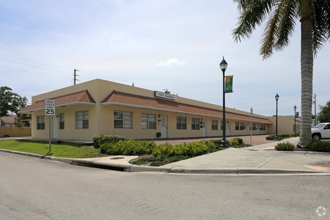
Property Record
3500 Ne 12Th Ave, Oakland Park, FL 33334
Current Lease Availabilities
NEARBY LISTINGS FOR SALE OR LEASE
Property Detail
3500 Ne 12Th Ave
Fort Lauderdale-Pompano Beach-Deerfield Beach, FL
Oakland Park 2-38 B
49-42-23-03-0750
OAKLAND PARK 2-38 B LOTS 9,10,11 LESS N 5 FOR RD, BLK 8
Officebuilding
Broward
X
Florida
12011C0367J
9-11
0
0.24 AC
2025
Fort Lauderdale
050602
South Florida
6,826 SF
DEMOGRAPHICS near 3500 Ne 12Th Ave
1 Mile
3 Mile
5 Mile
2024 Total Population
18,409
141,990
358,926
2029 Population
18,458
143,746
364,774
Pop Growth 2024-2029
+ 0.27%
+ 1.24%
+ 1.63%
Average Age
44
46
44
2024 Total Households
8,677
68,218
161,815
HH Growth 2024-2029
(0.15%)
+ 1.23%
+ 1.71%
Median Household Inc
$66,293
$70,768
$64,811
Avg Household Size
2.00
2.00
2.10
2024 Avg HH Vehicles
1.00
1.00
1.00
Median Home Value
$476,728
$481,193
$412,541
Median Year Built
1971
1970
1974
Nearby Places
Map Layers
Map Styles
 Street
 Aerial
- Restaurants
- Banks
- Shops
- Fitness
- Groceries
PUBLIC TRANSPORTATION
COMMUTER RAIL
Cypress Creek (Tri-County Commuter - South Florida Regional Transportation Authority (Tri-Rail))
DRIVE
WALK
Distance
Cypress Creek (Tri-County Commuter - South Florida Regional Transportation Authority (Tri-Rail))
8 min
3.3 mi
DRIVE
WALK
Distance
10 min
4.4 mi
AIRPORT
Fort Lauderdale/Hollywood International
DRIVE
WALK
Distance
Fort Lauderdale/Hollywood International
20 min
11.4 mi
Miami International
DRIVE
WALK
Distance
Miami International
57 min
36.6 mi
Nearby Properties
Address
Land Use
TOTAL SIZE
Lot Size
Zoning
Address
Land Use
TOTAL SIZE
Lot Size
Zoning
202,260 SF
443 AC
GAA
Address
Land Use
TOTAL SIZE
Lot Size
Zoning
730,297 SF
4.02 AC
B-1
Address
Land Use
TOTAL SIZE
Lot Size
Zoning
734,444 SF
5.26 AC
RAC-CC
Address
Land Use
TOTAL SIZE
Lot Size
Zoning
453,314 SF
2.01 AC
RAC-UV
Address
Land Use
TOTAL SIZE
Lot Size
Zoning
479,072 SF
2.02 AC
RAC-UV
Address
Land Use
TOTAL SIZE
Lot Size
Zoning
1,080,487 SF
27.58 AC
CF
Address
Land Use
TOTAL SIZE
Lot Size
Zoning
481,895 SF
1.86 AC
RAC-UV
Address
Land Use
TOTAL SIZE
Lot Size
Zoning
424,412 SF
2.39 AC
RAC-UV
Address
Land Use
TOTAL SIZE
Lot Size
Zoning
302,696 SF
42.40 AC
Address
Land Use
TOTAL SIZE
Lot Size
Zoning
287,591 SF
9.23 AC
MR
Address
Land Use
TOTAL SIZE
Lot Size
Zoning
377,156 SF
1.71 AC
RAC-UV
Address
Land Use
TOTAL SIZE
Lot Size
Zoning
435,442 SF
0.96 AC
RAC-CC
Address
Land Use
TOTAL SIZE
Lot Size
Zoning
531,570 SF
4.18 AC
B-1
Address
Land Use
TOTAL SIZE
Lot Size
Zoning
470,786 SF
1.58 AC
B-1
Address
Land Use
TOTAL SIZE
Lot Size
Zoning
188,965 SF
1.46 AC
Address
Land Use
TOTAL SIZE
Lot Size
Zoning
436,752 SF
2.09 AC
B-1
Address
Land Use
TOTAL SIZE
Lot Size
Zoning
1,726,840 SF
24.57 AC
B-1
Address
Land Use
TOTAL SIZE
Lot Size
Zoning
19,177 SF
92.14 AC
P
Address
Land Use
TOTAL SIZE
Lot Size
Zoning
141,832 SF
0.73 AC
SLA
Address
Land Use
TOTAL SIZE
Lot Size
Zoning
213,768 SF
10.23 AC
RM-25
Address
Land Use
TOTAL SIZE
Lot Size
Zoning
383,848 SF
2.54 AC
PUD
Address
Land Use
TOTAL SIZE
Lot Size
Zoning
216,569 SF
6.82 AC
TOC EAST
Address
Land Use
TOTAL SIZE
Lot Size
Zoning
296,703 SF
1.62 AC
RAC-CC
Address
Land Use
TOTAL SIZE
Lot Size
Zoning
418,713 SF
3.61 AC
B-1
Address
Land Use
TOTAL SIZE
Lot Size
Zoning
345,035 SF
49.57 AC
CF
Address
Land Use
TOTAL SIZE
Lot Size
Zoning
158,703 SF
7 AC
AIP
Address
Land Use
TOTAL SIZE
Lot Size
Zoning
134,706 SF
86.54 AC
P
Address
Land Use
TOTAL SIZE
Lot Size
Zoning
294,917 SF
25.52 AC
CF
Address
Land Use
TOTAL SIZE
Lot Size
Zoning
155,760 SF
5.69 AC
RAC-UV
Address
Land Use
TOTAL SIZE
Lot Size
Zoning
223,809 SF
18.56 AC
B-2
The World's #1 Commercial Real Estate Marketplace
Connect with us
© 2025 CoStar Group
The information above has been obtained from sources believed reliable. While we do not doubt its accuracy we have not verified it and make no guarantee, warranty or representation about it. It is your responsibility to independently confirm its accuracy and completeness. Any projections, opinions, assumptions, or estimates used are for example only and do not represent the current or future performance of the property. The value of this transaction to you depends on tax and other factors which should be evaluated by your tax, financial, and legal advisors. You and your advisors should conduct a careful, independent investigation of the property to determine to your satisfaction the suitability of the property for your needs.