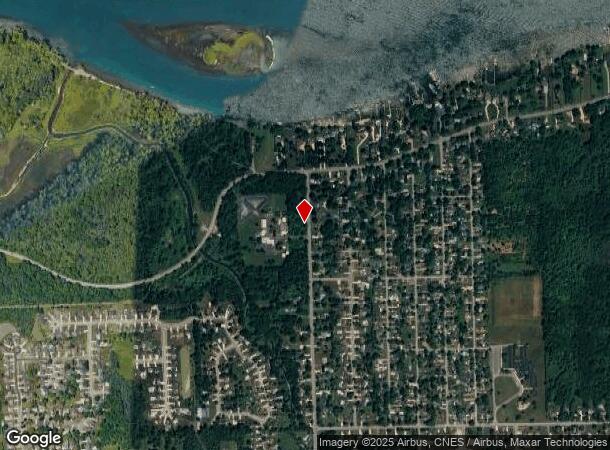
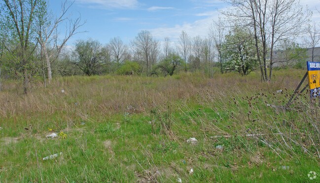
Property Record
3500 Baseline Rd, Grand Island, NY 14072

NEARBY LISTINGS FOR SALE OR LEASE
Property Detail
3500 Baseline Rd
144600-011-000-0001-005-000-A
BUCKHORN PARK LEASED SEWER DIST 2 PLANT 350 X 550 4.41 AC
Wastedisposalsewagetreatmentfacility
Erie
AE
New York
36029C0036J
5.000
0
4.41 AC
2024
North
007303
Buffalo/Niagara Falls
17,941 SF
Buffalo-Cheektowaga-Niagara Falls, NY
DEMOGRAPHICS near 3500 Baseline Rd
1 Mile
3 Mile
5 Mile
2024 Total Population
4,338
19,106
75,225
2029 Population
4,398
19,197
74,565
Pop Growth 2024-2029
+ 1.38%
+ 0.48%
(0.88%)
Average Age
44
43
43
2024 Total Households
1,922
7,743
33,383
HH Growth 2024-2029
+ 1.82%
+ 0.57%
(0.97%)
Median Household Inc
$81,497
$93,962
$66,007
Avg Household Size
2.10
2.40
2.20
2024 Avg HH Vehicles
2.00
2.00
2.00
Median Home Value
$259,669
$265,698
$171,372
Median Year Built
1976
1977
1956
Nearby Places
Map Layers
Map Styles
 Street
 Aerial
- Restaurants
- Banks
- Shops
- Fitness
- Groceries
PUBLIC TRANSPORTATION
COMMUTER RAIL
Niagara Falls Station (Toronto - New York - VIA Rail)
DRIVE
WALK
Distance
Niagara Falls Station (Toronto - New York - VIA Rail)
15 min
8.4 mi
Niagara Falls Amtrak Station (Empire Service - Amtrak, Maple Leaf - Amtrak)
DRIVE
WALK
Distance
Niagara Falls Amtrak Station (Empire Service - Amtrak, Maple Leaf - Amtrak)
15 min
8.7 mi
AIRPORT
Niagara Falls International
DRIVE
WALK
Distance
Niagara Falls International
13 min
7.3 mi
Buffalo Niagara International
DRIVE
WALK
Distance
Buffalo Niagara International
31 min
20.5 mi
Freight Ports
Port of Toledo
DRIVE
WALK
Distance
Port of Toledo
376 min
306.4 mi
Nearby Properties
Address
Land Use
TOTAL SIZE
Lot Size
Zoning
Address
Land Use
TOTAL SIZE
Lot Size
Zoning
22.40 AC
INS
Address
Land Use
TOTAL SIZE
Lot Size
Zoning
14.70 AC
I2
Address
Land Use
TOTAL SIZE
Lot Size
Zoning
86,660 SF
11.60 AC
I2
Address
Land Use
TOTAL SIZE
Lot Size
Zoning
3,600 SF
72.50 AC
Address
Land Use
TOTAL SIZE
Lot Size
Zoning
9,626 SF
31.67 AC
Address
Land Use
TOTAL SIZE
Lot Size
Zoning
368,190 SF
98.37 AC
R1D
Address
Land Use
TOTAL SIZE
Lot Size
Zoning
410,860 SF
35.20 AC
05 - COMME
Address
Land Use
TOTAL SIZE
Lot Size
Zoning
0.30 AC
R1-C
Address
Land Use
TOTAL SIZE
Lot Size
Zoning
17,820 SF
29.86 AC
CBD
Address
Land Use
TOTAL SIZE
Lot Size
Zoning
58,226 SF
16.40 AC
Address
Land Use
TOTAL SIZE
Lot Size
Zoning
Address
Land Use
TOTAL SIZE
Lot Size
Zoning
240,000 SF
35.50 AC
05 - COMME
Address
Land Use
TOTAL SIZE
Lot Size
Zoning
Address
Land Use
TOTAL SIZE
Lot Size
Zoning
Address
Land Use
TOTAL SIZE
Lot Size
Zoning
36,700 SF
11.29 AC
B1
Address
Land Use
TOTAL SIZE
Lot Size
Zoning
11,442 SF
23.87 AC
Address
Land Use
TOTAL SIZE
Lot Size
Zoning
211,484 SF
18.30 AC
C3
Address
Land Use
TOTAL SIZE
Lot Size
Zoning
22,014 SF
26.62 AC
R3
Address
Land Use
TOTAL SIZE
Lot Size
Zoning
22,014 SF
14.20 AC
R3
Address
Land Use
TOTAL SIZE
Lot Size
Zoning
Address
Land Use
TOTAL SIZE
Lot Size
Zoning
10,647 SF
14 AC
C3
Address
Land Use
TOTAL SIZE
Lot Size
Zoning
33.14 AC
C3
Address
Land Use
TOTAL SIZE
Lot Size
Zoning
6,369 SF
12.58 AC
C3
Address
Land Use
TOTAL SIZE
Lot Size
Zoning
117,095 SF
8.91 AC
C3
Address
Land Use
TOTAL SIZE
Lot Size
Zoning
1,200 SF
49.80 AC
05 - COMME
Address
Land Use
TOTAL SIZE
Lot Size
Zoning
1,040 SF
592.10 AC
OS
Address
Land Use
TOTAL SIZE
Lot Size
Zoning
131,133 SF
14.60 AC
05 - COMME
Address
Land Use
TOTAL SIZE
Lot Size
Zoning
41.96 AC
Address
Land Use
TOTAL SIZE
Lot Size
Zoning
101,390 SF
12.16 AC
C3
The World's #1 Commercial Real Estate Marketplace
Connect with us
© 2026 CoStar Group
The information above has been obtained from sources believed reliable. While we do not doubt its accuracy we have not verified it and make no guarantee, warranty or representation about it. It is your responsibility to independently confirm its accuracy and completeness. Any projections, opinions, assumptions, or estimates used are for example only and do not represent the current or future performance of the property. The value of this transaction to you depends on tax and other factors which should be evaluated by your tax, financial, and legal advisors. You and your advisors should conduct a careful, independent investigation of the property to determine to your satisfaction the suitability of the property for your needs.