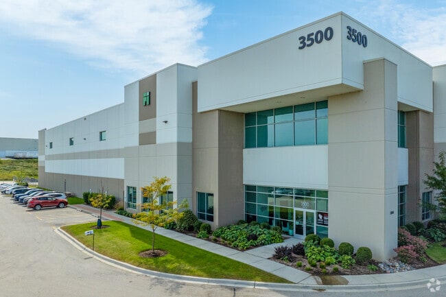
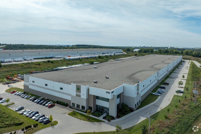
Property Record
3500 Channahon Rd, Joliet, IL 60436

Save to a Folder
{{folder.Name}}
{{folder.ListingIds.length}} Properties
{{folder.ListingIds.length}} Property
Create a New Folder
Current Lease Availabilities
Property Detail
3500 Channahon Rd
Chicago-Naperville-Elgin, IL-IN
LOT 2 IN KETONE BUSINESS CENTER UNIT 1 SUB, BEING A SUB OF PRT OF SEC. 25, 26, 35 36, T35N-R9E.
05-06-35-201-005
WILL
Industrialgeneral
Illinois
AE The base floodplain where base flood elevations are provided. AE Zones are now used on new format FIRMs instead of A1-A30 Zones.
2
2025
35.65 AC
2024
Joliet Area
883211
Chicago
NEARBY LISTINGS FOR SALE OR LEASE
DEMOGRAPHICS near 3500 Channahon Rd
1 mile
3 mile
5 mile
2025 Total Population
542
11,402
85,389
2030 Population
557
11,765
86,911
Pop Growth 2025-2030
+ 2.77%
+ 3.18%
+ 1.78%
Average Age
45
40
41
2025 Total Households
215
4,048
32,463
HH Growth 2025-2030
+ 2.79%
+ 3.14%
+ 1.76%
Median Household Inc
$81,604
$96,646
$83,978
Avg Household Size
2.50
2.70
2.60
2025 Avg HH Vehicles
2.00
2.00
2.00
Median Home Value
$250,515
$269,391
$267,743
Median Year Built
1969
1993
1977
Nearby Places
Map Layers
Map Styles
 Street
 Aerial
Layers
 Traffic
 Biking
Places
Listings with unknown addresses are not visible on the map
- Restaurants
- Banks
- Shops
- Fitness
- Groceries
PUBLIC TRANSPORTATION
COMMUTER RAIL
Joliet Station (Heritage Corridor Line - Northeast Illinois Regional Commuter Railroad (Metra), Rock Island District Line - Northeast Illinois Regional Commuter Railroad (Metra))
Drive
Walk
Distance
Joliet Station (Heritage Corridor Line - Northeast Illinois Regional Commuter Railroad (Metra), Rock Island District Line - Northeast Illinois Regional Commuter Railroad (Metra))
12 min
6.0 mi
Freight Ports
Port Milwaukee
Drive
Walk
Distance
Port Milwaukee
150 min
121.6 mi
Nearby Properties
Address
Land Use
TOTAL SIZE
Lot Size
Zoning
Address
Land Use
TOTAL SIZE
Lot Size
Zoning
1,617,159 SF
74.66 AC
Address
Land Use
TOTAL SIZE
Lot Size
Zoning
79.79 AC
Address
Land Use
TOTAL SIZE
Lot Size
Zoning
75.30 AC
Address
Land Use
TOTAL SIZE
Lot Size
Zoning
273.07 AC
Address
Land Use
TOTAL SIZE
Lot Size
Zoning
52.75 AC
Address
Land Use
TOTAL SIZE
Lot Size
Zoning
50.58 AC
Address
Land Use
TOTAL SIZE
Lot Size
Zoning
60,212 SF
61.11 AC
Address
Land Use
TOTAL SIZE
Lot Size
Zoning
146.25 AC
Address
Land Use
TOTAL SIZE
Lot Size
Zoning
48.10 AC
Address
Land Use
TOTAL SIZE
Lot Size
Zoning
51.97 AC
Address
Land Use
TOTAL SIZE
Lot Size
Zoning
37.57 AC
Address
Land Use
TOTAL SIZE
Lot Size
Zoning
54.84 AC
Address
Land Use
TOTAL SIZE
Lot Size
Zoning
502,836 SF
24.99 AC
Address
Land Use
TOTAL SIZE
Lot Size
Zoning
31.43 AC
Address
Land Use
TOTAL SIZE
Lot Size
Zoning
445,236 SF
20.40 AC
Address
Land Use
TOTAL SIZE
Lot Size
Zoning
474,432 SF
33.20 AC
Address
Land Use
TOTAL SIZE
Lot Size
Zoning
459,070 SF
22.35 AC
Address
Land Use
TOTAL SIZE
Lot Size
Zoning
20.37 AC
Address
Land Use
TOTAL SIZE
Lot Size
Zoning
408,850 SF
18.27 AC
Address
Land Use
TOTAL SIZE
Lot Size
Zoning
30.14 AC
Address
Land Use
TOTAL SIZE
Lot Size
Zoning
322,874 SF
13.71 AC
Address
Land Use
TOTAL SIZE
Lot Size
Zoning
22.74 AC
Address
Land Use
TOTAL SIZE
Lot Size
Zoning
15.31 AC
Address
Land Use
TOTAL SIZE
Lot Size
Zoning
309,840 SF
13.24 AC
Address
Land Use
TOTAL SIZE
Lot Size
Zoning
16.04 AC
Address
Land Use
TOTAL SIZE
Lot Size
Zoning
277,776 SF
14.17 AC
Address
Land Use
TOTAL SIZE
Lot Size
Zoning
44.81 AC
Address
Land Use
TOTAL SIZE
Lot Size
Zoning
233,120 SF
10.57 AC
Address
Land Use
TOTAL SIZE
Lot Size
Zoning
17.58 AC
The World's #1 Commercial Real Estate Marketplace
Connect with us
© 2026 CoStar Group
The information above has been obtained from sources believed reliable. While we do not doubt its accuracy we have not verified it and make no guarantee, warranty or representation about it. It is your responsibility to independently confirm its accuracy and completeness. Any projections, opinions, assumptions, or estimates used are for example only and do not represent the current or future performance of the property. The value of this transaction to you depends on tax and other factors which should be evaluated by your tax, financial, and legal advisors. You and your advisors should conduct a careful, independent investigation of the property to determine to your satisfaction the suitability of the property for your needs.