Property Record
3500 Federal Dr, Saint Paul, MN 55122
NEARBY LISTINGS FOR SALE OR LEASE
Property Detail
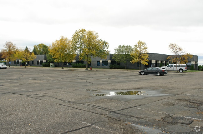
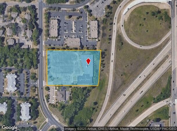
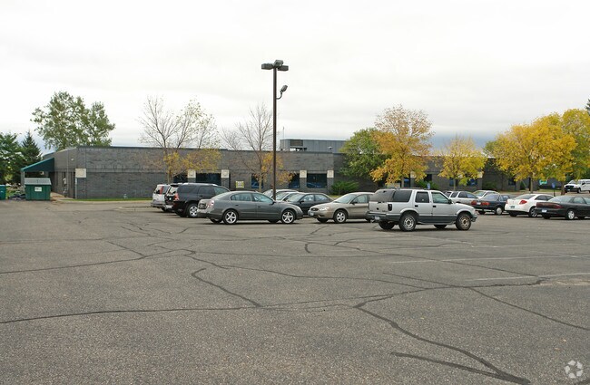
3500 Federal Dr
Minneapolis-St. Paul-Bloomington, MN-WI
Rasmussen College Campus
10-62950-01-010
RASMUSSEN COLLEGE CAMPUS 1 1
Religious
Dakota
X
Minnesota
27053C0500F
10
0
3.92 AC
2024
Burnsville/Eagan/Apple Vy
060716
Minneapolis/St Paul
30,817 SF
DEMOGRAPHICS near 3500 Federal Dr
1 Mile
3 Mile
5 Mile
2024 Total Population
10,027
53,611
128,973
2029 Population
10,257
54,735
130,847
Pop Growth 2024-2029
+ 2.29%
+ 2.10%
+ 1.45%
Average Age
39
40
40
2024 Total Households
4,563
22,265
51,421
HH Growth 2024-2029
+ 2.43%
+ 2.17%
+ 1.47%
Median Household Inc
$78,596
$92,107
$95,336
Avg Household Size
2.20
2.30
2.40
2024 Avg HH Vehicles
2.00
2.00
2.00
Median Home Value
$331,134
$346,479
$350,588
Median Year Built
1985
1986
1984
Nearby Places
Map Layers
Map Styles
 Street
 Aerial
- Restaurants
- Banks
- Shops
- Fitness
- Groceries
PUBLIC TRANSPORTATION
AIRPORT
Minneapolis-St Paul International/Wold-Chamberlain
DRIVE
WALK
Distance
Minneapolis-St Paul International/Wold-Chamberlain
14 min
7.0 mi
SALE & LEASE HISTORY
LISTING DATE
SALE/LEASE

Aug 05, 2019
For Lease
Aug 05, 2019
For Sale
Nearby Properties
Address
Land Use
TOTAL SIZE
Lot Size
Zoning
Address
Land Use
TOTAL SIZE
Lot Size
Zoning
752,064 SF
24.03 AC
Address
Land Use
TOTAL SIZE
Lot Size
Zoning
466,503 SF
28.74 AC
Address
Land Use
TOTAL SIZE
Lot Size
Zoning
587,427 SF
87.26 AC
Address
Land Use
TOTAL SIZE
Lot Size
Zoning
300,663 SF
4.81 AC
Address
Land Use
TOTAL SIZE
Lot Size
Zoning
657,358 SF
17.12 AC
Address
Land Use
TOTAL SIZE
Lot Size
Zoning
264,370 SF
36.39 AC
Address
Land Use
TOTAL SIZE
Lot Size
Zoning
168,729 SF
19.02 AC
Address
Land Use
TOTAL SIZE
Lot Size
Zoning
282,095 SF
2.71 AC
Address
Land Use
TOTAL SIZE
Lot Size
Zoning
263,460 SF
3.08 AC
Address
Land Use
TOTAL SIZE
Lot Size
Zoning
383,495 SF
15.41 AC
Address
Land Use
TOTAL SIZE
Lot Size
Zoning
291,589 SF
6.77 AC
Address
Land Use
TOTAL SIZE
Lot Size
Zoning
246,636 SF
7.20 AC
Address
Land Use
TOTAL SIZE
Lot Size
Zoning
192,843 SF
13.32 AC
Address
Land Use
TOTAL SIZE
Lot Size
Zoning
206,818 SF
2.84 AC
Address
Land Use
TOTAL SIZE
Lot Size
Zoning
300,000 SF
18.44 AC
Address
Land Use
TOTAL SIZE
Lot Size
Zoning
314,237 SF
10.63 AC
Address
Land Use
TOTAL SIZE
Lot Size
Zoning
240,316 SF
9.57 AC
Address
Land Use
TOTAL SIZE
Lot Size
Zoning
201,481 SF
6.69 AC
Address
Land Use
TOTAL SIZE
Lot Size
Zoning
Address
Land Use
TOTAL SIZE
Lot Size
Zoning
170,292 SF
2.08 AC
Address
Land Use
TOTAL SIZE
Lot Size
Zoning
134,298 SF
16.70 AC
Address
Land Use
TOTAL SIZE
Lot Size
Zoning
247,451 SF
9.57 AC
Address
Land Use
TOTAL SIZE
Lot Size
Zoning
110,979 SF
9.65 AC
Address
Land Use
TOTAL SIZE
Lot Size
Zoning
278,320 SF
31.12 AC
Address
Land Use
TOTAL SIZE
Lot Size
Zoning
159,341 SF
2.82 AC
Address
Land Use
TOTAL SIZE
Lot Size
Zoning
1,339,582 SF
78.22 AC
Address
Land Use
TOTAL SIZE
Lot Size
Zoning
162,372 SF
9.11 AC
Address
Land Use
TOTAL SIZE
Lot Size
Zoning
436,701 SF
19.58 AC
Address
Land Use
TOTAL SIZE
Lot Size
Zoning
281,133 SF
23.21 AC
The World's #1 Commercial Real Estate Marketplace
Connect with us
© 2025 CoStar Group
The information above has been obtained from sources believed reliable. While we do not doubt its accuracy we have not verified it and make no guarantee, warranty or representation about it. It is your responsibility to independently confirm its accuracy and completeness. Any projections, opinions, assumptions, or estimates used are for example only and do not represent the current or future performance of the property. The value of this transaction to you depends on tax and other factors which should be evaluated by your tax, financial, and legal advisors. You and your advisors should conduct a careful, independent investigation of the property to determine to your satisfaction the suitability of the property for your needs.