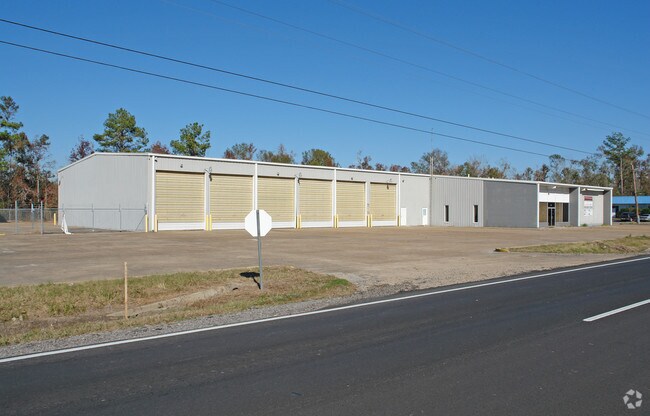
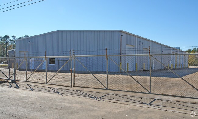
Property Record
3500 Interstate 10 W, Orange, TX 77632

Property Detail
3500 Interstate 10 W
Beaumont-Port Arthur, TX
BROADMOOR TERRACE, BLOCK 2, LOT 1 - 5, ACRES 6.188
001625-000050
ORANGE
Commercialnec
Texas
B and X Area of moderate flood hazard, usually the area between the limits of the 100-year and 500-year floods.
1-5
2025
6.19 AC
2025
Orange County
021300
Beaumont/Port Arthur
25,010 SF
NEARBY LISTINGS FOR SALE OR LEASE
DEMOGRAPHICS near 3500 Interstate 10 W
1 mile
3 mile
5 mile
2025 Total Population
2,296
22,375
32,996
2030 Population
2,325
22,831
33,699
Pop Growth 2025-2030
+ 1.26%
+ 2.04%
+ 2.13%
Average Age
41
39
40
2025 Total Households
956
9,113
13,349
HH Growth 2025-2030
+ 1.26%
+ 2.04%
+ 2.16%
Median Household Inc
$55,108
$54,403
$58,111
Avg Household Size
2.40
2.40
2.40
2025 Avg HH Vehicles
2.00
2.00
2.00
Median Home Value
$175,619
$157,550
$161,513
Median Year Built
1979
1974
1977
Nearby Places
Map Layers
Map Styles
 Street
 Aerial
Layers
 Traffic
 Biking
Places
Listings with unknown addresses are not visible on the map
- Restaurants
- Banks
- Shops
- Fitness
- Groceries
PUBLIC TRANSPORTATION
AIRPORT
Lake Charles Regional
Drive
Walk
Distance
Lake Charles Regional
54 min
42.7 mi
SALE & LEASE HISTORY
LISTING DATE
SALE/LEASE

Sep 23, 2016
For Sale
Nearby Properties
Address
Land Use
TOTAL SIZE
Lot Size
Zoning
Address
Land Use
TOTAL SIZE
Lot Size
Zoning
Address
Land Use
TOTAL SIZE
Lot Size
Zoning
153,221 SF
13.82 AC
Address
Land Use
TOTAL SIZE
Lot Size
Zoning
181,555 SF
23.55 AC
Address
Land Use
TOTAL SIZE
Lot Size
Zoning
75,598 SF
16.89 AC
Address
Land Use
TOTAL SIZE
Lot Size
Zoning
129,730 SF
2.60 AC
Address
Land Use
TOTAL SIZE
Lot Size
Zoning
198,977 SF
22.63 AC
Address
Land Use
TOTAL SIZE
Lot Size
Zoning
40,158 SF
3.98 AC
Address
Land Use
TOTAL SIZE
Lot Size
Zoning
57,547 SF
6.87 AC
Address
Land Use
TOTAL SIZE
Lot Size
Zoning
77,632 SF
8.88 AC
Address
Land Use
TOTAL SIZE
Lot Size
Zoning
69,008 SF
19.31 AC
Address
Land Use
TOTAL SIZE
Lot Size
Zoning
28,568 SF
16.36 AC
Address
Land Use
TOTAL SIZE
Lot Size
Zoning
41,148 SF
14.77 AC
Address
Land Use
TOTAL SIZE
Lot Size
Zoning
80,440 SF
8.98 AC
Address
Land Use
TOTAL SIZE
Lot Size
Zoning
51,090 SF
6.61 AC
Address
Land Use
TOTAL SIZE
Lot Size
Zoning
18,902 SF
Address
Land Use
TOTAL SIZE
Lot Size
Zoning
14,381 SF
3.39 AC
Address
Land Use
TOTAL SIZE
Lot Size
Zoning
40,986 SF
2.01 AC
Address
Land Use
TOTAL SIZE
Lot Size
Zoning
12,747 SF
0.64 AC
Address
Land Use
TOTAL SIZE
Lot Size
Zoning
12,860 SF
2.24 AC
Address
Land Use
TOTAL SIZE
Lot Size
Zoning
42,448 SF
25.08 AC
Address
Land Use
TOTAL SIZE
Lot Size
Zoning
11,108 SF
25 AC
Address
Land Use
TOTAL SIZE
Lot Size
Zoning
14,398 SF
2.07 AC
Address
Land Use
TOTAL SIZE
Lot Size
Zoning
102,513 SF
12.51 AC
Address
Land Use
TOTAL SIZE
Lot Size
Zoning
42,363 SF
7.54 AC
Address
Land Use
TOTAL SIZE
Lot Size
Zoning
7,168 SF
1.12 AC
Address
Land Use
TOTAL SIZE
Lot Size
Zoning
22,080 SF
10.53 AC
Address
Land Use
TOTAL SIZE
Lot Size
Zoning
13,668 SF
1.64 AC
Address
Land Use
TOTAL SIZE
Lot Size
Zoning
25,448 SF
12.16 AC
The World's #1 Commercial Real Estate Marketplace
Connect with us
© 2026 CoStar Group
The information above has been obtained from sources believed reliable. While we do not doubt its accuracy we have not verified it and make no guarantee, warranty or representation about it. It is your responsibility to independently confirm its accuracy and completeness. Any projections, opinions, assumptions, or estimates used are for example only and do not represent the current or future performance of the property. The value of this transaction to you depends on tax and other factors which should be evaluated by your tax, financial, and legal advisors. You and your advisors should conduct a careful, independent investigation of the property to determine to your satisfaction the suitability of the property for your needs.