Property Record
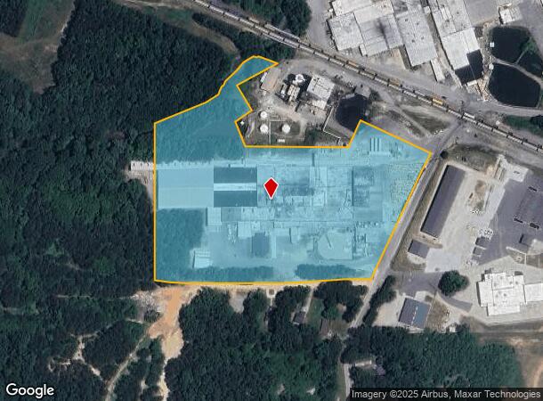
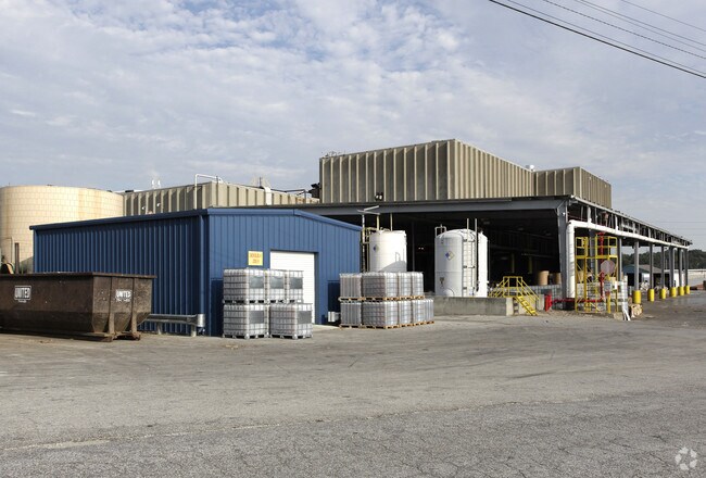
3500 Joe Jerkins Blvd, Austell, GA 30106

NEARBY LISTINGS FOR SALE OR LEASE
Property Detail
3500 Joe Jerkins Blvd
19-1311-0-001-0
Cobb
Paperalliedindustry
Georgia
AE
1310
13067C0184H
13.70 AC
2025
I-20 W/Douglasville
2025
Atlanta
031415
Atlanta-Sandy Springs-Roswell, GA
173,635 SF
DEMOGRAPHICS near 3500 Joe Jerkins Blvd
1 Mile
3 Mile
5 Mile
2024 Total Population
3,904
42,636
126,744
2029 Population
4,019
43,788
130,149
Pop Growth 2024-2029
+ 2.95%
+ 2.70%
+ 2.69%
Average Age
38
38
38
2024 Total Households
1,368
15,641
46,081
HH Growth 2024-2029
+ 2.85%
+ 2.78%
+ 2.68%
Median Household Inc
$60,099
$62,305
$67,532
Avg Household Size
2.80
2.70
2.70
2024 Avg HH Vehicles
2.00
2.00
2.00
Median Home Value
$169,538
$198,655
$225,186
Median Year Built
1984
1987
1988
Nearby Places
Map Layers
Map Styles
 Street
 Aerial
- Restaurants
- Banks
- Shops
- Fitness
- Groceries
PUBLIC TRANSPORTATION
AIRPORT
Hartsfield - Jackson Atlanta International
DRIVE
WALK
Distance
Hartsfield - Jackson Atlanta International
40 min
26.3 mi
Freight Ports
Georgia Ports - Savannah
DRIVE
WALK
Distance
Georgia Ports - Savannah
303 min
265.6 mi
Nearby Properties
Address
Land Use
TOTAL SIZE
Lot Size
Zoning
Address
Land Use
TOTAL SIZE
Lot Size
Zoning
840,110 SF
53.36 AC
PUD
Address
Land Use
TOTAL SIZE
Lot Size
Zoning
320,073 SF
38.78 AC
R-MF
Address
Land Use
TOTAL SIZE
Lot Size
Zoning
318,456 SF
30.91 AC
R-MF
Address
Land Use
TOTAL SIZE
Lot Size
Zoning
285,933 SF
46.22 AC
R-MF
Address
Land Use
TOTAL SIZE
Lot Size
Zoning
Address
Land Use
TOTAL SIZE
Lot Size
Zoning
380,000 SF
33.97 AC
IL
Address
Land Use
TOTAL SIZE
Lot Size
Zoning
312,093 SF
19.79 AC
PUD
Address
Land Use
TOTAL SIZE
Lot Size
Zoning
312,240 SF
24.58 AC
PUD
Address
Land Use
TOTAL SIZE
Lot Size
Zoning
225,600 SF
50.68 AC
LI-R
Address
Land Use
TOTAL SIZE
Lot Size
Zoning
122,697 SF
13.02 AC
PUD
Address
Land Use
TOTAL SIZE
Lot Size
Zoning
284,307 SF
15.75 AC
LI-R
Address
Land Use
TOTAL SIZE
Lot Size
Zoning
78.60 AC
R20
Address
Land Use
TOTAL SIZE
Lot Size
Zoning
247,000 SF
17.77 AC
PUD
Address
Land Use
TOTAL SIZE
Lot Size
Zoning
261,100 SF
18.52 AC
PUD
Address
Land Use
TOTAL SIZE
Lot Size
Zoning
222,414 SF
11.51 AC
PUD
Address
Land Use
TOTAL SIZE
Lot Size
Zoning
183,750 SF
10.39 AC
PUD
Address
Land Use
TOTAL SIZE
Lot Size
Zoning
115,088 SF
18.24 AC
PUD
Address
Land Use
TOTAL SIZE
Lot Size
Zoning
195,000 SF
17.55 AC
PUD
Address
Land Use
TOTAL SIZE
Lot Size
Zoning
224,000 SF
28.83 AC
PUD
Address
Land Use
TOTAL SIZE
Lot Size
Zoning
153,774 SF
14.64 AC
PUD
Address
Land Use
TOTAL SIZE
Lot Size
Zoning
78,540 SF
10.17 AC
CG
Address
Land Use
TOTAL SIZE
Lot Size
Zoning
99,357 SF
6.04 AC
PUD
Address
Land Use
TOTAL SIZE
Lot Size
Zoning
39,956 SF
3.53 AC
CG
Address
Land Use
TOTAL SIZE
Lot Size
Zoning
150,934 SF
13.06 AC
LI
Address
Land Use
TOTAL SIZE
Lot Size
Zoning
33,876 SF
2.10 AC
CG
Address
Land Use
TOTAL SIZE
Lot Size
Zoning
122,640 SF
13.91 AC
PUD
Address
Land Use
TOTAL SIZE
Lot Size
Zoning
84,399 SF
18.35 AC
PUD
Address
Land Use
TOTAL SIZE
Lot Size
Zoning
122,640 SF
7.47 AC
PUD
Address
Land Use
TOTAL SIZE
Lot Size
Zoning
260,792 SF
39.25 AC
LI
Address
Land Use
TOTAL SIZE
Lot Size
Zoning
87,605 SF
5.27 AC
PUD
The World's #1 Commercial Real Estate Marketplace
Connect with us
© 2025 CoStar Group
The information above has been obtained from sources believed reliable. While we do not doubt its accuracy we have not verified it and make no guarantee, warranty or representation about it. It is your responsibility to independently confirm its accuracy and completeness. Any projections, opinions, assumptions, or estimates used are for example only and do not represent the current or future performance of the property. The value of this transaction to you depends on tax and other factors which should be evaluated by your tax, financial, and legal advisors. You and your advisors should conduct a careful, independent investigation of the property to determine to your satisfaction the suitability of the property for your needs.