Property Record
3500 Main Maip St, Pryor, OK 74361


NEARBY LISTINGS FOR SALE OR LEASE
-
-
View all Pryor listings for sale on LoopNet.com
Property Detail
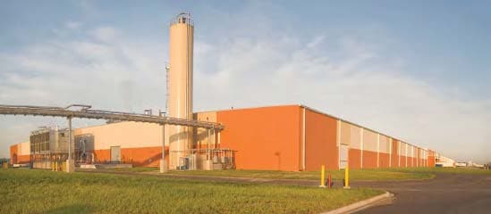
3500 Main Maip St
0000-06-20N-19E-1-002-00
T20n-R19e
Warehouse
06-20N-19ECOMM W QTR COR THEN N88?54E 1039.16 N01?06W 93.92 TO POB THEN N01?38'32W1576.39 ALG CURVE TO THE RIGHT HAVING A RAD
X
Mayes
40097C0330E
Oklahoma
2025
152.10 AC
2025
Oklahoma East Area
040100
Other Market Areas
1,351,912 SF
DEMOGRAPHICS near 3500 Main Maip St
1 Mile
3 Mile
5 Mile
2024 Total Population
480
2,920
14,684
2029 Population
496
3,005
15,192
Pop Growth 2024-2029
+ 3.33%
+ 2.91%
+ 3.46%
Average Age
40
39
38
2024 Total Households
174
1,134
5,672
HH Growth 2024-2029
+ 3.45%
+ 2.91%
+ 3.51%
Median Household Inc
$85,714
$65,021
$47,556
Avg Household Size
2.60
2.50
2.50
2024 Avg HH Vehicles
3.00
2.00
2.00
Median Home Value
$248,809
$187,379
$149,317
Median Year Built
1996
1981
1976
Nearby Places
Map Layers
Map Styles
 Street
 Aerial
- Restaurants
- Banks
- Shops
- Fitness
- Groceries
Nearby Properties
Address
Land Use
TOTAL SIZE
Lot Size
Zoning
Address
Land Use
TOTAL SIZE
Lot Size
Zoning
99.05 AC
Address
Land Use
TOTAL SIZE
Lot Size
Zoning
106,688 SF
55.22 AC
Address
Land Use
TOTAL SIZE
Lot Size
Zoning
84,200 SF
384.40 AC
Address
Land Use
TOTAL SIZE
Lot Size
Zoning
4,800 SF
5.50 AC
Address
Land Use
TOTAL SIZE
Lot Size
Zoning
500.77 AC
Address
Land Use
TOTAL SIZE
Lot Size
Zoning
4,926 SF
10 AC
Address
Land Use
TOTAL SIZE
Lot Size
Zoning
181,766 SF
19.29 AC
Address
Land Use
TOTAL SIZE
Lot Size
Zoning
27,650 SF
17.66 AC
Address
Land Use
TOTAL SIZE
Lot Size
Zoning
1,500 SF
19.30 AC
Address
Land Use
TOTAL SIZE
Lot Size
Zoning
28,440 SF
11.50 AC
Address
Land Use
TOTAL SIZE
Lot Size
Zoning
1,200 SF
39.54 AC
Address
Land Use
TOTAL SIZE
Lot Size
Zoning
133,672 SF
16.55 AC
Address
Land Use
TOTAL SIZE
Lot Size
Zoning
154,162 SF
12.30 AC
Address
Land Use
TOTAL SIZE
Lot Size
Zoning
1,700 SF
19.52 AC
Address
Land Use
TOTAL SIZE
Lot Size
Zoning
Address
Land Use
TOTAL SIZE
Lot Size
Zoning
77,275 SF
9.96 AC
Address
Land Use
TOTAL SIZE
Lot Size
Zoning
33,042 SF
1.90 AC
Address
Land Use
TOTAL SIZE
Lot Size
Zoning
46,966 SF
12.03 AC
Address
Land Use
TOTAL SIZE
Lot Size
Zoning
3,200 SF
2.29 AC
Address
Land Use
TOTAL SIZE
Lot Size
Zoning
54,340 SF
1.30 AC
Address
Land Use
TOTAL SIZE
Lot Size
Zoning
1,040 SF
445.46 AC
The World's #1 Commercial Real Estate Marketplace
Connect with us
© 2026 CoStar Group
The information above has been obtained from sources believed reliable. While we do not doubt its accuracy we have not verified it and make no guarantee, warranty or representation about it. It is your responsibility to independently confirm its accuracy and completeness. Any projections, opinions, assumptions, or estimates used are for example only and do not represent the current or future performance of the property. The value of this transaction to you depends on tax and other factors which should be evaluated by your tax, financial, and legal advisors. You and your advisors should conduct a careful, independent investigation of the property to determine to your satisfaction the suitability of the property for your needs.