Property Record
2253 Mazette Rd, Pittsburgh, PA 15205


Property Detail
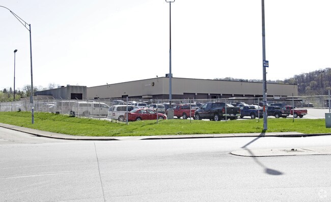
2253 Mazette Rd
Pittsburgh, PA
21.265 ALD BROADHEAD FORDING RD & MAZETTE RD 1 STY BRK OFFICE & WHSE 1 STY CONC TRUCK WASH BLDG
0107-M-00295-0000-00
Allegheny
Warehouse
Pennsylvania
B and X Area of moderate flood hazard, usually the area between the limits of the 100-year and 500-year floods.
295
2024
21.27 AC
2025
West Pittsburgh
563000
Pittsburgh
NEARBY LISTINGS FOR SALE OR LEASE
DEMOGRAPHICS near 2253 Mazette Rd
1 mile
3 mile
5 mile
2025 Total Population
4,790
67,065
206,380
2030 Population
4,742
66,403
204,360
Pop Growth 2025-2030
(1.00%)
(0.99%)
(0.98%)
Average Age
41
42
42
2025 Total Households
2,200
30,242
96,041
HH Growth 2025-2030
(1.00%)
(1.02%)
(1.06%)
Median Household Inc
$68,333
$67,899
$73,728
Avg Household Size
2.10
2.20
2.10
2025 Avg HH Vehicles
1.00
1.00
1.00
Median Home Value
$167,087
$183,997
$217,359
Median Year Built
1957
1956
1953
Nearby Places
Map Layers
Map Styles
 Street
 Aerial
Layers
 Traffic
 Biking
Places
Listings with unknown addresses are not visible on the map
- Restaurants
- Banks
- Shops
- Fitness
- Groceries
PUBLIC TRANSPORTATION
COMMUTER RAIL
Pittsburgh Amtrak Station (Capitol Limited - Amtrak, Pennsylvanian - Amtrak)
Drive
Walk
Distance
Pittsburgh Amtrak Station (Capitol Limited - Amtrak, Pennsylvanian - Amtrak)
14 min
7.3 mi
AIRPORT
Pittsburgh International
Drive
Walk
Distance
Pittsburgh International
24 min
12.8 mi
Freight Ports
Port of Toledo
Drive
Walk
Distance
Port of Toledo
268 min
232.5 mi
Nearby Properties
Address
Land Use
TOTAL SIZE
Lot Size
Zoning
Address
Land Use
TOTAL SIZE
Lot Size
Zoning
26.68 AC
Address
Land Use
TOTAL SIZE
Lot Size
Zoning
21.20 AC
Address
Land Use
TOTAL SIZE
Lot Size
Zoning
105.09 AC
Address
Land Use
TOTAL SIZE
Lot Size
Zoning
33.43 AC
Address
Land Use
TOTAL SIZE
Lot Size
Zoning
6.40 AC
Address
Land Use
TOTAL SIZE
Lot Size
Zoning
16.54 AC
Address
Land Use
TOTAL SIZE
Lot Size
Zoning
20.19 AC
Address
Land Use
TOTAL SIZE
Lot Size
Zoning
1,556 SF
36.30 AC
Address
Land Use
TOTAL SIZE
Lot Size
Zoning
Address
Land Use
TOTAL SIZE
Lot Size
Zoning
16.01 AC
Address
Land Use
TOTAL SIZE
Lot Size
Zoning
25.09 AC
Address
Land Use
TOTAL SIZE
Lot Size
Zoning
6.31 AC
Address
Land Use
TOTAL SIZE
Lot Size
Zoning
24.04 AC
Address
Land Use
TOTAL SIZE
Lot Size
Zoning
39.74 AC
Address
Land Use
TOTAL SIZE
Lot Size
Zoning
Address
Land Use
TOTAL SIZE
Lot Size
Zoning
11.93 AC
Address
Land Use
TOTAL SIZE
Lot Size
Zoning
36.95 AC
Address
Land Use
TOTAL SIZE
Lot Size
Zoning
21.49 AC
Address
Land Use
TOTAL SIZE
Lot Size
Zoning
Address
Land Use
TOTAL SIZE
Lot Size
Zoning
Address
Land Use
TOTAL SIZE
Lot Size
Zoning
30.79 AC
Address
Land Use
TOTAL SIZE
Lot Size
Zoning
1,272 SF
40.99 AC
Address
Land Use
TOTAL SIZE
Lot Size
Zoning
8.31 AC
Address
Land Use
TOTAL SIZE
Lot Size
Zoning
29.27 AC
Address
Land Use
TOTAL SIZE
Lot Size
Zoning
5.95 AC
Address
Land Use
TOTAL SIZE
Lot Size
Zoning
20.31 AC
Address
Land Use
TOTAL SIZE
Lot Size
Zoning
19.18 AC
Address
Land Use
TOTAL SIZE
Lot Size
Zoning
6.40 AC
Address
Land Use
TOTAL SIZE
Lot Size
Zoning
8.62 AC
Address
Land Use
TOTAL SIZE
Lot Size
Zoning
5.58 AC
The World's #1 Commercial Real Estate Marketplace
Connect with us
© 2026 CoStar Group
The information above has been obtained from sources believed reliable. While we do not doubt its accuracy we have not verified it and make no guarantee, warranty or representation about it. It is your responsibility to independently confirm its accuracy and completeness. Any projections, opinions, assumptions, or estimates used are for example only and do not represent the current or future performance of the property. The value of this transaction to you depends on tax and other factors which should be evaluated by your tax, financial, and legal advisors. You and your advisors should conduct a careful, independent investigation of the property to determine to your satisfaction the suitability of the property for your needs.