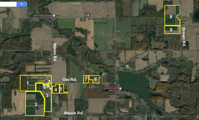
Property Record
3500 Milnes Rd, Hillsdale, MI 49242
NEARBY LISTINGS FOR SALE OR LEASE
-
-
View all Hillsdale listings for sale on LoopNet.com
Property Detail
3500 Milnes Rd
Hillsdale, MI
False
06-013-400-006-13-6-3
N 795 FT OF W1/2 SW FR1/4 EXC N 165 FT OF W 264 FT ALSO EXC N 660 FT OF E 300 FT SEC 18 T6S R2W 22.2
Miscellaneous
Hillsdale
X
Michigan
26059C0179D
95 AC
0
Ann Arbor/Jackson
2025
Other Market Areas
050900
DEMOGRAPHICS near 3500 Milnes Rd
1 Mile
3 Mile
5 Mile
2024 Total Population
333
3,548
14,743
2029 Population
332
3,523
14,582
Pop Growth 2024-2029
(0.30%)
(0.70%)
(1.09%)
Average Age
44
39
39
2024 Total Households
137
1,297
5,735
HH Growth 2024-2029
(0.73%)
(0.69%)
(1.20%)
Median Household Inc
$47,500
$54,368
$51,435
Avg Household Size
2.40
2.30
2.30
2024 Avg HH Vehicles
2.00
2.00
2.00
Median Home Value
$167,391
$154,999
$147,815
Median Year Built
1976
1966
1963
Nearby Places
Map Layers
Map Styles
 Street
 Aerial
- Restaurants
- Banks
- Shops
- Fitness
- Groceries
SALE & LEASE HISTORY
LISTING DATE
SALE/LEASE

Oct 17, 2023
For Sale
Nearby Properties
Address
Land Use
TOTAL SIZE
Lot Size
Zoning
Address
Land Use
TOTAL SIZE
Lot Size
Zoning
77,528 SF
26.75 AC
C1
Address
Land Use
TOTAL SIZE
Lot Size
Zoning
171,597 SF
55.32 AC
C1
Address
Land Use
TOTAL SIZE
Lot Size
Zoning
Address
Land Use
TOTAL SIZE
Lot Size
Zoning
135,240 SF
10 AC
RM1
Address
Land Use
TOTAL SIZE
Lot Size
Zoning
77,009 SF
6.03 AC
C1
Address
Land Use
TOTAL SIZE
Lot Size
Zoning
22,719 SF
1.90 AC
B2
Address
Land Use
TOTAL SIZE
Lot Size
Zoning
47,074 SF
6.62 AC
RM1
Address
Land Use
TOTAL SIZE
Lot Size
Zoning
128,464 SF
23.66 AC
PRF
Address
Land Use
TOTAL SIZE
Lot Size
Zoning
31,104 SF
6.36 AC
C1
Address
Land Use
TOTAL SIZE
Lot Size
Zoning
107,352 SF
2.67 AC
RM1
Address
Land Use
TOTAL SIZE
Lot Size
Zoning
20,696 SF
1.73 AC
C1
Address
Land Use
TOTAL SIZE
Lot Size
Zoning
31,500 SF
25 AC
C1
Address
Land Use
TOTAL SIZE
Lot Size
Zoning
100,000 SF
3.91 AC
RM1
Address
Land Use
TOTAL SIZE
Lot Size
Zoning
4,510 SF
B3
Address
Land Use
TOTAL SIZE
Lot Size
Zoning
114,879 SF
12.47 AC
B3
Address
Land Use
TOTAL SIZE
Lot Size
Zoning
35,457 SF
3.35 AC
C1
Address
Land Use
TOTAL SIZE
Lot Size
Zoning
54,016 SF
4.84 AC
RM1
Address
Land Use
TOTAL SIZE
Lot Size
Zoning
81,225 SF
49.49 AC
I1
Address
Land Use
TOTAL SIZE
Lot Size
Zoning
8,865 SF
1.43 AC
C1
Address
Land Use
TOTAL SIZE
Lot Size
Zoning
0.93 AC
Address
Land Use
TOTAL SIZE
Lot Size
Zoning
Address
Land Use
TOTAL SIZE
Lot Size
Zoning
75,380 SF
5.53 AC
I1
Address
Land Use
TOTAL SIZE
Lot Size
Zoning
35,000 SF
4.73 AC
R1
Address
Land Use
TOTAL SIZE
Lot Size
Zoning
135,067 SF
20.30 AC
I1
Address
Land Use
TOTAL SIZE
Lot Size
Zoning
48,000 SF
3.43 AC
RM1
Address
Land Use
TOTAL SIZE
Lot Size
Zoning
28,192 SF
2.13 AC
RD1
Address
Land Use
TOTAL SIZE
Lot Size
Zoning
32,739 SF
4.54 AC
RM1
Address
Land Use
TOTAL SIZE
Lot Size
Zoning
36,094 SF
3.33 AC
B3
Address
Land Use
TOTAL SIZE
Lot Size
Zoning
17,514 SF
9 AC
Address
Land Use
TOTAL SIZE
Lot Size
Zoning
The World's #1 Commercial Real Estate Marketplace
Connect with us
© 2026 CoStar Group
The information above has been obtained from sources believed reliable. While we do not doubt its accuracy we have not verified it and make no guarantee, warranty or representation about it. It is your responsibility to independently confirm its accuracy and completeness. Any projections, opinions, assumptions, or estimates used are for example only and do not represent the current or future performance of the property. The value of this transaction to you depends on tax and other factors which should be evaluated by your tax, financial, and legal advisors. You and your advisors should conduct a careful, independent investigation of the property to determine to your satisfaction the suitability of the property for your needs.