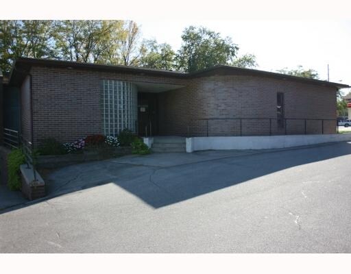
Property Record
3500 Mount Vernon Rd Se, Cedar Rapids, IA 52403

NEARBY LISTINGS FOR SALE OR LEASE
Property Detail
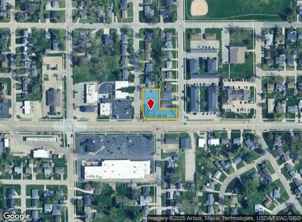
3500 Mount Vernon Rd Se
14243-56007-00000
Mannings 3Rd
Medicalbuilding
MANNINGS 3RD LOTS 6 & 7-EX RD & ALL LOTS 8 & 9
X
Linn
19113C0430F
Iowa
2024
6-9
2025
0.54 AC
001600
Other Market Areas
3,976 SF
Cedar Rapids, IA
DEMOGRAPHICS near 3500 Mount Vernon Rd Se
1 Mile
3 Mile
5 Mile
2024 Total Population
8,038
42,634
116,979
2029 Population
7,923
42,623
116,522
Pop Growth 2024-2029
(1.43%)
(0.03%)
(0.39%)
Average Age
42
40
40
2024 Total Households
3,463
18,516
50,395
HH Growth 2024-2029
(1.47%)
+ 0.02%
(0.40%)
Median Household Inc
$73,388
$58,587
$60,405
Avg Household Size
2.30
2.10
2.20
2024 Avg HH Vehicles
2.00
2.00
2.00
Median Home Value
$175,859
$163,354
$164,481
Median Year Built
1958
1955
1966
Nearby Places
Map Layers
Map Styles
 Street
 Aerial
- Restaurants
- Banks
- Shops
- Fitness
- Groceries
PUBLIC TRANSPORTATION
AIRPORT
The Eastern Iowa
DRIVE
WALK
Distance
The Eastern Iowa
19 min
11.9 mi
Freight Ports
Port Milwaukee
DRIVE
WALK
Distance
Port Milwaukee
289 min
244.0 mi
Nearby Properties
Address
Land Use
TOTAL SIZE
Lot Size
Zoning
Address
Land Use
TOTAL SIZE
Lot Size
Zoning
429,314 SF
14.92 AC
Address
Land Use
TOTAL SIZE
Lot Size
Zoning
355,567 SF
14.60 AC
Address
Land Use
TOTAL SIZE
Lot Size
Zoning
171,842 SF
4.16 AC
Address
Land Use
TOTAL SIZE
Lot Size
Zoning
264,086 SF
21.44 AC
Address
Land Use
TOTAL SIZE
Lot Size
Zoning
218,747 SF
9.45 AC
Address
Land Use
TOTAL SIZE
Lot Size
Zoning
65,970 SF
2.07 AC
Address
Land Use
TOTAL SIZE
Lot Size
Zoning
73,012 SF
2.60 AC
Address
Land Use
TOTAL SIZE
Lot Size
Zoning
276,234 SF
44.53 AC
Address
Land Use
TOTAL SIZE
Lot Size
Zoning
125,013 SF
0.97 AC
Address
Land Use
TOTAL SIZE
Lot Size
Zoning
60,910 SF
2.48 AC
Address
Land Use
TOTAL SIZE
Lot Size
Zoning
180,790 SF
24.39 AC
Address
Land Use
TOTAL SIZE
Lot Size
Zoning
97,612 SF
0.89 AC
Address
Land Use
TOTAL SIZE
Lot Size
Zoning
74,015 SF
6.59 AC
Address
Land Use
TOTAL SIZE
Lot Size
Zoning
67,971 SF
Address
Land Use
TOTAL SIZE
Lot Size
Zoning
220,128 SF
71.19 AC
Address
Land Use
TOTAL SIZE
Lot Size
Zoning
36,803 SF
2.53 AC
Address
Land Use
TOTAL SIZE
Lot Size
Zoning
23,585 SF
1.05 AC
Address
Land Use
TOTAL SIZE
Lot Size
Zoning
80,530 SF
2.96 AC
Address
Land Use
TOTAL SIZE
Lot Size
Zoning
32,855 SF
1.37 AC
Address
Land Use
TOTAL SIZE
Lot Size
Zoning
56,178 SF
0.97 AC
Address
Land Use
TOTAL SIZE
Lot Size
Zoning
45,012 SF
0.85 AC
Address
Land Use
TOTAL SIZE
Lot Size
Zoning
22,400 SF
0.40 AC
Address
Land Use
TOTAL SIZE
Lot Size
Zoning
45,098 SF
3.02 AC
Address
Land Use
TOTAL SIZE
Lot Size
Zoning
39,271 SF
0.66 AC
Address
Land Use
TOTAL SIZE
Lot Size
Zoning
47,710 SF
0.71 AC
Address
Land Use
TOTAL SIZE
Lot Size
Zoning
74,525 SF
5.69 AC
Address
Land Use
TOTAL SIZE
Lot Size
Zoning
43,863 SF
1.86 AC
Address
Land Use
TOTAL SIZE
Lot Size
Zoning
63,234 SF
2.20 AC
Address
Land Use
TOTAL SIZE
Lot Size
Zoning
36,485 SF
5.27 AC
Address
Land Use
TOTAL SIZE
Lot Size
Zoning
17,762 SF
1.56 AC
The World's #1 Commercial Real Estate Marketplace
Connect with us
© 2025 CoStar Group
The information above has been obtained from sources believed reliable. While we do not doubt its accuracy we have not verified it and make no guarantee, warranty or representation about it. It is your responsibility to independently confirm its accuracy and completeness. Any projections, opinions, assumptions, or estimates used are for example only and do not represent the current or future performance of the property. The value of this transaction to you depends on tax and other factors which should be evaluated by your tax, financial, and legal advisors. You and your advisors should conduct a careful, independent investigation of the property to determine to your satisfaction the suitability of the property for your needs.