Property Record
3500 Nw Expressway, Oklahoma City, OK 73112
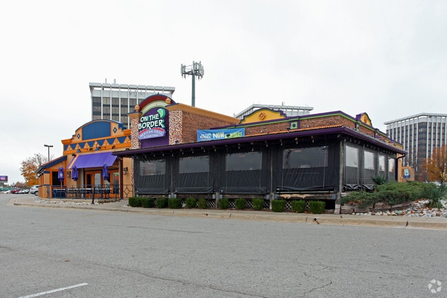


This Property Is For Sale
NEARBY LISTINGS FOR SALE OR LEASE
Property Detail
3500 Nw Expressway
Oklahoma City, OK
Smiths Highland Hills
142754205
SMITHS HIGHLAND HILLS 000 000 BEG 69.08FT NELY OF NW/C LOT 2 BLK 21 SMITHS HIGHLAND HILLS ADD TH NW379.13FT NW176.46FT NW50.33FT N79.80FT NW97.20FT NE227.41FT SE66.03FT SE92.34FT SE55.31FT SWLY6.33FT TH ON CURVE TO LEFT 245.09FT SE38.51FT SE71.19FT S
Restaurantbuilding
Oklahoma
X
Oklahoma
40109C0165H
2
2023
4.26 AC
2024
Northwest
106611
Oklahoma City
7,272 SF
DEMOGRAPHICS near 3500 Nw Expressway
1 Mile
3 Mile
5 Mile
2024 Total Population
12,081
90,954
241,341
2029 Population
12,357
93,213
247,862
Pop Growth 2024-2029
+ 2.28%
+ 2.48%
+ 2.70%
Average Age
40
39
38
2024 Total Households
5,737
40,456
105,330
HH Growth 2024-2029
+ 2.41%
+ 2.60%
+ 2.78%
Median Household Inc
$54,700
$55,198
$52,782
Avg Household Size
2.00
2.20
2.20
2024 Avg HH Vehicles
2.00
2.00
2.00
Median Home Value
$184,491
$178,358
$177,581
Median Year Built
1965
1963
1967
Nearby Places
Map Layers
Map Styles
 Street
 Aerial
- Restaurants
- Banks
- Shops
- Fitness
- Groceries
PUBLIC TRANSPORTATION
COMMUTER RAIL
DRIVE
WALK
Distance
14 min
9.5 mi
AIRPORT
Will Rogers World
DRIVE
WALK
Distance
Will Rogers World
21 min
11.4 mi
Nearby Properties
Address
Land Use
TOTAL SIZE
Lot Size
Zoning
Address
Land Use
TOTAL SIZE
Lot Size
Zoning
819,976 SF
21.87 AC
C-3
Address
Land Use
TOTAL SIZE
Lot Size
Zoning
467,216 SF
66.90 AC
C-3
Address
Land Use
TOTAL SIZE
Lot Size
Zoning
44,519 SF
3.39 AC
SPUD
Address
Land Use
TOTAL SIZE
Lot Size
Zoning
312,308 SF
9.76 AC
C-3
Address
Land Use
TOTAL SIZE
Lot Size
Zoning
90,059 SF
14.99 AC
O-2
Address
Land Use
TOTAL SIZE
Lot Size
Zoning
430,092 SF
17.35 AC
R-4
Address
Land Use
TOTAL SIZE
Lot Size
Zoning
202,147 SF
44.36 AC
PUD
Address
Land Use
TOTAL SIZE
Lot Size
Zoning
485,764 SF
6.05 AC
C-3
Address
Land Use
TOTAL SIZE
Lot Size
Zoning
452,123 SF
5.64 AC
O-2
Address
Land Use
TOTAL SIZE
Lot Size
Zoning
10,922 SF
1.04 AC
SPUD
Address
Land Use
TOTAL SIZE
Lot Size
Zoning
641,860 SF
62.12 AC
R-4
Address
Land Use
TOTAL SIZE
Lot Size
Zoning
28,099 SF
1.21 AC
O-2
Address
Land Use
TOTAL SIZE
Lot Size
Zoning
49,950 SF
3.69 AC
R-1
Address
Land Use
TOTAL SIZE
Lot Size
Zoning
21,111 SF
2.57 AC
R-4
Address
Land Use
TOTAL SIZE
Lot Size
Zoning
347,288 SF
19 AC
C-3
Address
Land Use
TOTAL SIZE
Lot Size
Zoning
29,274 SF
0.93 AC
C-3
Address
Land Use
TOTAL SIZE
Lot Size
Zoning
244,699 SF
11.83 AC
C-3
Address
Land Use
TOTAL SIZE
Lot Size
Zoning
681,708 SF
20.54 AC
C-3
Address
Land Use
TOTAL SIZE
Lot Size
Zoning
697,098 SF
88.91 AC
C-3
Address
Land Use
TOTAL SIZE
Lot Size
Zoning
164,880 SF
8.95 AC
O-2
Address
Land Use
TOTAL SIZE
Lot Size
Zoning
285,771 SF
8.64 AC
PUD
Address
Land Use
TOTAL SIZE
Lot Size
Zoning
69,370 SF
O-2
Address
Land Use
TOTAL SIZE
Lot Size
Zoning
1 SF
3.72 AC
C-3
Address
Land Use
TOTAL SIZE
Lot Size
Zoning
327,372 SF
14.79 AC
R-4
Address
Land Use
TOTAL SIZE
Lot Size
Zoning
167,057 SF
2.62 AC
PUD
Address
Land Use
TOTAL SIZE
Lot Size
Zoning
370,066 SF
6.83 AC
O-2
Address
Land Use
TOTAL SIZE
Lot Size
Zoning
14,720 SF
0.81 AC
C-3
Address
Land Use
TOTAL SIZE
Lot Size
Zoning
259,024 SF
28.32 AC
R-4
Address
Land Use
TOTAL SIZE
Lot Size
Zoning
220,766 SF
17.65 AC
PUD
Address
Land Use
TOTAL SIZE
Lot Size
Zoning
66,965 SF
14.76 AC
SPUD
The World's #1 Commercial Real Estate Marketplace
Connect with us
© 2026 CoStar Group
The information above has been obtained from sources believed reliable. While we do not doubt its accuracy we have not verified it and make no guarantee, warranty or representation about it. It is your responsibility to independently confirm its accuracy and completeness. Any projections, opinions, assumptions, or estimates used are for example only and do not represent the current or future performance of the property. The value of this transaction to you depends on tax and other factors which should be evaluated by your tax, financial, and legal advisors. You and your advisors should conduct a careful, independent investigation of the property to determine to your satisfaction the suitability of the property for your needs.