Property Record
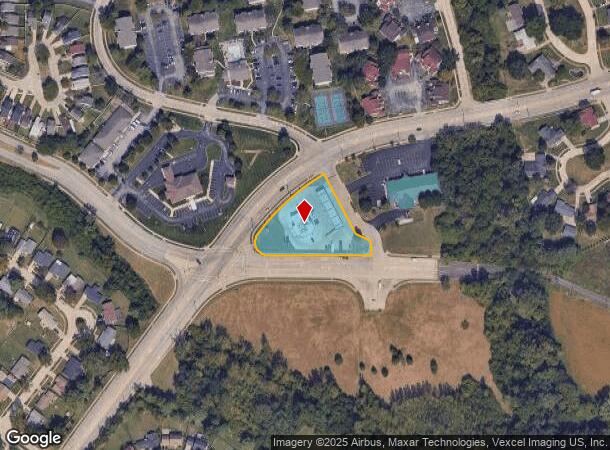
3500 Patterson Rd, Florissant, MO 63031
NEARBY LISTINGS FOR SALE OR LEASE
Property Detail
3500 Patterson Rd
St. Louis, MO-IL
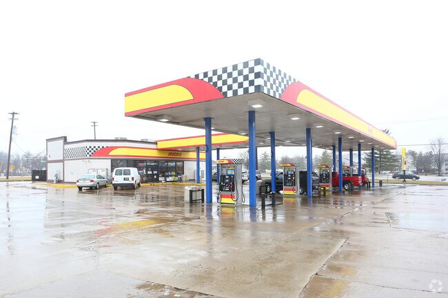
Hucks Corner
06J-63-0901
HUCKS CORNER LOT 1
Servicestation
St. Louis
X
Missouri
29183C0325G
1
2024
1.19 AC
2025
North County
210924
St. Louis
3,321 SF
DEMOGRAPHICS near 3500 Patterson Rd
1 Mile
3 Mile
5 Mile
2024 Total Population
13,280
73,244
135,697
2029 Population
12,953
71,608
132,930
Pop Growth 2024-2029
(2.46%)
(2.23%)
(2.04%)
Average Age
40
41
40
2024 Total Households
4,957
28,357
53,959
HH Growth 2024-2029
(2.48%)
(2.27%)
(2.08%)
Median Household Inc
$74,685
$70,230
$62,949
Avg Household Size
2.60
2.50
2.40
2024 Avg HH Vehicles
2.00
2.00
2.00
Median Home Value
$164,234
$154,584
$149,021
Median Year Built
1974
1967
1966
Nearby Places
Map Layers
Map Styles
 Street
 Aerial
- Restaurants
- Banks
- Shops
- Fitness
- Groceries
PUBLIC TRANSPORTATION
COMMUTER RAIL
Lambert Airport East Terminal (Lambert Airport Shiloh-Scott - St. Louis MetroLink (MetroLink))
DRIVE
WALK
Distance
Lambert Airport East Terminal (Lambert Airport Shiloh-Scott - St. Louis MetroLink (MetroLink))
16 min
8.4 mi
Lambert Airport Main Terminal (Lambert Airport Shiloh-Scott - St. Louis MetroLink (MetroLink))
DRIVE
WALK
Distance
Lambert Airport Main Terminal (Lambert Airport Shiloh-Scott - St. Louis MetroLink (MetroLink))
18 min
8.9 mi
AIRPORT
St Louis Lambert International
DRIVE
WALK
Distance
St Louis Lambert International
15 min
6.8 mi
Freight Ports
Port Milwaukee
DRIVE
WALK
Distance
Port Milwaukee
426 min
374.5 mi
Nearby Properties
Address
Land Use
TOTAL SIZE
Lot Size
Zoning
Address
Land Use
TOTAL SIZE
Lot Size
Zoning
47,184 SF
71.66 AC
R4
Address
Land Use
TOTAL SIZE
Lot Size
Zoning
71.29 AC
24R4
Address
Land Use
TOTAL SIZE
Lot Size
Zoning
296,795 SF
286.21 AC
C-8
Address
Land Use
TOTAL SIZE
Lot Size
Zoning
15.37 AC
R
Address
Land Use
TOTAL SIZE
Lot Size
Zoning
271,184 SF
13.67 AC
B3
Address
Land Use
TOTAL SIZE
Lot Size
Zoning
93,136 SF
108.76 AC
Address
Land Use
TOTAL SIZE
Lot Size
Zoning
354,790 SF
22.46 AC
B6
Address
Land Use
TOTAL SIZE
Lot Size
Zoning
21.29 AC
24R4
Address
Land Use
TOTAL SIZE
Lot Size
Zoning
2,429 SF
79.10 AC
NU
Address
Land Use
TOTAL SIZE
Lot Size
Zoning
320,176 SF
9.83 AC
24MFD
Address
Land Use
TOTAL SIZE
Lot Size
Zoning
387,158 SF
34.19 AC
R6
Address
Land Use
TOTAL SIZE
Lot Size
Zoning
169,426 SF
26.38 AC
R1
Address
Land Use
TOTAL SIZE
Lot Size
Zoning
1,560 SF
12.84 AC
R4
Address
Land Use
TOTAL SIZE
Lot Size
Zoning
999 SF
21.20 AC
R
Address
Land Use
TOTAL SIZE
Lot Size
Zoning
17.26 AC
24R4
Address
Land Use
TOTAL SIZE
Lot Size
Zoning
6.20 AC
24R4
Address
Land Use
TOTAL SIZE
Lot Size
Zoning
193,344 SF
14.37 AC
24MFD
Address
Land Use
TOTAL SIZE
Lot Size
Zoning
134,837 SF
11.43 AC
R4
Address
Land Use
TOTAL SIZE
Lot Size
Zoning
90,796 SF
8.62 AC
B3
Address
Land Use
TOTAL SIZE
Lot Size
Zoning
25,394 SF
67.31 AC
M2
Address
Land Use
TOTAL SIZE
Lot Size
Zoning
12.83 AC
24R4
Address
Land Use
TOTAL SIZE
Lot Size
Zoning
128,455 SF
12.40 AC
24B3
Address
Land Use
TOTAL SIZE
Lot Size
Zoning
146,186 SF
8.24 AC
R4
Address
Land Use
TOTAL SIZE
Lot Size
Zoning
1,797 SF
23.66 AC
NU
Address
Land Use
TOTAL SIZE
Lot Size
Zoning
93,504 SF
12.16 AC
24R4
Address
Land Use
TOTAL SIZE
Lot Size
Zoning
106,935 SF
8.25 AC
24B5
Address
Land Use
TOTAL SIZE
Lot Size
Zoning
93,165 SF
7.31 AC
24B3
Address
Land Use
TOTAL SIZE
Lot Size
Zoning
16.58 AC
24R4
Address
Land Use
TOTAL SIZE
Lot Size
Zoning
136,874 SF
13.18 AC
R1
Address
Land Use
TOTAL SIZE
Lot Size
Zoning
97,649 SF
15.38 AC
B3
The World's #1 Commercial Real Estate Marketplace
Connect with us
© 2026 CoStar Group
The information above has been obtained from sources believed reliable. While we do not doubt its accuracy we have not verified it and make no guarantee, warranty or representation about it. It is your responsibility to independently confirm its accuracy and completeness. Any projections, opinions, assumptions, or estimates used are for example only and do not represent the current or future performance of the property. The value of this transaction to you depends on tax and other factors which should be evaluated by your tax, financial, and legal advisors. You and your advisors should conduct a careful, independent investigation of the property to determine to your satisfaction the suitability of the property for your needs.