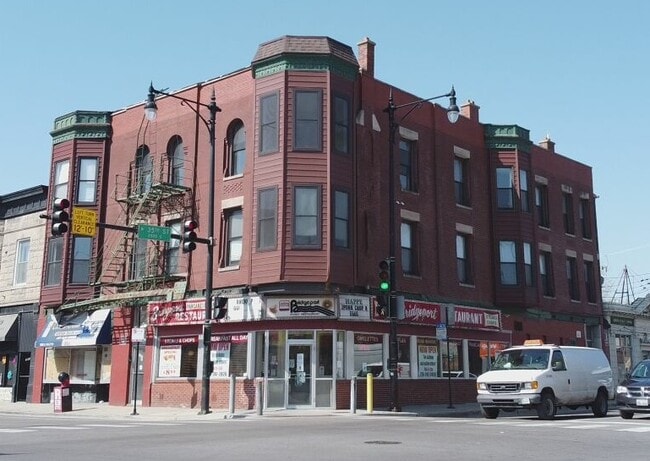
Property Record
3500 S Halsted St, Chicago, IL 60609


NEARBY LISTINGS FOR SALE OR LEASE
Property Detail
3500 S Halsted St
Chicago-Naperville-Elgin, IL-IN
Gage Lemoyne Hubbard
17-32-404-015-0000
(GAGE) (LEMOYNE) (HUBBARD) & OTHERS SUB OF EH SE SEC 32-39-14
Commercialbuilding
Cook
X
Illinois
17031C0509J
1,2
2023
0.18 AC
2025
Bridgeport
839900
Chicago
3,240 SF
DEMOGRAPHICS near 3500 S Halsted St
1 Mile
3 Mile
5 Mile
2024 Total Population
30,594
283,970
811,923
2029 Population
28,401
268,991
778,173
Pop Growth 2024-2029
(7.17%)
(5.27%)
(4.16%)
Average Age
40
37
37
2024 Total Households
12,152
116,928
348,378
HH Growth 2024-2029
(7.61%)
(5.06%)
(3.65%)
Median Household Inc
$63,431
$57,009
$65,274
Avg Household Size
2.40
2.30
2.20
2024 Avg HH Vehicles
1.00
1.00
1.00
Median Home Value
$385,752
$328,723
$333,473
Median Year Built
1948
1960
1965
Nearby Places
Map Layers
Map Styles
 Street
 Aerial
- Restaurants
- Banks
- Shops
- Fitness
- Groceries
PUBLIC TRANSPORTATION
TRANSIT/SUBWAY
Sox/35th Street Station (Red Line - Chicago Transit Authority "L" Trains (The "L"))
DRIVE
WALK
Distance
Sox/35th Street Station (Red Line - Chicago Transit Authority "L" Trains (The "L"))
7 min
18 min
0.9 mi
COMMUTER RAIL
DRIVE
WALK
Distance
2 min
18 min
0.9 mi
Halsted Station (Burlington Northern-Santa Fe Railway Line - Northeast Illinois Regional Commuter Railroad (Metra))
DRIVE
WALK
Distance
Halsted Station (Burlington Northern-Santa Fe Railway Line - Northeast Illinois Regional Commuter Railroad (Metra))
6 min
2.2 mi
AIRPORT
Chicago Midway International
DRIVE
WALK
Distance
Chicago Midway International
13 min
6.7 mi
Chicago O'Hare International
DRIVE
WALK
Distance
Chicago O'Hare International
33 min
20.5 mi
SALE & LEASE HISTORY
LISTING DATE
SALE/LEASE

Nov 16, 2021
For Sale
Mar 05, 2021
For Lease
Jun 21, 2022
For Lease
Nearby Properties
Address
Land Use
TOTAL SIZE
Lot Size
Zoning
Address
Land Use
TOTAL SIZE
Lot Size
Zoning
1,215,367 SF
3.76 AC
PD 675
Address
Land Use
TOTAL SIZE
Lot Size
Zoning
590,844 SF
0.80 AC
PD 26
Address
Land Use
TOTAL SIZE
Lot Size
Zoning
1,252,885 SF
0.99 AC
PD 499
Address
Land Use
TOTAL SIZE
Lot Size
Zoning
1,081,939 SF
0.68 AC
PD 1323
Address
Land Use
TOTAL SIZE
Lot Size
Zoning
662,088 SF
4.91 AC
PD 504
Address
Land Use
TOTAL SIZE
Lot Size
Zoning
474,979 SF
29.67 AC
PD 553
Address
Land Use
TOTAL SIZE
Lot Size
Zoning
979,674 SF
6.01 AC
PD 924
Address
Land Use
TOTAL SIZE
Lot Size
Zoning
717,953 SF
1.37 AC
DX-16
Address
Land Use
TOTAL SIZE
Lot Size
Zoning
626,055 SF
1.86 AC
PD 523
Address
Land Use
TOTAL SIZE
Lot Size
Zoning
408,203 SF
2.02 AC
DS-5
Address
Land Use
TOTAL SIZE
Lot Size
Zoning
0.85 AC
DS-3
Address
Land Use
TOTAL SIZE
Lot Size
Zoning
325,558 SF
Address
Land Use
TOTAL SIZE
Lot Size
Zoning
Address
Land Use
TOTAL SIZE
Lot Size
Zoning
587,125 SF
1.10 AC
PD 1298
Address
Land Use
TOTAL SIZE
Lot Size
Zoning
496,992 SF
1.86 AC
PD 523
Address
Land Use
TOTAL SIZE
Lot Size
Zoning
4.11 AC
M2-3
Address
Land Use
TOTAL SIZE
Lot Size
Zoning
611,160 SF
2.36 AC
PD 523
Address
Land Use
TOTAL SIZE
Lot Size
Zoning
460,333 SF
2.62 AC
C2-3
Address
Land Use
TOTAL SIZE
Lot Size
Zoning
136,720 SF
0.54 AC
PD 1
Address
Land Use
TOTAL SIZE
Lot Size
Zoning
728,610 SF
PD 225
Address
Land Use
TOTAL SIZE
Lot Size
Zoning
542,503 SF
7.78 AC
PD 523
Address
Land Use
TOTAL SIZE
Lot Size
Zoning
24,100 SF
0.31 AC
DX-12
Address
Land Use
TOTAL SIZE
Lot Size
Zoning
0.35 AC
PD 1317
Address
Land Use
TOTAL SIZE
Lot Size
Zoning
548,210 SF
1.11 AC
PD 681
Address
Land Use
TOTAL SIZE
Lot Size
Zoning
Address
Land Use
TOTAL SIZE
Lot Size
Zoning
508,816 SF
1.11 AC
DX-7,PD 49
Address
Land Use
TOTAL SIZE
Lot Size
Zoning
0.38 AC
PD 1209
Address
Land Use
TOTAL SIZE
Lot Size
Zoning
552,300 SF
0.69 AC
PMD 11
Address
Land Use
TOTAL SIZE
Lot Size
Zoning
111,322 SF
1 AC
DS-5
Address
Land Use
TOTAL SIZE
Lot Size
Zoning
308,182 SF
2 AC
PD 225
The World's #1 Commercial Real Estate Marketplace
Connect with us
© 2026 CoStar Group
The information above has been obtained from sources believed reliable. While we do not doubt its accuracy we have not verified it and make no guarantee, warranty or representation about it. It is your responsibility to independently confirm its accuracy and completeness. Any projections, opinions, assumptions, or estimates used are for example only and do not represent the current or future performance of the property. The value of this transaction to you depends on tax and other factors which should be evaluated by your tax, financial, and legal advisors. You and your advisors should conduct a careful, independent investigation of the property to determine to your satisfaction the suitability of the property for your needs.