Property Record
3500 Seneca St, Baker, LA 70714


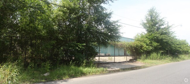
Property Detail
3500 Seneca St
Baton Rouge, LA
WARD: 1-1, SUBDIVISION: PRESCOTT, NELLIE DOUGHERTY TRACT, LOT: A-1. LOT A-1, BEING A PORTION OF LOT 5 OF A SUBDIVISION OF THE
00013021
E BATON ROUGE
Storesoffices
Louisiana
B and X Area of moderate flood hazard, usually the area between the limits of the 100-year and 500-year floods.
a-1
2025
2.24 AC
2025
East Baton Rouge Parish North
004205
Baton Rouge
NEARBY LISTINGS FOR SALE OR LEASE
DEMOGRAPHICS near 3500 Seneca St
1 mile
3 mile
5 mile
2025 Total Population
14,501
77,122
165,041
2030 Population
14,735
77,926
166,066
Pop Growth 2025-2030
+ 1.61%
+ 1.04%
+ 0.62%
Average Age
39
38
37
2025 Total Households
5,485
32,029
65,449
HH Growth 2025-2030
+ 1.64%
+ 1.01%
+ 0.68%
Median Household Inc
$30,536
$33,661
$39,797
Avg Household Size
2.50
2.30
2.30
2025 Avg HH Vehicles
1.00
1.00
1.00
Median Home Value
$77,160
$154,726
$187,232
Median Year Built
1960
1965
1971
Nearby Places
Map Layers
Map Styles
 Street
 Aerial
Layers
 Traffic
 Biking
Places
Listings with unknown addresses are not visible on the map
- Restaurants
- Banks
- Shops
- Fitness
- Groceries
PUBLIC TRANSPORTATION
AIRPORT
Baton Rouge Metro Ryan Field
Drive
Walk
Distance
Baton Rouge Metro Ryan Field
9 min
4.5 mi
Freight Ports
Port of Greater Baton Rouge
Drive
Walk
Distance
Port of Greater Baton Rouge
14 min
6.8 mi
SALE & LEASE HISTORY
LISTING DATE
SALE/LEASE

Nov 28, 2017
For Lease
Nov 28, 2017
For Sale
Nearby Properties
Address
Land Use
TOTAL SIZE
Lot Size
Zoning
Address
Land Use
TOTAL SIZE
Lot Size
Zoning
Address
Land Use
TOTAL SIZE
Lot Size
Zoning
Address
Land Use
TOTAL SIZE
Lot Size
Zoning
Address
Land Use
TOTAL SIZE
Lot Size
Zoning
332,000 SF
1.42 AC
Address
Land Use
TOTAL SIZE
Lot Size
Zoning
290,620 SF
1.76 AC
Address
Land Use
TOTAL SIZE
Lot Size
Zoning
Address
Land Use
TOTAL SIZE
Lot Size
Zoning
8.83 AC
Address
Land Use
TOTAL SIZE
Lot Size
Zoning
50,025 SF
6.68 AC
Address
Land Use
TOTAL SIZE
Lot Size
Zoning
25,369 SF
1,200 AC
Address
Land Use
TOTAL SIZE
Lot Size
Zoning
55,755 SF
9.29 AC
Address
Land Use
TOTAL SIZE
Lot Size
Zoning
244,833 SF
0.84 AC
Address
Land Use
TOTAL SIZE
Lot Size
Zoning
147,124 SF
Address
Land Use
TOTAL SIZE
Lot Size
Zoning
350,000 SF
1.20 AC
Address
Land Use
TOTAL SIZE
Lot Size
Zoning
100,000 SF
Address
Land Use
TOTAL SIZE
Lot Size
Zoning
Address
Land Use
TOTAL SIZE
Lot Size
Zoning
207,577 SF
0.93 AC
Address
Land Use
TOTAL SIZE
Lot Size
Zoning
149,372 SF
0.19 AC
Address
Land Use
TOTAL SIZE
Lot Size
Zoning
166,222 SF
1.06 AC
Address
Land Use
TOTAL SIZE
Lot Size
Zoning
0.19 AC
Address
Land Use
TOTAL SIZE
Lot Size
Zoning
62,503 SF
100 AC
Address
Land Use
TOTAL SIZE
Lot Size
Zoning
Address
Land Use
TOTAL SIZE
Lot Size
Zoning
14.27 AC
Address
Land Use
TOTAL SIZE
Lot Size
Zoning
12.23 AC
Address
Land Use
TOTAL SIZE
Lot Size
Zoning
Address
Land Use
TOTAL SIZE
Lot Size
Zoning
81,137 SF
2.99 AC
Address
Land Use
TOTAL SIZE
Lot Size
Zoning
78,100 SF
0.26 AC
Address
Land Use
TOTAL SIZE
Lot Size
Zoning
115,430 SF
24.42 AC
Address
Land Use
TOTAL SIZE
Lot Size
Zoning
11.50 AC
Address
Land Use
TOTAL SIZE
Lot Size
Zoning
Address
Land Use
TOTAL SIZE
Lot Size
Zoning
The World's #1 Commercial Real Estate Marketplace
Connect with us
© 2026 CoStar Group
The information above has been obtained from sources believed reliable. While we do not doubt its accuracy we have not verified it and make no guarantee, warranty or representation about it. It is your responsibility to independently confirm its accuracy and completeness. Any projections, opinions, assumptions, or estimates used are for example only and do not represent the current or future performance of the property. The value of this transaction to you depends on tax and other factors which should be evaluated by your tax, financial, and legal advisors. You and your advisors should conduct a careful, independent investigation of the property to determine to your satisfaction the suitability of the property for your needs.