Property Record
3500 Tennessee Rd, Texarkana, AR 71854


NEARBY LISTINGS FOR SALE OR LEASE
-
-
View all Texarkana listings for sale on LoopNet.com
Property Detail
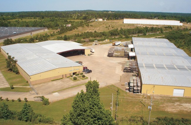
3500 Tennessee Rd
00374200
33-15S-28W
Commercialnec
PT NW NE
X
Miller
48037C0370E
Arkansas
2025
15.55 AC
2025
Arkansas South Area
020500
Other Market Areas
66,268 SF
Texarkana, TX-AR
DEMOGRAPHICS near 3500 Tennessee Rd
1 Mile
3 Mile
5 Mile
2024 Total Population
2,181
20,758
52,649
2029 Population
2,207
21,060
52,955
Pop Growth 2024-2029
+ 1.19%
+ 1.45%
+ 0.58%
Average Age
38
39
39
2024 Total Households
838
7,933
21,034
HH Growth 2024-2029
+ 1.31%
+ 1.58%
+ 0.58%
Median Household Inc
$29,620
$37,713
$40,309
Avg Household Size
2.40
2.30
2.30
2024 Avg HH Vehicles
1.00
2.00
2.00
Median Home Value
$142,142
$115,279
$126,050
Median Year Built
1990
1974
1976
Nearby Places
Map Layers
Map Styles
 Street
 Aerial
- Restaurants
- Banks
- Shops
- Fitness
- Groceries
PUBLIC TRANSPORTATION
COMMUTER RAIL
Texarkana Amtrak Station (Texas Eagle - Amtrak)
DRIVE
WALK
Distance
Texarkana Amtrak Station (Texas Eagle - Amtrak)
6 min
3.3 mi
AIRPORT
Texarkana Regional-Webb Field
DRIVE
WALK
Distance
Texarkana Regional-Webb Field
11 min
4.6 mi
Freight Ports
Port of Shreveport
DRIVE
WALK
Distance
Port of Shreveport
103 min
91.7 mi
Nearby Properties
Address
Land Use
TOTAL SIZE
Lot Size
Zoning
Address
Land Use
TOTAL SIZE
Lot Size
Zoning
1,896,910 SF
46.19 AC
Address
Land Use
TOTAL SIZE
Lot Size
Zoning
Address
Land Use
TOTAL SIZE
Lot Size
Zoning
1,896,910 SF
Address
Land Use
TOTAL SIZE
Lot Size
Zoning
32.42 AC
Address
Land Use
TOTAL SIZE
Lot Size
Zoning
102,614 SF
0.89 AC
Address
Land Use
TOTAL SIZE
Lot Size
Zoning
100,000 SF
5.92 AC
Address
Land Use
TOTAL SIZE
Lot Size
Zoning
74,246 SF
1.34 AC
Address
Land Use
TOTAL SIZE
Lot Size
Zoning
55,033 SF
Address
Land Use
TOTAL SIZE
Lot Size
Zoning
4.43 AC
Address
Land Use
TOTAL SIZE
Lot Size
Zoning
270,796 SF
33.10 AC
Address
Land Use
TOTAL SIZE
Lot Size
Zoning
185,060 SF
Address
Land Use
TOTAL SIZE
Lot Size
Zoning
28,480 SF
0.96 AC
Address
Land Use
TOTAL SIZE
Lot Size
Zoning
179,723 SF
36.84 AC
Address
Land Use
TOTAL SIZE
Lot Size
Zoning
26,696 SF
1.29 AC
Address
Land Use
TOTAL SIZE
Lot Size
Zoning
2.07 AC
Address
Land Use
TOTAL SIZE
Lot Size
Zoning
47,776 SF
8 AC
Address
Land Use
TOTAL SIZE
Lot Size
Zoning
26,721 SF
0.32 AC
Address
Land Use
TOTAL SIZE
Lot Size
Zoning
90,160 SF
1.96 AC
Address
Land Use
TOTAL SIZE
Lot Size
Zoning
211,666 SF
15.11 AC
Address
Land Use
TOTAL SIZE
Lot Size
Zoning
0.48 AC
Address
Land Use
TOTAL SIZE
Lot Size
Zoning
14,086 SF
0.45 AC
Address
Land Use
TOTAL SIZE
Lot Size
Zoning
19,456 SF
0.96 AC
Address
Land Use
TOTAL SIZE
Lot Size
Zoning
15,940 SF
13.43 AC
Address
Land Use
TOTAL SIZE
Lot Size
Zoning
2,103 SF
6.55 AC
Address
Land Use
TOTAL SIZE
Lot Size
Zoning
11,960 SF
0.96 AC
Address
Land Use
TOTAL SIZE
Lot Size
Zoning
10,327 SF
0.48 AC
Address
Land Use
TOTAL SIZE
Lot Size
Zoning
15,002 SF
0.96 AC
Address
Land Use
TOTAL SIZE
Lot Size
Zoning
13,337 SF
0.48 AC
Address
Land Use
TOTAL SIZE
Lot Size
Zoning
3,678 SF
46.73 AC
Address
Land Use
TOTAL SIZE
Lot Size
Zoning
125,568 SF
16.70 AC
The World's #1 Commercial Real Estate Marketplace
Connect with us
© 2025 CoStar Group
The information above has been obtained from sources believed reliable. While we do not doubt its accuracy we have not verified it and make no guarantee, warranty or representation about it. It is your responsibility to independently confirm its accuracy and completeness. Any projections, opinions, assumptions, or estimates used are for example only and do not represent the current or future performance of the property. The value of this transaction to you depends on tax and other factors which should be evaluated by your tax, financial, and legal advisors. You and your advisors should conduct a careful, independent investigation of the property to determine to your satisfaction the suitability of the property for your needs.