Property Record
35000 Warren Rd, Westland, MI 48185
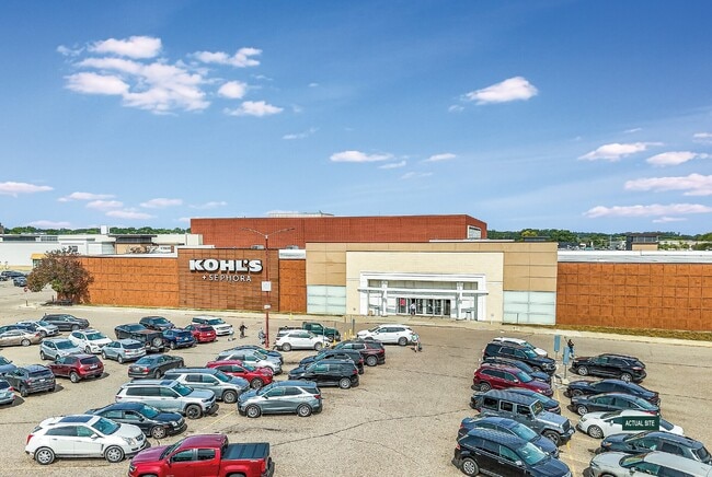
This Property Is For Sale
NEARBY LISTINGS FOR SALE OR LEASE
Property Detail
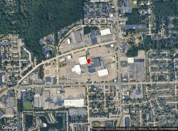
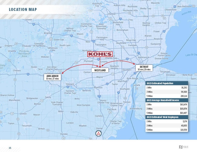
35000 Warren Rd
56-015-99-0011-704
PART OF THE SW 1/4 OF SEC 4 T2S R9E, CITY OF WESTLAND, WAYNE COUNTY, MICHIGAN MORE PARTICULARLY DESCRIBED AS COMMEN AT THE SW COR OF SAID SEC 4; TH N 01D 26M 11S W 60.02 FT TO A POINT ON THE N LINE OF WARREN ROAD (120 FT WIDE); TH S 89D 57M 15S E 445
Regionalshoppingcenterormallwithanchorstore
Wayne
X
Michigan
26163C0210E
8.35 AC
2025
Southern I-275 Corridor
2025
Detroit
565301
Detroit-Warren-Dearborn, MI
90,306 SF
DEMOGRAPHICS near 35000 Warren Rd
1 Mile
3 Mile
5 Mile
2024 Total Population
14,972
90,550
257,145
2029 Population
14,481
86,846
246,740
Pop Growth 2024-2029
(3.28%)
(4.09%)
(4.05%)
Average Age
42
42
41
2024 Total Households
7,855
40,582
107,034
HH Growth 2024-2029
(3.30%)
(4.11%)
(4.07%)
Median Household Inc
$42,735
$64,706
$71,171
Avg Household Size
1.90
2.20
2.30
2024 Avg HH Vehicles
1.00
2.00
2.00
Median Home Value
$159,081
$170,996
$195,064
Median Year Built
1974
1965
1965
Nearby Places
Map Layers
Map Styles
 Street
 Aerial
- Restaurants
- Banks
- Shops
- Fitness
- Groceries
PUBLIC TRANSPORTATION
AIRPORT
Detroit Metro Wayne County
DRIVE
WALK
Distance
Detroit Metro Wayne County
25 min
17.5 mi
Windsor International
DRIVE
WALK
Distance
Windsor International
51 min
32.5 mi
Freight Ports
Port of Toledo
DRIVE
WALK
Distance
Port of Toledo
75 min
59.1 mi
Nearby Properties
Address
Land Use
TOTAL SIZE
Lot Size
Zoning
Address
Land Use
TOTAL SIZE
Lot Size
Zoning
741,173 SF
63.81 AC
Address
Land Use
TOTAL SIZE
Lot Size
Zoning
3,733,882 SF
183.17 AC
M-2
Address
Land Use
TOTAL SIZE
Lot Size
Zoning
1,005,040 SF
Address
Land Use
TOTAL SIZE
Lot Size
Zoning
37.30 AC
MR
Address
Land Use
TOTAL SIZE
Lot Size
Zoning
1,316,911 SF
72.87 AC
M-1
Address
Land Use
TOTAL SIZE
Lot Size
Zoning
408,122 SF
23.31 AC
MR
Address
Land Use
TOTAL SIZE
Lot Size
Zoning
352,514 SF
26.40 AC
Address
Land Use
TOTAL SIZE
Lot Size
Zoning
480,910 SF
26.32 AC
Address
Land Use
TOTAL SIZE
Lot Size
Zoning
395,148 SF
9.67 AC
Address
Land Use
TOTAL SIZE
Lot Size
Zoning
249,795 SF
21.17 AC
Address
Land Use
TOTAL SIZE
Lot Size
Zoning
176,396 SF
11.76 AC
Address
Land Use
TOTAL SIZE
Lot Size
Zoning
188,958 SF
7.71 AC
Address
Land Use
TOTAL SIZE
Lot Size
Zoning
286,188 SF
40.21 AC
Address
Land Use
TOTAL SIZE
Lot Size
Zoning
285,136 SF
15.28 AC
Address
Land Use
TOTAL SIZE
Lot Size
Zoning
172,094 SF
11.84 AC
M-2
Address
Land Use
TOTAL SIZE
Lot Size
Zoning
16.03 AC
MR
Address
Land Use
TOTAL SIZE
Lot Size
Zoning
206,130 SF
14.12 AC
Address
Land Use
TOTAL SIZE
Lot Size
Zoning
243,371 SF
16.04 AC
Address
Land Use
TOTAL SIZE
Lot Size
Zoning
269,649 SF
18.27 AC
LI-1
Address
Land Use
TOTAL SIZE
Lot Size
Zoning
Address
Land Use
TOTAL SIZE
Lot Size
Zoning
76,430 SF
13.61 AC
C-3
Address
Land Use
TOTAL SIZE
Lot Size
Zoning
177,268 SF
17.11 AC
Address
Land Use
TOTAL SIZE
Lot Size
Zoning
127,811 SF
6.95 AC
M-2
Address
Land Use
TOTAL SIZE
Lot Size
Zoning
197,774 SF
11.72 AC
Address
Land Use
TOTAL SIZE
Lot Size
Zoning
145,232 SF
7.16 AC
M-2
Address
Land Use
TOTAL SIZE
Lot Size
Zoning
204,978 SF
10.28 AC
LI-1
Address
Land Use
TOTAL SIZE
Lot Size
Zoning
232,858 SF
39.67 AC
Address
Land Use
TOTAL SIZE
Lot Size
Zoning
11.38 AC
MR
Address
Land Use
TOTAL SIZE
Lot Size
Zoning
170,275 SF
16.53 AC
Address
Land Use
TOTAL SIZE
Lot Size
Zoning
238,980 SF
18.89 AC
The World's #1 Commercial Real Estate Marketplace
Connect with us
© 2026 CoStar Group
The information above has been obtained from sources believed reliable. While we do not doubt its accuracy we have not verified it and make no guarantee, warranty or representation about it. It is your responsibility to independently confirm its accuracy and completeness. Any projections, opinions, assumptions, or estimates used are for example only and do not represent the current or future performance of the property. The value of this transaction to you depends on tax and other factors which should be evaluated by your tax, financial, and legal advisors. You and your advisors should conduct a careful, independent investigation of the property to determine to your satisfaction the suitability of the property for your needs.