Property Record
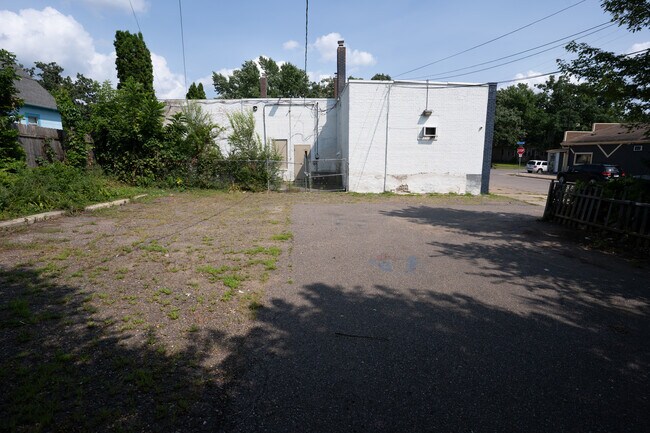
3501 Penn Ave N, Minneapolis, MN 55412


This Property Is For Sale
NEARBY LISTINGS FOR SALE OR LEASE
Property Detail
3501 Penn Ave N
Minneapolis-St. Paul-Bloomington, MN-WI
Utopia
08-029-24-11-0082
LOT 005 A UTOPIA S 1/2 OF E 1/2 INCL ADJ 7 FT OF PENN AVE N VAC EXCEPT ALLEY 59.8 X 129.5
Commercialnec
Hennepin
X
Minnesota
27053C0218F
5
2024
0.18 AC
2024
Brookdale
100700
Minneapolis/St Paul
6,571 SF
DEMOGRAPHICS near 3501 Penn Ave N
1 Mile
3 Mile
5 Mile
2024 Total Population
23,848
130,445
411,792
2029 Population
23,321
127,855
407,074
Pop Growth 2024-2029
(2.21%)
(1.99%)
(1.15%)
Average Age
35
37
37
2024 Total Households
8,169
50,899
178,525
HH Growth 2024-2029
(2.36%)
(2.05%)
(1.10%)
Median Household Inc
$61,201
$68,659
$66,727
Avg Household Size
2.70
2.40
2.10
2024 Avg HH Vehicles
2.00
2.00
1.00
Median Home Value
$209,150
$251,049
$276,684
Median Year Built
1947
1955
1965
Nearby Places
Map Layers
Map Styles
 Street
 Aerial
- Restaurants
- Banks
- Shops
- Fitness
- Groceries
PUBLIC TRANSPORTATION
COMMUTER RAIL
Target Field Station (Northstar Corridor - Northstar Commuter Rail)
DRIVE
WALK
Distance
Target Field Station (Northstar Corridor - Northstar Commuter Rail)
10 min
3.7 mi
Fridley Station (Northstar Corridor - Northstar Commuter Rail)
DRIVE
WALK
Distance
Fridley Station (Northstar Corridor - Northstar Commuter Rail)
12 min
6.2 mi
AIRPORT
Minneapolis-St Paul International/Wold-Chamberlain
DRIVE
WALK
Distance
Minneapolis-St Paul International/Wold-Chamberlain
30 min
15.7 mi
Freight Ports
Port Milwaukee
DRIVE
WALK
Distance
Port Milwaukee
385 min
344.0 mi
Nearby Properties
Address
Land Use
TOTAL SIZE
Lot Size
Zoning
Address
Land Use
TOTAL SIZE
Lot Size
Zoning
1,021,060 SF
1.71 AC
B4S-2
Address
Land Use
TOTAL SIZE
Lot Size
Zoning
2.67 AC
C3A
Address
Land Use
TOTAL SIZE
Lot Size
Zoning
1 SF
69.72 AC
I3
Address
Land Use
TOTAL SIZE
Lot Size
Zoning
341,894 SF
2.62 AC
R6
Address
Land Use
TOTAL SIZE
Lot Size
Zoning
502,092 SF
1.16 AC
B4N
Address
Land Use
TOTAL SIZE
Lot Size
Zoning
399,841 SF
2.51 AC
C3A
Address
Land Use
TOTAL SIZE
Lot Size
Zoning
405,028 SF
B4N
Address
Land Use
TOTAL SIZE
Lot Size
Zoning
225,845 SF
1 AC
C3A
Address
Land Use
TOTAL SIZE
Lot Size
Zoning
Address
Land Use
TOTAL SIZE
Lot Size
Zoning
251,080 SF
1.27 AC
B4S-1
Address
Land Use
TOTAL SIZE
Lot Size
Zoning
458,954 SF
1.73 AC
B4N
Address
Land Use
TOTAL SIZE
Lot Size
Zoning
265,561 SF
1.22 AC
B4N
Address
Land Use
TOTAL SIZE
Lot Size
Zoning
166.50 AC
Address
Land Use
TOTAL SIZE
Lot Size
Zoning
288,816 SF
1.23 AC
B4S-1
Address
Land Use
TOTAL SIZE
Lot Size
Zoning
258,637 SF
1.01 AC
B4S-1
Address
Land Use
TOTAL SIZE
Lot Size
Zoning
229,978 SF
2.43 AC
C3A
Address
Land Use
TOTAL SIZE
Lot Size
Zoning
245,029 SF
1.36 AC
B4S-1
Address
Land Use
TOTAL SIZE
Lot Size
Zoning
194,647 SF
0.78 AC
B4S-1
Address
Land Use
TOTAL SIZE
Lot Size
Zoning
2.67 AC
C3A
Address
Land Use
TOTAL SIZE
Lot Size
Zoning
Address
Land Use
TOTAL SIZE
Lot Size
Zoning
183,782 SF
0.82 AC
C3A
Address
Land Use
TOTAL SIZE
Lot Size
Zoning
249,357 SF
6 AC
Address
Land Use
TOTAL SIZE
Lot Size
Zoning
1,914,874 SF
0.77 AC
B4N
Address
Land Use
TOTAL SIZE
Lot Size
Zoning
65,400 SF
3.03 AC
OR2
Address
Land Use
TOTAL SIZE
Lot Size
Zoning
187,386 SF
1.06 AC
R5
Address
Land Use
TOTAL SIZE
Lot Size
Zoning
209,453 SF
0.90 AC
B4N
Address
Land Use
TOTAL SIZE
Lot Size
Zoning
205,287 SF
0.98 AC
B4N
Address
Land Use
TOTAL SIZE
Lot Size
Zoning
192,086 SF
1.10 AC
C3A
Address
Land Use
TOTAL SIZE
Lot Size
Zoning
19.10 AC
Address
Land Use
TOTAL SIZE
Lot Size
Zoning
The World's #1 Commercial Real Estate Marketplace
Connect with us
© 2025 CoStar Group
The information above has been obtained from sources believed reliable. While we do not doubt its accuracy we have not verified it and make no guarantee, warranty or representation about it. It is your responsibility to independently confirm its accuracy and completeness. Any projections, opinions, assumptions, or estimates used are for example only and do not represent the current or future performance of the property. The value of this transaction to you depends on tax and other factors which should be evaluated by your tax, financial, and legal advisors. You and your advisors should conduct a careful, independent investigation of the property to determine to your satisfaction the suitability of the property for your needs.