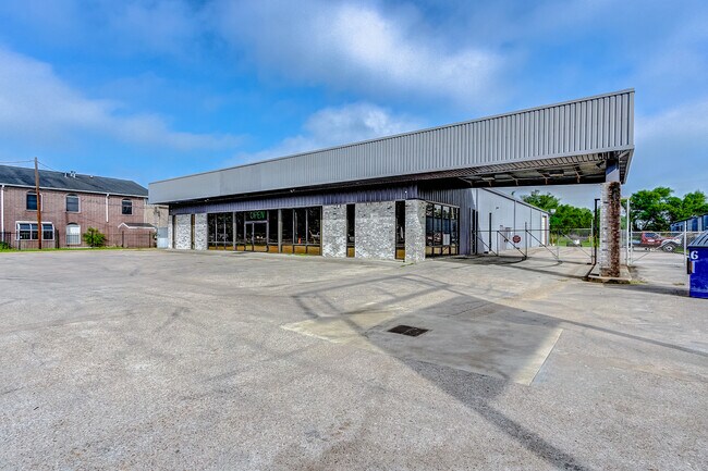
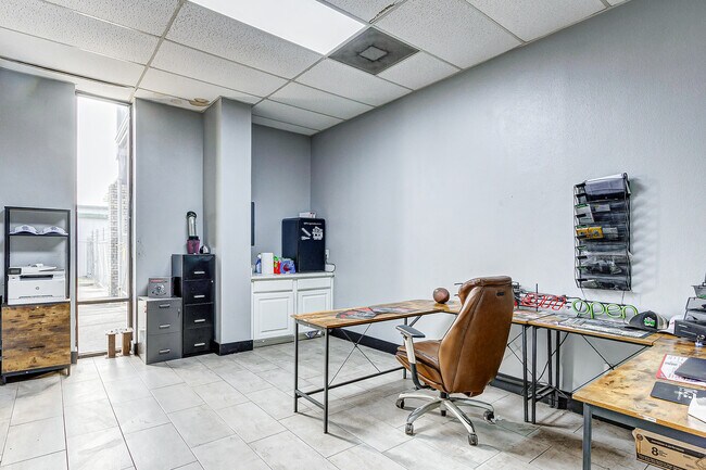
Property Record
3501 Fm 1960 Rd E, Humble, TX 77338

Property Detail
3501 Fm 1960 Rd E
0420800000053
TR 2A-2 ABST 223 R DUNMAN
Autorepair
HARRIS
B and X Area of moderate flood hazard, usually the area between the limits of the 100-year and 500-year floods.
Texas
2024
1.45 AC
2025
Northeast Hwy 90
250701
Houston
12,000 SF
Houston-Pasadena-The Woodlands, TX
NEARBY LISTINGS FOR SALE OR LEASE
DEMOGRAPHICS near 3501 Fm 1960 Rd E
1 mile
3 mile
5 mile
2025 Total Population
547
65,401
204,425
2030 Population
587
69,304
220,149
Pop Growth 2025-2030
+ 7.31%
+ 5.97%
+ 7.69%
Average Age
38
36
37
2025 Total Households
200
21,532
70,655
HH Growth 2025-2030
+ 7.50%
+ 6.15%
+ 8.09%
Median Household Inc
$75,926
$96,124
$95,852
Avg Household Size
2.80
3.00
2.90
2025 Avg HH Vehicles
2.00
2.00
2.00
Median Home Value
$361,666
$278,650
$304,109
Median Year Built
1992
1999
2002
Nearby Places
Map Layers
Map Styles
 Street
 Aerial
Transit
 Traffic
 Biking
Places
Listings with unknown addresses are not visible on the map
- Restaurants
- Banks
- Shops
- Fitness
- Groceries
PUBLIC TRANSPORTATION
AIRPORT
George Bush Intcntl/Houston
Drive
Walk
Distance
George Bush Intcntl/Houston
17 min
11.5 mi
William P Hobby
Drive
Walk
Distance
William P Hobby
49 min
33.1 mi
Freight Ports
Port of Houston
Drive
Walk
Distance
Port of Houston
38 min
26.8 mi
SALE & LEASE HISTORY
LISTING DATE
SALE/LEASE

Sep 23, 2016
For Sale
Oct 17, 2016
For Sale
Nov 20, 2024
For Sale
May 24, 2023
For Sale
Jun 14, 2017
For Sale
Dec 11, 2023
For Lease
Dec 07, 2021
For Sale
Apr 12, 2018
For Sale
Nearby Properties
Address
Land Use
TOTAL SIZE
Lot Size
Zoning
Address
Land Use
TOTAL SIZE
Lot Size
Zoning
356,311 SF
15.60 AC
Address
Land Use
TOTAL SIZE
Lot Size
Zoning
326,166 SF
11.84 AC
Address
Land Use
TOTAL SIZE
Lot Size
Zoning
320,200 SF
19.56 AC
Address
Land Use
TOTAL SIZE
Lot Size
Zoning
212,020 SF
Address
Land Use
TOTAL SIZE
Lot Size
Zoning
268,939 SF
11.24 AC
Address
Land Use
TOTAL SIZE
Lot Size
Zoning
304,671 SF
14.77 AC
Address
Land Use
TOTAL SIZE
Lot Size
Zoning
80,722 SF
28.27 AC
Address
Land Use
TOTAL SIZE
Lot Size
Zoning
274,992 SF
11.55 AC
Address
Land Use
TOTAL SIZE
Lot Size
Zoning
174,820 SF
13.30 AC
Address
Land Use
TOTAL SIZE
Lot Size
Zoning
208,856 SF
23.08 AC
Address
Land Use
TOTAL SIZE
Lot Size
Zoning
128,886 SF
6.36 AC
Address
Land Use
TOTAL SIZE
Lot Size
Zoning
192,620 SF
7.46 AC
Address
Land Use
TOTAL SIZE
Lot Size
Zoning
4,168 SF
20.04 AC
Address
Land Use
TOTAL SIZE
Lot Size
Zoning
160,575 SF
3.62 AC
Address
Land Use
TOTAL SIZE
Lot Size
Zoning
213,292 SF
9.81 AC
Address
Land Use
TOTAL SIZE
Lot Size
Zoning
122,944 SF
10.72 AC
Address
Land Use
TOTAL SIZE
Lot Size
Zoning
176,838 SF
13.67 AC
Address
Land Use
TOTAL SIZE
Lot Size
Zoning
63,600 SF
5.99 AC
Address
Land Use
TOTAL SIZE
Lot Size
Zoning
117,795 SF
5.45 AC
Address
Land Use
TOTAL SIZE
Lot Size
Zoning
161,641 SF
6.74 AC
Address
Land Use
TOTAL SIZE
Lot Size
Zoning
47,988 SF
1.86 AC
Address
Land Use
TOTAL SIZE
Lot Size
Zoning
91,090 SF
4.72 AC
Address
Land Use
TOTAL SIZE
Lot Size
Zoning
116,328 SF
7.61 AC
Address
Land Use
TOTAL SIZE
Lot Size
Zoning
77,952 SF
6.50 AC
Address
Land Use
TOTAL SIZE
Lot Size
Zoning
197,292 SF
13.77 AC
Address
Land Use
TOTAL SIZE
Lot Size
Zoning
143,220 SF
6.50 AC
Address
Land Use
TOTAL SIZE
Lot Size
Zoning
141,550 SF
5.86 AC
Address
Land Use
TOTAL SIZE
Lot Size
Zoning
139,808 SF
13.50 AC
Address
Land Use
TOTAL SIZE
Lot Size
Zoning
83,588 SF
3.24 AC
Address
Land Use
TOTAL SIZE
Lot Size
Zoning
47,960 SF
25 AC
The World's #1 Commercial Real Estate Marketplace
Connect with us
© 2026 CoStar Group
The information above has been obtained from sources believed reliable. While we do not doubt its accuracy we have not verified it and make no guarantee, warranty or representation about it. It is your responsibility to independently confirm its accuracy and completeness. Any projections, opinions, assumptions, or estimates used are for example only and do not represent the current or future performance of the property. The value of this transaction to you depends on tax and other factors which should be evaluated by your tax, financial, and legal advisors. You and your advisors should conduct a careful, independent investigation of the property to determine to your satisfaction the suitability of the property for your needs.