Property Record
3501 Nafta Pky, Brownsville, TX 78526

NEARBY LISTINGS FOR SALE OR LEASE
Property Detail
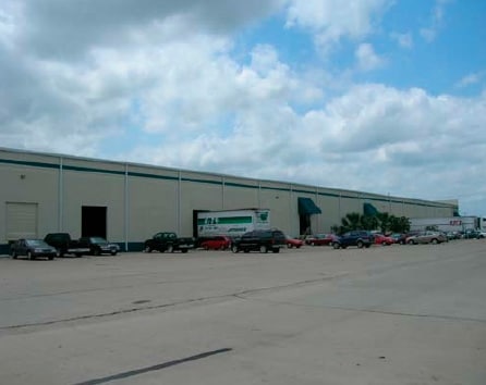
3501 Nafta Pky
Brownsville-Harlingen, TX
El Jardin Resubdivision
747540-2140-004402
EL JARDIN RESUBDIVISION 11.335 ACRES OUT OF 30.04 AC OF LOT 4 BLK 214
Commercialnec
Cameron
A
Texas
48061C0585F
4
2024
11.34 AC
2025
Greater Brownsville
012607
Brownsville/Harlingen
100,000 SF
DEMOGRAPHICS near 3501 Nafta Pky
1 Mile
3 Mile
5 Mile
2024 Total Population
5,934
38,610
116,282
2029 Population
6,034
39,897
119,299
Pop Growth 2024-2029
+ 1.69%
+ 3.33%
+ 2.59%
Average Age
33
34
35
2024 Total Households
1,563
11,386
35,286
HH Growth 2024-2029
+ 1.66%
+ 3.41%
+ 2.65%
Median Household Inc
$58,842
$43,672
$42,965
Avg Household Size
3.70
3.30
3.20
2024 Avg HH Vehicles
2.00
2.00
2.00
Median Home Value
$83,948
$85,619
$93,875
Median Year Built
1996
1997
1994
Nearby Places
Map Layers
Map Styles
 Street
 Aerial
- Restaurants
- Banks
- Shops
- Fitness
- Groceries
PUBLIC TRANSPORTATION
AIRPORT
Brownsville/South Padre Island International
DRIVE
WALK
Distance
Brownsville/South Padre Island International
9 min
4.5 mi
Valley International
DRIVE
WALK
Distance
Valley International
43 min
28.2 mi
Freight Ports
Port of Brownsville
DRIVE
WALK
Distance
Port of Brownsville
1 min
0.7 mi
Nearby Properties
Address
Land Use
TOTAL SIZE
Lot Size
Zoning
Address
Land Use
TOTAL SIZE
Lot Size
Zoning
167,737 SF
29.87 AC
Address
Land Use
TOTAL SIZE
Lot Size
Zoning
286,243 SF
19.21 AC
C
Address
Land Use
TOTAL SIZE
Lot Size
Zoning
145,240 SF
17.49 AC
Address
Land Use
TOTAL SIZE
Lot Size
Zoning
4.56 AC
C
Address
Land Use
TOTAL SIZE
Lot Size
Zoning
115,463 SF
22.09 AC
Address
Land Use
TOTAL SIZE
Lot Size
Zoning
120,166 SF
12.33 AC
Address
Land Use
TOTAL SIZE
Lot Size
Zoning
87,909 SF
12 AC
Address
Land Use
TOTAL SIZE
Lot Size
Zoning
112,263 SF
9.66 AC
Address
Land Use
TOTAL SIZE
Lot Size
Zoning
98,740 SF
15.56 AC
Address
Land Use
TOTAL SIZE
Lot Size
Zoning
81,191 SF
19.56 AC
Address
Land Use
TOTAL SIZE
Lot Size
Zoning
238,221 SF
27.02 AC
Address
Land Use
TOTAL SIZE
Lot Size
Zoning
88,256 SF
18.16 AC
Address
Land Use
TOTAL SIZE
Lot Size
Zoning
299,792 SF
12.88 AC
C
Address
Land Use
TOTAL SIZE
Lot Size
Zoning
137,228 SF
18.43 AC
A-U
Address
Land Use
TOTAL SIZE
Lot Size
Zoning
96,824 SF
7.83 AC
Address
Land Use
TOTAL SIZE
Lot Size
Zoning
0.17 AC
Address
Land Use
TOTAL SIZE
Lot Size
Zoning
102,440 SF
22.88 AC
Address
Land Use
TOTAL SIZE
Lot Size
Zoning
48,760 SF
7 AC
C
Address
Land Use
TOTAL SIZE
Lot Size
Zoning
13,665 SF
93.80 AC
Address
Land Use
TOTAL SIZE
Lot Size
Zoning
128,200 SF
9.92 AC
Address
Land Use
TOTAL SIZE
Lot Size
Zoning
82,300 SF
3.20 AC
I
Address
Land Use
TOTAL SIZE
Lot Size
Zoning
145,339 SF
10 AC
C
Address
Land Use
TOTAL SIZE
Lot Size
Zoning
102,432 SF
5.27 AC
C
Address
Land Use
TOTAL SIZE
Lot Size
Zoning
100,000 SF
7.93 AC
I
Address
Land Use
TOTAL SIZE
Lot Size
Zoning
100,000 SF
7.79 AC
I
Address
Land Use
TOTAL SIZE
Lot Size
Zoning
100,000 SF
5.20 AC
I
Address
Land Use
TOTAL SIZE
Lot Size
Zoning
104,000 SF
15.12 AC
I
Address
Land Use
TOTAL SIZE
Lot Size
Zoning
101,581 SF
4.14 AC
Address
Land Use
TOTAL SIZE
Lot Size
Zoning
101,674 SF
8.14 AC
C
Address
Land Use
TOTAL SIZE
Lot Size
Zoning
9,413 SF
31.65 AC
AC
The World's #1 Commercial Real Estate Marketplace
Connect with us
© 2026 CoStar Group
The information above has been obtained from sources believed reliable. While we do not doubt its accuracy we have not verified it and make no guarantee, warranty or representation about it. It is your responsibility to independently confirm its accuracy and completeness. Any projections, opinions, assumptions, or estimates used are for example only and do not represent the current or future performance of the property. The value of this transaction to you depends on tax and other factors which should be evaluated by your tax, financial, and legal advisors. You and your advisors should conduct a careful, independent investigation of the property to determine to your satisfaction the suitability of the property for your needs.