Property Record
3501 W Rolling Hills Cir, Davie, FL 33328


NEARBY LISTINGS FOR SALE OR LEASE
Property Detail
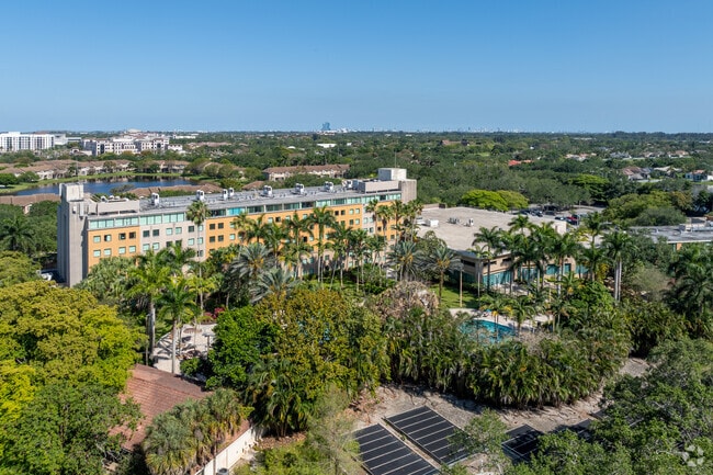
3501 W Rolling Hills Cir
50-41-21-07-0011
Rolling Hills Golf & Tennis Club
University
ROLLING HILLS GOLF & TENNIS CLUB 81-27 B,A POR OF PAR A DESC AS COMM AT INTERSECT OF E R/W/L OF PINE IS RD WITH N R/W/L OF SW 35 ST,E 2075.61 TO POB,N 700.30,NE 165.47,E 321.47,SE 50,S 527.45 AN ARC DIST 174.83,TO P/R/C AN ARC DIST 20.29,TO P/C/C AN
X
Broward
12011C0535J
Florida
2024
9.01 AC
2025
Rolling Hills Golf & Tennis Club
070211
South Florida
209,319 SF
Fort Lauderdale-Pompano Beach-Sunrise, FL
DEMOGRAPHICS near 3501 W Rolling Hills Cir
1 Mile
3 Mile
5 Mile
2024 Total Population
10,647
95,493
310,002
2029 Population
10,458
94,595
305,447
Pop Growth 2024-2029
(1.78%)
(0.94%)
(1.47%)
Average Age
38
39
40
2024 Total Households
3,935
35,731
111,839
HH Growth 2024-2029
(2.62%)
(1.40%)
(1.94%)
Median Household Inc
$93,576
$81,015
$76,876
Avg Household Size
2.40
2.60
2.60
2024 Avg HH Vehicles
2.00
2.00
2.00
Median Home Value
$436,137
$417,463
$365,442
Median Year Built
1986
1984
1980
Nearby Places
Map Layers
Map Styles
 Street
 Aerial
- Restaurants
- Banks
- Shops
- Fitness
- Groceries
PUBLIC TRANSPORTATION
COMMUTER RAIL
Fort Lauderdale/Hollywood International Airport (Mangonia Park - Miami Airport - Tri-Rail, Tri-County Commuter - Tri-Rail, West Palm Beach - MiamiCentral - Tri-Rail)
DRIVE
WALK
Distance
Fort Lauderdale/Hollywood International Airport (Mangonia Park - Miami Airport - Tri-Rail, Tri-County Commuter - Tri-Rail, West Palm Beach - MiamiCentral - Tri-Rail)
14 min
7.0 mi
Fort Lauderdale (Tri-County Commuter - South Florida Regional Transportation Authority (Tri-Rail))
DRIVE
WALK
Distance
Fort Lauderdale (Tri-County Commuter - South Florida Regional Transportation Authority (Tri-Rail))
19 min
8.9 mi
AIRPORT
Fort Lauderdale/Hollywood International
DRIVE
WALK
Distance
Fort Lauderdale/Hollywood International
16 min
7.9 mi
Miami International
DRIVE
WALK
Distance
Miami International
45 min
29.0 mi
Freight Ports
Port Everglades
DRIVE
WALK
Distance
Port Everglades
17 min
11.1 mi
Nearby Properties
Address
Land Use
TOTAL SIZE
Lot Size
Zoning
Address
Land Use
TOTAL SIZE
Lot Size
Zoning
4,069,966 SF
161.58 AC
RAC-AV
Address
Land Use
TOTAL SIZE
Lot Size
Zoning
589,748 SF
27.34 AC
RAC-RTE
Address
Land Use
TOTAL SIZE
Lot Size
Zoning
663,255 SF
3.15 AC
RAC-CC
Address
Land Use
TOTAL SIZE
Lot Size
Zoning
1,357,572 SF
126.23 AC
RAC-ED
Address
Land Use
TOTAL SIZE
Lot Size
Zoning
550,907 SF
26.92 AC
RAC-RTE
Address
Land Use
TOTAL SIZE
Lot Size
Zoning
627,368 SF
4.33 AC
PRD-21Q
Address
Land Use
TOTAL SIZE
Lot Size
Zoning
475,897 SF
14.91 AC
RAC-RTE
Address
Land Use
TOTAL SIZE
Lot Size
Zoning
413,123 SF
63.50 AC
B-3
Address
Land Use
TOTAL SIZE
Lot Size
Zoning
438,123 SF
47.44 AC
RM-22
Address
Land Use
TOTAL SIZE
Lot Size
Zoning
409,340 SF
15.49 AC
RAC-RTE
Address
Land Use
TOTAL SIZE
Lot Size
Zoning
613,363 SF
6.24 AC
B-7Q
Address
Land Use
TOTAL SIZE
Lot Size
Zoning
517,961 SF
3.92 AC
M-PM
Address
Land Use
TOTAL SIZE
Lot Size
Zoning
635,706 SF
9.58 AC
GRIFFIN CO
Address
Land Use
TOTAL SIZE
Lot Size
Zoning
456,384 SF
81.33 AC
RAC-ED
Address
Land Use
TOTAL SIZE
Lot Size
Zoning
471,109 SF
5.57 AC
M-PM
Address
Land Use
TOTAL SIZE
Lot Size
Zoning
576,167 SF
27 AC
RAC-RTE
Address
Land Use
TOTAL SIZE
Lot Size
Zoning
527,086 SF
2.34 AC
M-PM
Address
Land Use
TOTAL SIZE
Lot Size
Zoning
334,723 SF
7.47 AC
RAC-AV
Address
Land Use
TOTAL SIZE
Lot Size
Zoning
350,663 SF
16.86 AC
RAC-RTE
Address
Land Use
TOTAL SIZE
Lot Size
Zoning
356,053 SF
8.12 AC
RAC-RTE
Address
Land Use
TOTAL SIZE
Lot Size
Zoning
320,919 SF
27.70 AC
M-PM
Address
Land Use
TOTAL SIZE
Lot Size
Zoning
439,908 SF
13.54 AC
OP-P
Address
Land Use
TOTAL SIZE
Lot Size
Zoning
505,730 SF
18.07 AC
RAC-AV
Address
Land Use
TOTAL SIZE
Lot Size
Zoning
292,581 SF
13.64 AC
RM-16
Address
Land Use
TOTAL SIZE
Lot Size
Zoning
312,067 SF
20.94 AC
PRD-15Q
Address
Land Use
TOTAL SIZE
Lot Size
Zoning
222,024 SF
13.64 AC
RM-16
Address
Land Use
TOTAL SIZE
Lot Size
Zoning
445,798 SF
11.80 AC
OP-P
Address
Land Use
TOTAL SIZE
Lot Size
Zoning
302,410 SF
35.11 AC
X-1
Address
Land Use
TOTAL SIZE
Lot Size
Zoning
337,994 SF
3.03 AC
RAC-ND4
Address
Land Use
TOTAL SIZE
Lot Size
Zoning
242,841 SF
17.21 AC
M-PM
The World's #1 Commercial Real Estate Marketplace
Connect with us
© 2026 CoStar Group
The information above has been obtained from sources believed reliable. While we do not doubt its accuracy we have not verified it and make no guarantee, warranty or representation about it. It is your responsibility to independently confirm its accuracy and completeness. Any projections, opinions, assumptions, or estimates used are for example only and do not represent the current or future performance of the property. The value of this transaction to you depends on tax and other factors which should be evaluated by your tax, financial, and legal advisors. You and your advisors should conduct a careful, independent investigation of the property to determine to your satisfaction the suitability of the property for your needs.