Property Record
3502 N Bendix Dr, South Bend, IN 46628

Save to a Folder
{{folder.Name}}
{{folder.ListingIds.length}} Properties
{{folder.ListingIds.length}} Property
Create a New Folder
Property Detail
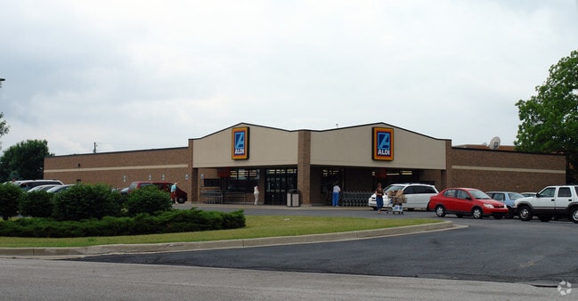
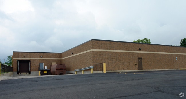
3502 N Bendix Dr
South Bend-Mishawaka, IN-MI
GMS REALTYS PORTAGE ROAD SECOND MINOR SUB LOT 5
71-03-22-377-002.000-009
St Joseph
Supermarket
Indiana
B and X Area of moderate flood hazard, usually the area between the limits of the 100-year and 500-year floods.
5
2024
3.17 AC
2025
Greater South Bend
011002
South Bend/Mishawaka
19,500 SF
NEARBY LISTINGS FOR SALE OR LEASE
DEMOGRAPHICS near 3502 N Bendix Dr
1 mile
3 mile
5 mile
2025 Total Population
4,494
42,086
120,284
2030 Population
4,410
43,438
123,046
Pop Growth 2025-2030
(1.87%)
+ 3.21%
+ 2.30%
Average Age
40
38
38
2025 Total Households
2,117
16,752
45,494
HH Growth 2025-2030
(2.08%)
+ 3.88%
+ 2.66%
Median Household Inc
$54,246
$62,115
$62,204
Avg Household Size
2.10
2.30
2.30
2025 Avg HH Vehicles
1.00
2.00
2.00
Median Home Value
$220,350
$171,071
$180,290
Median Year Built
1979
1970
1965
Nearby Places
Map Layers
Map Styles
 Street
 Aerial
Layers
 Traffic
 Biking
Places
Listings with unknown addresses are not visible on the map
- Restaurants
- Banks
- Shops
- Fitness
- Groceries
PUBLIC TRANSPORTATION
COMMUTER RAIL
South Bend Airport Station (South Shore Line - Northern Indiana Commuter Transportation District (South Shore Line))
Drive
Walk
Distance
South Bend Airport Station (South Shore Line - Northern Indiana Commuter Transportation District (South Shore Line))
9 min
3.0 mi
Drive
Walk
Distance
9 min
3.8 mi
AIRPORT
South Bend International
Drive
Walk
Distance
South Bend International
19 min
6.0 mi
Nearby Properties
Address
Land Use
TOTAL SIZE
Lot Size
Zoning
Address
Land Use
TOTAL SIZE
Lot Size
Zoning
1,089,534 SF
436.76 AC
Address
Land Use
TOTAL SIZE
Lot Size
Zoning
102,124 SF
75.34 AC
Address
Land Use
TOTAL SIZE
Lot Size
Zoning
57,170 SF
0.84 AC
Address
Land Use
TOTAL SIZE
Lot Size
Zoning
38,938 SF
114.29 AC
Address
Land Use
TOTAL SIZE
Lot Size
Zoning
210,420 SF
24.58 AC
Address
Land Use
TOTAL SIZE
Lot Size
Zoning
292,085 SF
30.05 AC
Address
Land Use
TOTAL SIZE
Lot Size
Zoning
7,138 SF
28.07 AC
Address
Land Use
TOTAL SIZE
Lot Size
Zoning
13,328 SF
96.72 AC
Address
Land Use
TOTAL SIZE
Lot Size
Zoning
37,285 SF
5.92 AC
Address
Land Use
TOTAL SIZE
Lot Size
Zoning
296,370 SF
30.40 AC
Address
Land Use
TOTAL SIZE
Lot Size
Zoning
42,592 SF
0.70 AC
Address
Land Use
TOTAL SIZE
Lot Size
Zoning
51,298 SF
13.48 AC
Address
Land Use
TOTAL SIZE
Lot Size
Zoning
232,200 SF
21.27 AC
Address
Land Use
TOTAL SIZE
Lot Size
Zoning
34,544 SF
6.82 AC
Address
Land Use
TOTAL SIZE
Lot Size
Zoning
9,080 SF
19.59 AC
Address
Land Use
TOTAL SIZE
Lot Size
Zoning
43,946 SF
4.17 AC
Address
Land Use
TOTAL SIZE
Lot Size
Zoning
212,497 SF
31.80 AC
Address
Land Use
TOTAL SIZE
Lot Size
Zoning
210,420 SF
30.25 AC
Address
Land Use
TOTAL SIZE
Lot Size
Zoning
49,017 SF
7.45 AC
Address
Land Use
TOTAL SIZE
Lot Size
Zoning
63,780 SF
6.32 AC
Address
Land Use
TOTAL SIZE
Lot Size
Zoning
20,306 SF
9.43 AC
Address
Land Use
TOTAL SIZE
Lot Size
Zoning
203,750 SF
22.36 AC
Address
Land Use
TOTAL SIZE
Lot Size
Zoning
72,418 SF
31.51 AC
Address
Land Use
TOTAL SIZE
Lot Size
Zoning
1,664 SF
26.65 AC
Address
Land Use
TOTAL SIZE
Lot Size
Zoning
165,000 SF
15.88 AC
Address
Land Use
TOTAL SIZE
Lot Size
Zoning
88,808 SF
1.19 AC
Address
Land Use
TOTAL SIZE
Lot Size
Zoning
38,321 SF
22.26 AC
Address
Land Use
TOTAL SIZE
Lot Size
Zoning
85,000 SF
23.71 AC
Address
Land Use
TOTAL SIZE
Lot Size
Zoning
4,705 SF
1.99 AC
Address
Land Use
TOTAL SIZE
Lot Size
Zoning
79,451 SF
20.07 AC
The World's #1 Commercial Real Estate Marketplace
Connect with us
© 2026 CoStar Group
The information above has been obtained from sources believed reliable. While we do not doubt its accuracy we have not verified it and make no guarantee, warranty or representation about it. It is your responsibility to independently confirm its accuracy and completeness. Any projections, opinions, assumptions, or estimates used are for example only and do not represent the current or future performance of the property. The value of this transaction to you depends on tax and other factors which should be evaluated by your tax, financial, and legal advisors. You and your advisors should conduct a careful, independent investigation of the property to determine to your satisfaction the suitability of the property for your needs.