Property Record
3502 W 450 N, Thorntown, IN 46071
This Property Is For Sale
NEARBY LISTINGS FOR SALE OR LEASE
Property Detail
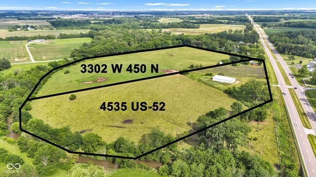
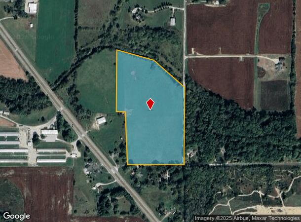
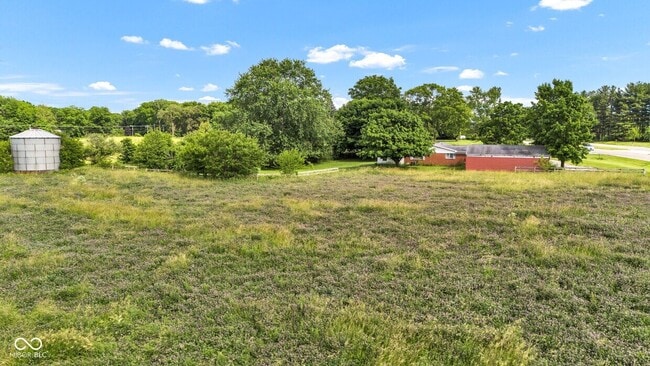
3502 W 450 N
06-10-09-000-015.001-017
PT E1/2 NW 9-19-1W 21.66A PER SURVEY
Agriculturalland
Boone
A
Indiana
18011C0160E
21.66 AC
2024
Boone County
2025
Indianapolis
810100
Indianapolis-Carmel-Anderson, IN
DEMOGRAPHICS near 3502 W 450 N
1 Mile
3 Mile
5 Mile
2024 Total Population
132
1,051
15,061
2029 Population
143
1,135
16,368
Pop Growth 2024-2029
+ 8.33%
+ 7.99%
+ 8.68%
Average Age
43
43
42
2024 Total Households
51
411
6,186
HH Growth 2024-2029
+ 7.84%
+ 8.27%
+ 8.97%
Median Household Inc
$47,999
$51,333
$68,235
Avg Household Size
2.60
2.50
2.40
2024 Avg HH Vehicles
2.00
2.00
2.00
Median Home Value
$294,999
$289,999
$237,255
Median Year Built
1966
1971
1985
Nearby Places
Map Layers
Map Styles
 Street
 Aerial
- Restaurants
- Banks
- Shops
- Fitness
- Groceries
PUBLIC TRANSPORTATION
AIRPORT
Indianapolis International
DRIVE
WALK
Distance
Indianapolis International
55 min
38.2 mi
Freight Ports
Port of Toledo
DRIVE
WALK
Distance
Port of Toledo
292 min
246.8 mi
Nearby Properties
Address
Land Use
TOTAL SIZE
Lot Size
Zoning
Address
Land Use
TOTAL SIZE
Lot Size
Zoning
165.63 AC
ZO01
Address
Land Use
TOTAL SIZE
Lot Size
Zoning
78.33 AC
ZO01
Address
Land Use
TOTAL SIZE
Lot Size
Zoning
19.78 AC
ZO01
Address
Land Use
TOTAL SIZE
Lot Size
Zoning
5,040 SF
19.43 AC
ZO01
Address
Land Use
TOTAL SIZE
Lot Size
Zoning
4,924 SF
11.36 AC
ZO01
Address
Land Use
TOTAL SIZE
Lot Size
Zoning
2,880 SF
27.49 AC
ZO01
Address
Land Use
TOTAL SIZE
Lot Size
Zoning
8,100 SF
52.76 AC
ZO01
Address
Land Use
TOTAL SIZE
Lot Size
Zoning
2,016 SF
12.40 AC
ZO01
Address
Land Use
TOTAL SIZE
Lot Size
Zoning
88.51 AC
ZO01
Address
Land Use
TOTAL SIZE
Lot Size
Zoning
22,048 SF
80 AC
ZO01
Address
Land Use
TOTAL SIZE
Lot Size
Zoning
101.03 AC
ZO01
Address
Land Use
TOTAL SIZE
Lot Size
Zoning
224 AC
ZO01
Address
Land Use
TOTAL SIZE
Lot Size
Zoning
79 AC
ZO01
Address
Land Use
TOTAL SIZE
Lot Size
Zoning
79.87 AC
ZO01
Address
Land Use
TOTAL SIZE
Lot Size
Zoning
38.80 AC
ZO01
Address
Land Use
TOTAL SIZE
Lot Size
Zoning
117.26 AC
ZO01
Address
Land Use
TOTAL SIZE
Lot Size
Zoning
165.33 AC
ZO01
Address
Land Use
TOTAL SIZE
Lot Size
Zoning
1.03 AC
ZO01
Address
Land Use
TOTAL SIZE
Lot Size
Zoning
147.81 AC
ZO01
Address
Land Use
TOTAL SIZE
Lot Size
Zoning
134.67 AC
ZO01
Address
Land Use
TOTAL SIZE
Lot Size
Zoning
134.04 AC
ZO01
Address
Land Use
TOTAL SIZE
Lot Size
Zoning
129.62 AC
ZO01
Address
Land Use
TOTAL SIZE
Lot Size
Zoning
143.80 AC
ZO01
Address
Land Use
TOTAL SIZE
Lot Size
Zoning
59.95 AC
ZO01
Address
Land Use
TOTAL SIZE
Lot Size
Zoning
126.27 AC
ZO01
Address
Land Use
TOTAL SIZE
Lot Size
Zoning
26.52 AC
ZO01
Address
Land Use
TOTAL SIZE
Lot Size
Zoning
123.37 AC
ZO01
Address
Land Use
TOTAL SIZE
Lot Size
Zoning
115.98 AC
ZO01
Address
Land Use
TOTAL SIZE
Lot Size
Zoning
114.21 AC
ZO01
Address
Land Use
TOTAL SIZE
Lot Size
Zoning
5.47 AC
ZO01
The World's #1 Commercial Real Estate Marketplace
Connect with us
© 2025 CoStar Group
The information above has been obtained from sources believed reliable. While we do not doubt its accuracy we have not verified it and make no guarantee, warranty or representation about it. It is your responsibility to independently confirm its accuracy and completeness. Any projections, opinions, assumptions, or estimates used are for example only and do not represent the current or future performance of the property. The value of this transaction to you depends on tax and other factors which should be evaluated by your tax, financial, and legal advisors. You and your advisors should conduct a careful, independent investigation of the property to determine to your satisfaction the suitability of the property for your needs.