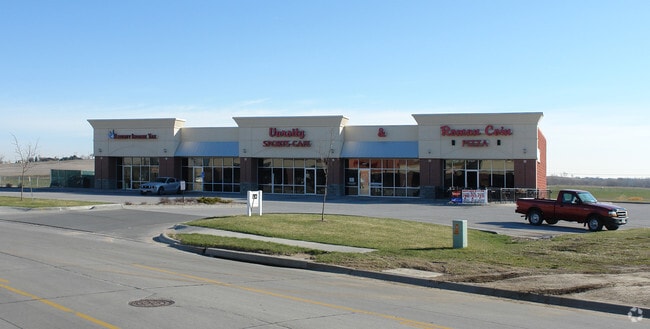
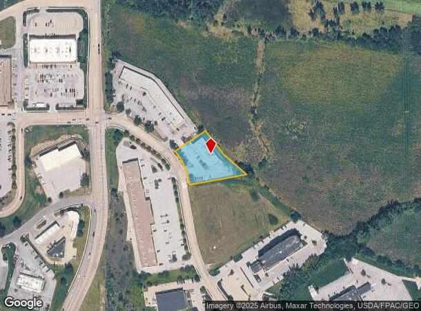
Property Record
3504 Samson Way, Bellevue, NE 68123

NEARBY LISTINGS FOR SALE OR LEASE
-
-
View all Bellevue listings for lease on LoopNet.com
Property Detail
3504 Samson Way
Omaha-Council Bluffs, NE-IA
Daniell Crossing
011576072
LOT 2 DANIELL CROSSING REPLAT 3 (.83 AC)
Commercialnec
Sarpy
AE
Nebraska
31153C0090H
2
2024
0.83 AC
2025
Sarpy East
010204
Omaha/Council Bluffs
6,250 SF
DEMOGRAPHICS near 3504 Samson Way
1 Mile
3 Mile
5 Mile
2024 Total Population
7,649
59,721
146,776
2029 Population
8,295
64,540
156,325
Pop Growth 2024-2029
+ 8.45%
+ 8.07%
+ 6.51%
Average Age
36
37
37
2024 Total Households
3,087
22,071
53,389
HH Growth 2024-2029
+ 8.62%
+ 8.19%
+ 6.81%
Median Household Inc
$70,499
$81,751
$73,692
Avg Household Size
2.40
2.60
2.70
2024 Avg HH Vehicles
2.00
2.00
2.00
Median Home Value
$267,659
$252,623
$222,719
Median Year Built
1995
1993
1983
Nearby Places
Map Layers
Map Styles
 Street
 Aerial
- Restaurants
- Banks
- Shops
- Fitness
- Groceries
PUBLIC TRANSPORTATION
AIRPORT
Eppley Airfield
DRIVE
WALK
Distance
Eppley Airfield
26 min
15.6 mi
SALE & LEASE HISTORY
LISTING DATE
SALE/LEASE

Oct 04, 2022
For Lease
Nearby Properties
Address
Land Use
TOTAL SIZE
Lot Size
Zoning
Address
Land Use
TOTAL SIZE
Lot Size
Zoning
272,760 SF
2.40 AC
Address
Land Use
TOTAL SIZE
Lot Size
Zoning
276,509 SF
3.67 AC
Address
Land Use
TOTAL SIZE
Lot Size
Zoning
17,155 SF
13.11 AC
Address
Land Use
TOTAL SIZE
Lot Size
Zoning
24,969 SF
3.79 AC
RG20
Address
Land Use
TOTAL SIZE
Lot Size
Zoning
10,052 SF
9.38 AC
Address
Land Use
TOTAL SIZE
Lot Size
Zoning
3,906 SF
13.62 AC
RG20
Address
Land Use
TOTAL SIZE
Lot Size
Zoning
160,000 SF
22.48 AC
Address
Land Use
TOTAL SIZE
Lot Size
Zoning
18,727 SF
11.15 AC
RG20
Address
Land Use
TOTAL SIZE
Lot Size
Zoning
143 SF
17.56 AC
RG28
Address
Land Use
TOTAL SIZE
Lot Size
Zoning
10,800 SF
12.03 AC
Address
Land Use
TOTAL SIZE
Lot Size
Zoning
88,545 SF
9.58 AC
Address
Land Use
TOTAL SIZE
Lot Size
Zoning
1,216 SF
22.82 AC
Address
Land Use
TOTAL SIZE
Lot Size
Zoning
37,196 SF
13.96 AC
MU
Address
Land Use
TOTAL SIZE
Lot Size
Zoning
117,829 SF
11.13 AC
BG
Address
Land Use
TOTAL SIZE
Lot Size
Zoning
119,396 SF
13.46 AC
Address
Land Use
TOTAL SIZE
Lot Size
Zoning
226,320 SF
12.75 AC
Address
Land Use
TOTAL SIZE
Lot Size
Zoning
3.95 AC
Address
Land Use
TOTAL SIZE
Lot Size
Zoning
400 SF
23.26 AC
Address
Land Use
TOTAL SIZE
Lot Size
Zoning
42,900 SF
16.25 AC
Address
Land Use
TOTAL SIZE
Lot Size
Zoning
2,032 SF
8.67 AC
Address
Land Use
TOTAL SIZE
Lot Size
Zoning
62,735 SF
0.65 AC
Address
Land Use
TOTAL SIZE
Lot Size
Zoning
212,990 SF
8.75 AC
MH
Address
Land Use
TOTAL SIZE
Lot Size
Zoning
88,232 SF
6.72 AC
BG
Address
Land Use
TOTAL SIZE
Lot Size
Zoning
1,103 SF
9.27 AC
Address
Land Use
TOTAL SIZE
Lot Size
Zoning
33,713 SF
14.39 AC
Address
Land Use
TOTAL SIZE
Lot Size
Zoning
63,669 SF
6.58 AC
Address
Land Use
TOTAL SIZE
Lot Size
Zoning
6,140 SF
7.05 AC
Address
Land Use
TOTAL SIZE
Lot Size
Zoning
29,867 SF
3.69 AC
Address
Land Use
TOTAL SIZE
Lot Size
Zoning
18,752 SF
7.06 AC
The World's #1 Commercial Real Estate Marketplace
Connect with us
© 2025 CoStar Group
The information above has been obtained from sources believed reliable. While we do not doubt its accuracy we have not verified it and make no guarantee, warranty or representation about it. It is your responsibility to independently confirm its accuracy and completeness. Any projections, opinions, assumptions, or estimates used are for example only and do not represent the current or future performance of the property. The value of this transaction to you depends on tax and other factors which should be evaluated by your tax, financial, and legal advisors. You and your advisors should conduct a careful, independent investigation of the property to determine to your satisfaction the suitability of the property for your needs.