Property Record
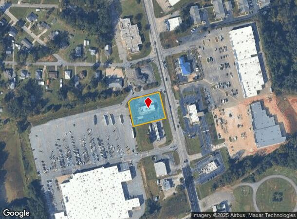
3505 20Th Ave, Valley, AL 36854

NEARBY LISTINGS FOR SALE OR LEASE
Property Detail
3505 20Th Ave
18-03-06-3-000-046.002
START AT INT OF SE MARGIN OF 35TH STREET & SW MARGIN OF 20TH AVENUE, RUN SE'LY ALONG AVENUE 207' TO P.O.B., RUN SE'LY ALONG A
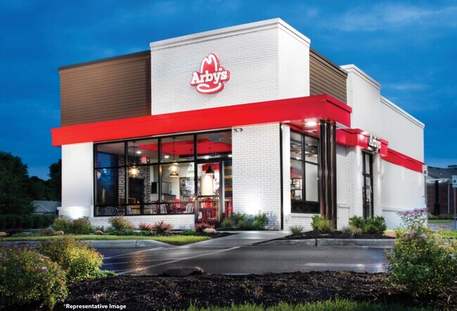
Restaurantdrivein
Chambers
X
Alabama
13285C0310F
0.90 AC
2025
Chambers County
2024
Columbus GA
954600
LaGrange, GA-AL
3,063 SF
DEMOGRAPHICS near 3505 20Th Ave
1 Mile
3 Mile
5 Mile
2024 Total Population
2,689
17,523
25,516
2029 Population
2,602
17,483
25,334
Pop Growth 2024-2029
(3.24%)
(0.23%)
(0.71%)
Average Age
41
41
41
2024 Total Households
1,094
7,116
10,298
HH Growth 2024-2029
(3.11%)
(0.15%)
(0.61%)
Median Household Inc
$40,227
$47,193
$48,323
Avg Household Size
2.40
2.40
2.40
2024 Avg HH Vehicles
2.00
2.00
2.00
Median Home Value
$126,933
$123,944
$122,407
Median Year Built
1961
1974
1974
Nearby Places
Map Layers
Map Styles
 Street
 Aerial
- Restaurants
- Banks
- Shops
- Fitness
- Groceries
PUBLIC TRANSPORTATION
AIRPORT
Columbus
DRIVE
WALK
Distance
Columbus
47 min
36.4 mi
SALE & LEASE HISTORY
LISTING DATE
SALE/LEASE

Oct 29, 2020
For Sale
Nearby Properties
Address
Land Use
TOTAL SIZE
Lot Size
Zoning
Address
Land Use
TOTAL SIZE
Lot Size
Zoning
23,004 SF
38.40 AC
Address
Land Use
TOTAL SIZE
Lot Size
Zoning
13,920 SF
58.66 AC
Address
Land Use
TOTAL SIZE
Lot Size
Zoning
375,360 SF
20.30 AC
Address
Land Use
TOTAL SIZE
Lot Size
Zoning
42,369 SF
1.49 AC
17-I-1
Address
Land Use
TOTAL SIZE
Lot Size
Zoning
6,990 SF
15.99 AC
Address
Land Use
TOTAL SIZE
Lot Size
Zoning
28,768 SF
9.40 AC
Address
Land Use
TOTAL SIZE
Lot Size
Zoning
64.60 AC
Address
Land Use
TOTAL SIZE
Lot Size
Zoning
31,290 SF
0.75 AC
17-CGN
Address
Land Use
TOTAL SIZE
Lot Size
Zoning
146,616 SF
9.10 AC
Address
Land Use
TOTAL SIZE
Lot Size
Zoning
20,409 SF
2.46 AC
17-R-1
Address
Land Use
TOTAL SIZE
Lot Size
Zoning
7,872 SF
8.41 AC
Address
Land Use
TOTAL SIZE
Lot Size
Zoning
72,300 SF
2.77 AC
Address
Land Use
TOTAL SIZE
Lot Size
Zoning
8,264 SF
7.88 AC
Address
Land Use
TOTAL SIZE
Lot Size
Zoning
18,960 SF
0.36 AC
17-CBD
Address
Land Use
TOTAL SIZE
Lot Size
Zoning
2,145 SF
8.59 AC
17-MXD-1
Address
Land Use
TOTAL SIZE
Lot Size
Zoning
15,711 SF
0.71 AC
17-R-1
Address
Land Use
TOTAL SIZE
Lot Size
Zoning
23,487 SF
2 AC
17-I-1
Address
Land Use
TOTAL SIZE
Lot Size
Zoning
10,794 SF
1.35 AC
17-CBD
Address
Land Use
TOTAL SIZE
Lot Size
Zoning
10,752 SF
0.70 AC
17-CBD
Address
Land Use
TOTAL SIZE
Lot Size
Zoning
14,075 SF
0.41 AC
17-I-1
Address
Land Use
TOTAL SIZE
Lot Size
Zoning
0.09 AC
RH2
Address
Land Use
TOTAL SIZE
Lot Size
Zoning
31,680 SF
0.28 AC
17-CBD
Address
Land Use
TOTAL SIZE
Lot Size
Zoning
51,408 SF
0.72 AC
17-CGN
Address
Land Use
TOTAL SIZE
Lot Size
Zoning
40,992 SF
6.80 AC
17-CGN
Address
Land Use
TOTAL SIZE
Lot Size
Zoning
11,818 SF
0.35 AC
17-I-1
Address
Land Use
TOTAL SIZE
Lot Size
Zoning
8,880 SF
0.55 AC
17-R/P
Address
Land Use
TOTAL SIZE
Lot Size
Zoning
715.28 AC
004
Address
Land Use
TOTAL SIZE
Lot Size
Zoning
25,588 SF
28.85 AC
Address
Land Use
TOTAL SIZE
Lot Size
Zoning
1 SF
6.90 AC
Address
Land Use
TOTAL SIZE
Lot Size
Zoning
12,100 SF
0.45 AC
17-I-1
The World's #1 Commercial Real Estate Marketplace
Connect with us
© 2026 CoStar Group
The information above has been obtained from sources believed reliable. While we do not doubt its accuracy we have not verified it and make no guarantee, warranty or representation about it. It is your responsibility to independently confirm its accuracy and completeness. Any projections, opinions, assumptions, or estimates used are for example only and do not represent the current or future performance of the property. The value of this transaction to you depends on tax and other factors which should be evaluated by your tax, financial, and legal advisors. You and your advisors should conduct a careful, independent investigation of the property to determine to your satisfaction the suitability of the property for your needs.