Property Record
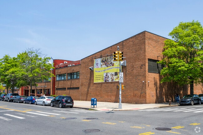
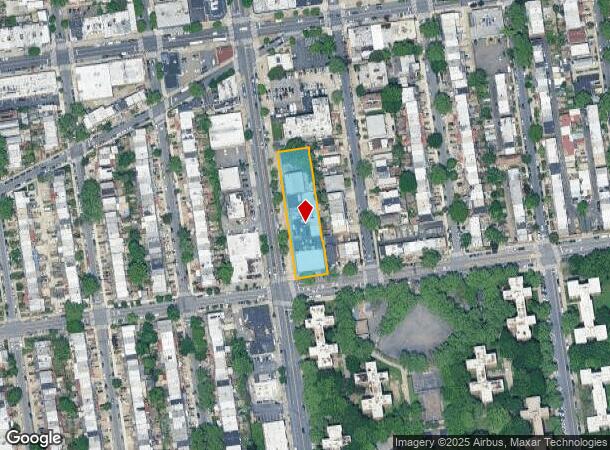
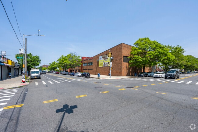
3505 Nostrand Ave, Brooklyn, NY 11229
NEARBY LISTINGS FOR SALE OR LEASE
Property Detail
3505 Nostrand Ave
07363-0036
DOCID-2020010300847001ADDL BLK-LOT: 7363-61
Charitableorganization
Kings
X
New York
3604970352F
36
0
0.75 AC
2025
South Brooklyn
057600
Long Island (New York)
76,000 SF
New York-Jersey City-White Plains, NY-NJ
DEMOGRAPHICS near 3505 Nostrand Ave
1 mile
3 mile
5 mile
2024 Total Population
89,805
628,809
1,452,353
2029 Population
83,077
585,721
1,350,445
Pop Growth 2024-2029
(7.49%)
(6.85%)
(7.02%)
Average Age
43
42
40
2024 Total Households
33,366
222,181
506,294
HH Growth 2024-2029
(7.92%)
(7.20%)
(7.32%)
Median Household Inc
$70,576
$66,042
$62,307
Avg Household Size
2.60
2.70
2.70
2024 Avg HH Vehicles
1.00
1.00
1.00
Median Home Value
$707,071
$748,292
$772,176
Median Year Built
1948
1949
1948
Nearby Places
Map Layers
Map Styles
 Street
 Aerial
Transit
 Traffic
 Biking
Places
Listings with unknown addresses are not visible on the map
- Restaurants
- Banks
- Shops
- Fitness
- Groceries
PUBLIC TRANSPORTATION
TRANSIT/SUBWAY
Neck Road (Q - New York MTA Subway (The Subway))
Drive
Walk
Distance
Neck Road (Q - New York MTA Subway (The Subway))
4 min
16 min
0.8 mi
Avenue U (Q Line) (Q - New York MTA Subway (The Subway))
Drive
Walk
Distance
Avenue U (Q Line) (Q - New York MTA Subway (The Subway))
2 min
17 min
0.8 mi
COMMUTER RAIL
East New York Station (Far Rockaway Branch - Long Island Rail Road, Long Beach Branch - Long Island Rail Road, West Hempstead Branch - Long Island Rail Road)
Drive
Walk
Distance
East New York Station (Far Rockaway Branch - Long Island Rail Road, Long Beach Branch - Long Island Rail Road, West Hempstead Branch - Long Island Rail Road)
12 min
6.4 mi
Drive
Walk
Distance
17 min
6.6 mi
AIRPORT
John F Kennedy International
Drive
Walk
Distance
John F Kennedy International
22 min
14.5 mi
LaGuardia
Drive
Walk
Distance
LaGuardia
32 min
14.7 mi
Newark Liberty International
Drive
Walk
Distance
Newark Liberty International
40 min
22.7 mi
Freight Ports
NY - Red Hook Container Terminal
Drive
Walk
Distance
NY - Red Hook Container Terminal
16 min
8.1 mi
Nearby Properties
Address
Land Use
TOTAL SIZE
Lot Size
Zoning
Address
Land Use
TOTAL SIZE
Lot Size
Zoning
100 SF
1,207.35 AC
M1-1
Address
Land Use
TOTAL SIZE
Lot Size
Zoning
1,281,577 SF
20.78 AC
M3-1
Address
Land Use
TOTAL SIZE
Lot Size
Zoning
1,078,317 SF
10.45 AC
R4
Address
Land Use
TOTAL SIZE
Lot Size
Zoning
5,800 SF
20.10 AC
R6
Address
Land Use
TOTAL SIZE
Lot Size
Zoning
5,800 SF
20.10 AC
R6
Address
Land Use
TOTAL SIZE
Lot Size
Zoning
5,800 SF
20.10 AC
R6
Address
Land Use
TOTAL SIZE
Lot Size
Zoning
5,800 SF
20.10 AC
R6
Address
Land Use
TOTAL SIZE
Lot Size
Zoning
5,800 SF
20.10 AC
R6
Address
Land Use
TOTAL SIZE
Lot Size
Zoning
5,800 SF
20.10 AC
R6
Address
Land Use
TOTAL SIZE
Lot Size
Zoning
5,800 SF
20.10 AC
R6
Address
Land Use
TOTAL SIZE
Lot Size
Zoning
5,800 SF
20.10 AC
R6
Address
Land Use
TOTAL SIZE
Lot Size
Zoning
5,800 SF
20.10 AC
R6
Address
Land Use
TOTAL SIZE
Lot Size
Zoning
530.51 AC
R4-1
Address
Land Use
TOTAL SIZE
Lot Size
Zoning
12.39 AC
R6
Address
Land Use
TOTAL SIZE
Lot Size
Zoning
10,250 SF
773.50 AC
PARK
Address
Land Use
TOTAL SIZE
Lot Size
Zoning
965,600 SF
6.65 AC
R5
Address
Land Use
TOTAL SIZE
Lot Size
Zoning
1,073,920 SF
16.53 AC
R6
Address
Land Use
TOTAL SIZE
Lot Size
Zoning
61.60 AC
PARK
Address
Land Use
TOTAL SIZE
Lot Size
Zoning
54.78 AC
PARK
Address
Land Use
TOTAL SIZE
Lot Size
Zoning
785,450 SF
14.22 AC
R6
Address
Land Use
TOTAL SIZE
Lot Size
Zoning
353,600 SF
55.79 AC
R3-1
Address
Land Use
TOTAL SIZE
Lot Size
Zoning
1,800,000 SF
12.39 AC
R6
Address
Land Use
TOTAL SIZE
Lot Size
Zoning
1,736,700 SF
20.10 AC
R6
Address
Land Use
TOTAL SIZE
Lot Size
Zoning
753,367 SF
5.11 AC
R6
Address
Land Use
TOTAL SIZE
Lot Size
Zoning
623,806 SF
4.68 AC
R6
Address
Land Use
TOTAL SIZE
Lot Size
Zoning
623,806 SF
4.68 AC
R6
Address
Land Use
TOTAL SIZE
Lot Size
Zoning
623,806 SF
4.68 AC
R6
Address
Land Use
TOTAL SIZE
Lot Size
Zoning
623,806 SF
4.68 AC
R6
Address
Land Use
TOTAL SIZE
Lot Size
Zoning
623,806 SF
4.68 AC
R6
Address
Land Use
TOTAL SIZE
Lot Size
Zoning
623,806 SF
4.68 AC
R6
The World's #1 Commercial Real Estate Marketplace
Connect with us
© 2026 CoStar Group
The information above has been obtained from sources believed reliable. While we do not doubt its accuracy we have not verified it and make no guarantee, warranty or representation about it. It is your responsibility to independently confirm its accuracy and completeness. Any projections, opinions, assumptions, or estimates used are for example only and do not represent the current or future performance of the property. The value of this transaction to you depends on tax and other factors which should be evaluated by your tax, financial, and legal advisors. You and your advisors should conduct a careful, independent investigation of the property to determine to your satisfaction the suitability of the property for your needs.