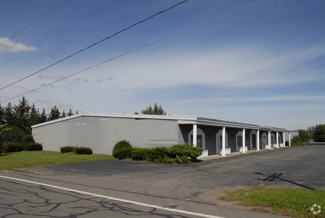
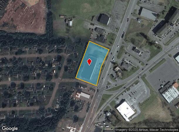
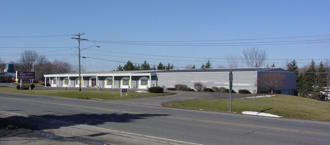
Property Record
3505 West Rd, Cortland, NY 13045
NEARBY LISTINGS FOR SALE OR LEASE
Property Detail
3505 West Rd
112289-095-016-0001-024-100-0000
Cortland
Communitycenter
New York
X
24.100
36023C0229D
1.80 AC
2025
Cortland County
2024
Syracuse
971000
Cortland, NY
19,620 SF
DEMOGRAPHICS near 3505 West Rd
1 Mile
3 Mile
5 Mile
2024 Total Population
2,674
21,088
30,299
2029 Population
2,630
20,881
29,691
Pop Growth 2024-2029
(1.65%)
(0.98%)
(2.01%)
Average Age
39
38
39
2024 Total Households
1,016
8,026
11,791
HH Growth 2024-2029
(1.87%)
(1.01%)
(2.19%)
Median Household Inc
$61,533
$57,367
$58,830
Avg Household Size
2.00
2.10
2.20
2024 Avg HH Vehicles
2.00
2.00
2.00
Median Home Value
$144,070
$147,008
$148,625
Median Year Built
1968
1952
1954
Nearby Places
Map Layers
Map Styles
 Street
 Aerial
- Restaurants
- Banks
- Shops
- Fitness
- Groceries
PUBLIC TRANSPORTATION
AIRPORT
Ithaca Tompkins International
DRIVE
WALK
Distance
Ithaca Tompkins International
30 min
17.1 mi
SALE & LEASE HISTORY
LISTING DATE
SALE/LEASE

Oct 31, 2024
For Lease
Nearby Properties
Address
Land Use
TOTAL SIZE
Lot Size
Zoning
Address
Land Use
TOTAL SIZE
Lot Size
Zoning
224,991 SF
6.70 AC
05 - COMME
Address
Land Use
TOTAL SIZE
Lot Size
Zoning
17,080 SF
74.40 AC
05 - COMME
Address
Land Use
TOTAL SIZE
Lot Size
Zoning
162,556 SF
22.70 AC
05 - COMME
Address
Land Use
TOTAL SIZE
Lot Size
Zoning
138,432 SF
1.01 AC
08 - GOVER
Address
Land Use
TOTAL SIZE
Lot Size
Zoning
56,160 SF
4.60 AC
08 - GOVER
Address
Land Use
TOTAL SIZE
Lot Size
Zoning
221,453 SF
27.71 AC
B1
Address
Land Use
TOTAL SIZE
Lot Size
Zoning
111,968 SF
2.80 AC
08 - GOVER
Address
Land Use
TOTAL SIZE
Lot Size
Zoning
99,000 SF
7.30 AC
08 - GOVER
Address
Land Use
TOTAL SIZE
Lot Size
Zoning
107,712 SF
4.77 AC
05 - COMME
Address
Land Use
TOTAL SIZE
Lot Size
Zoning
85,324 SF
4 AC
08 - GOVER
Address
Land Use
TOTAL SIZE
Lot Size
Zoning
51,750 SF
15.10 AC
08 - GOVER
Address
Land Use
TOTAL SIZE
Lot Size
Zoning
189,440 SF
20.62 AC
05 - COMME
Address
Land Use
TOTAL SIZE
Lot Size
Zoning
42,508 SF
3.60 AC
08 - GOVER
Address
Land Use
TOTAL SIZE
Lot Size
Zoning
107,712 SF
4.77 AC
05 - COMME
Address
Land Use
TOTAL SIZE
Lot Size
Zoning
73,182 SF
2.60 AC
08 - GOVER
Address
Land Use
TOTAL SIZE
Lot Size
Zoning
72,536 SF
2 AC
08 - GOVER
Address
Land Use
TOTAL SIZE
Lot Size
Zoning
81,680 SF
05 - COMME
Address
Land Use
TOTAL SIZE
Lot Size
Zoning
96,605 SF
3.08 AC
05 - COMME
Address
Land Use
TOTAL SIZE
Lot Size
Zoning
30,606 SF
78.50 AC
IN
Address
Land Use
TOTAL SIZE
Lot Size
Zoning
438,796 SF
15.63 AC
05 - COMME
Address
Land Use
TOTAL SIZE
Lot Size
Zoning
111,240 SF
13.41 AC
05 - COMME
Address
Land Use
TOTAL SIZE
Lot Size
Zoning
12,402 SF
5 AC
03 - MULTI
Address
Land Use
TOTAL SIZE
Lot Size
Zoning
33,520 SF
3.50 AC
08 - GOVER
Address
Land Use
TOTAL SIZE
Lot Size
Zoning
74,712 SF
1.50 AC
05 - COMME
Address
Land Use
TOTAL SIZE
Lot Size
Zoning
71,348 SF
5.90 AC
08 - GOVER
Address
Land Use
TOTAL SIZE
Lot Size
Zoning
18,960 SF
0.52 AC
08 - GOVER
Address
Land Use
TOTAL SIZE
Lot Size
Zoning
86,540 SF
1.40 AC
05 - COMME
Address
Land Use
TOTAL SIZE
Lot Size
Zoning
Address
Land Use
TOTAL SIZE
Lot Size
Zoning
7.38 AC
The World's #1 Commercial Real Estate Marketplace
Connect with us
© 2026 CoStar Group
The information above has been obtained from sources believed reliable. While we do not doubt its accuracy we have not verified it and make no guarantee, warranty or representation about it. It is your responsibility to independently confirm its accuracy and completeness. Any projections, opinions, assumptions, or estimates used are for example only and do not represent the current or future performance of the property. The value of this transaction to you depends on tax and other factors which should be evaluated by your tax, financial, and legal advisors. You and your advisors should conduct a careful, independent investigation of the property to determine to your satisfaction the suitability of the property for your needs.