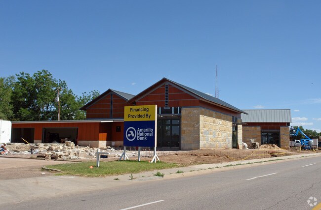
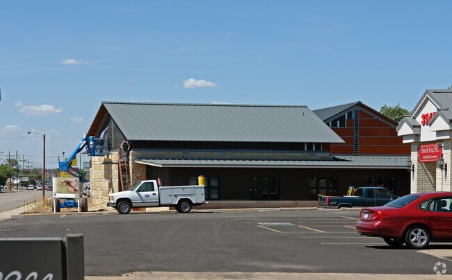
Property Record
3505 S Georgia St, Amarillo, TX 79109

Property Detail
3505 S Georgia St
R-018-5000-0600-0
EDGEHILL ADDN # 5, BLK 0004, 10 &11 EDGEHILL ADDN # 7 LOT 0012-A BLOCK 0004, 0.7700 ACRES
Officebuilding
RANDALL
O
Texas
B and X Area of moderate flood hazard, usually the area between the limits of the 100-year and 500-year floods.
0012-
2024
0.77 AC
2025
Amarillo
020400
Other Market Areas
6,720 SF
Amarillo, TX
NEARBY LISTINGS FOR SALE OR LEASE
DEMOGRAPHICS near 3505 S Georgia St
1 mile
3 mile
5 mile
2024 Total Population
13,124
96,091
169,014
2029 Population
13,626
98,386
172,988
Pop Growth 2024-2029
+ 3.83%
+ 2.39%
+ 2.35%
Average Age
38
38
39
2024 Total Households
5,619
40,282
68,435
HH Growth 2024-2029
+ 3.63%
+ 2.35%
+ 2.34%
Median Household Inc
$57,244
$58,844
$63,319
Avg Household Size
2.30
2.30
2.40
2024 Avg HH Vehicles
2.00
2.00
2.00
Median Home Value
$172,012
$186,788
$201,834
Median Year Built
1963
1968
1973
Nearby Places
Map Layers
Map Styles
 Street
 Aerial
Transit
 Traffic
 Biking
Places
Listings with unknown addresses are not visible on the map
- Restaurants
- Banks
- Shops
- Fitness
- Groceries
PUBLIC TRANSPORTATION
AIRPORT
Rick Husband Amarillo International
Drive
Walk
Distance
Rick Husband Amarillo International
18 min
11.5 mi
Freight Ports
Tulsa Port Of Catoosa
Drive
Walk
Distance
Tulsa Port Of Catoosa
400 min
379.5 mi
Nearby Properties
Address
Land Use
TOTAL SIZE
Lot Size
Zoning
Address
Land Use
TOTAL SIZE
Lot Size
Zoning
431,320 SF
14.82 AC
1F2 S
Address
Land Use
TOTAL SIZE
Lot Size
Zoning
342,930 SF
34.57 AC
PD
Address
Land Use
TOTAL SIZE
Lot Size
Zoning
250,705 SF
2.07 AC
CB
Address
Land Use
TOTAL SIZE
Lot Size
Zoning
168,978 SF
4.23 AC
1F2 S
Address
Land Use
TOTAL SIZE
Lot Size
Zoning
350,459 SF
10.71 AC
Address
Land Use
TOTAL SIZE
Lot Size
Zoning
2,419 SF
8.93 AC
PD
Address
Land Use
TOTAL SIZE
Lot Size
Zoning
207,120 SF
16.54 AC
GR
Address
Land Use
TOTAL SIZE
Lot Size
Zoning
345,555 SF
23.69 AC
PD
Address
Land Use
TOTAL SIZE
Lot Size
Zoning
116,842 SF
4.17 AC
Address
Land Use
TOTAL SIZE
Lot Size
Zoning
45,380 SF
2.62 AC
Address
Land Use
TOTAL SIZE
Lot Size
Zoning
254,693 SF
5.24 AC
LC
Address
Land Use
TOTAL SIZE
Lot Size
Zoning
367,924 SF
39.99 AC
PD
Address
Land Use
TOTAL SIZE
Lot Size
Zoning
371,536 SF
2.07 AC
CB
Address
Land Use
TOTAL SIZE
Lot Size
Zoning
145,652 SF
20.53 AC
Address
Land Use
TOTAL SIZE
Lot Size
Zoning
133,279 SF
2.07 AC
CB
Address
Land Use
TOTAL SIZE
Lot Size
Zoning
229,869 SF
10.85 AC
Address
Land Use
TOTAL SIZE
Lot Size
Zoning
168,130 SF
16.32 AC
Address
Land Use
TOTAL SIZE
Lot Size
Zoning
182,242 SF
20.70 AC
Address
Land Use
TOTAL SIZE
Lot Size
Zoning
210,217 SF
10.49 AC
M11
Address
Land Use
TOTAL SIZE
Lot Size
Zoning
100,350 SF
1.24 AC
CB
Address
Land Use
TOTAL SIZE
Lot Size
Zoning
125,357 SF
4.34 AC
LC
Address
Land Use
TOTAL SIZE
Lot Size
Zoning
204,468 SF
17.56 AC
Address
Land Use
TOTAL SIZE
Lot Size
Zoning
80,298 SF
7.75 AC
Address
Land Use
TOTAL SIZE
Lot Size
Zoning
99,739 SF
3.88 AC
R2
Address
Land Use
TOTAL SIZE
Lot Size
Zoning
167,257 SF
12.66 AC
Address
Land Use
TOTAL SIZE
Lot Size
Zoning
388,909 SF
2.07 AC
CB
Address
Land Use
TOTAL SIZE
Lot Size
Zoning
77,549 SF
0.19 AC
CB
Address
Land Use
TOTAL SIZE
Lot Size
Zoning
112,005 SF
7.70 AC
GR
Address
Land Use
TOTAL SIZE
Lot Size
Zoning
110,796 SF
0.55 AC
MF2
Address
Land Use
TOTAL SIZE
Lot Size
Zoning
193,004 SF
The World's #1 Commercial Real Estate Marketplace
Connect with us
© 2026 CoStar Group
The information above has been obtained from sources believed reliable. While we do not doubt its accuracy we have not verified it and make no guarantee, warranty or representation about it. It is your responsibility to independently confirm its accuracy and completeness. Any projections, opinions, assumptions, or estimates used are for example only and do not represent the current or future performance of the property. The value of this transaction to you depends on tax and other factors which should be evaluated by your tax, financial, and legal advisors. You and your advisors should conduct a careful, independent investigation of the property to determine to your satisfaction the suitability of the property for your needs.