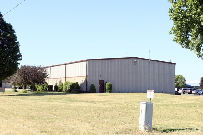
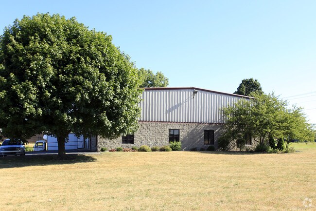
Property Record
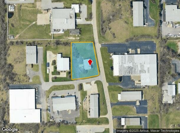
3505 W Mcgill St, South Bend, IN 46628
NEARBY LISTINGS FOR SALE OR LEASE
Property Detail
3505 W Mcgill St
71-03-28-201-009.000-009
1.87 AC TRACT W SIDE OF KENMORE N SIDE OF MCGILL NE SEC 28 38 2E
Warehouse
St Joseph
X
Indiana
18141C0181D
1.87 AC
2023
Greater South Bend
2024
South Bend/Mishawaka
011001
South Bend-Mishawaka, IN-MI
6,500 SF
DEMOGRAPHICS near 3505 W Mcgill St
1 Mile
3 Mile
5 Mile
2024 Total Population
2,984
35,471
109,462
2029 Population
2,944
35,554
109,892
Pop Growth 2024-2029
(1.34%)
+ 0.23%
+ 0.39%
Average Age
39
38
37
2024 Total Households
1,467
13,742
40,669
HH Growth 2024-2029
(1.43%)
+ 0.06%
+ 0.42%
Median Household Inc
$36,535
$50,998
$53,772
Avg Household Size
2.00
2.40
2.40
2024 Avg HH Vehicles
1.00
2.00
2.00
Median Home Value
$160,730
$132,990
$147,321
Median Year Built
1978
1961
1962
Nearby Places
Map Layers
Map Styles
 Street
 Aerial
- Restaurants
- Banks
- Shops
- Fitness
- Groceries
PUBLIC TRANSPORTATION
COMMUTER RAIL
South Bend Airport Station (South Shore Line - Northern Indiana Commuter Transportation District (South Shore Line))
DRIVE
WALK
Distance
South Bend Airport Station (South Shore Line - Northern Indiana Commuter Transportation District (South Shore Line))
9 min
2.8 mi
DRIVE
WALK
Distance
9 min
3.6 mi
AIRPORT
South Bend International
DRIVE
WALK
Distance
South Bend International
19 min
5.8 mi
Nearby Properties
Address
Land Use
TOTAL SIZE
Lot Size
Zoning
Address
Land Use
TOTAL SIZE
Lot Size
Zoning
315,000 SF
131 SF
Address
Land Use
TOTAL SIZE
Lot Size
Zoning
538,338 SF
0.01 AC
Address
Land Use
TOTAL SIZE
Lot Size
Zoning
25,756 SF
337.40 AC
Address
Land Use
TOTAL SIZE
Lot Size
Zoning
356,520 SF
28.07 AC
Address
Land Use
TOTAL SIZE
Lot Size
Zoning
174,997 SF
0.70 AC
Address
Land Use
TOTAL SIZE
Lot Size
Zoning
252,327 SF
131 SF
Address
Land Use
TOTAL SIZE
Lot Size
Zoning
128,298 SF
0.84 AC
Address
Land Use
TOTAL SIZE
Lot Size
Zoning
747,842 SF
30.05 AC
Address
Land Use
TOTAL SIZE
Lot Size
Zoning
142,065 SF
44 SF
Address
Land Use
TOTAL SIZE
Lot Size
Zoning
232,200 SF
87 SF
Address
Land Use
TOTAL SIZE
Lot Size
Zoning
159,834 SF
44 SF
Address
Land Use
TOTAL SIZE
Lot Size
Zoning
633,966 SF
87 SF
Address
Land Use
TOTAL SIZE
Lot Size
Zoning
296,370 SF
131 SF
Address
Land Use
TOTAL SIZE
Lot Size
Zoning
157,702 SF
44 SF
Address
Land Use
TOTAL SIZE
Lot Size
Zoning
213,400 SF
44 SF
Address
Land Use
TOTAL SIZE
Lot Size
Zoning
166,500 SF
44 SF
Address
Land Use
TOTAL SIZE
Lot Size
Zoning
114,844 SF
4.17 AC
Address
Land Use
TOTAL SIZE
Lot Size
Zoning
225,000 SF
19.59 AC
Address
Land Use
TOTAL SIZE
Lot Size
Zoning
210,420 SF
131 SF
Address
Land Use
TOTAL SIZE
Lot Size
Zoning
212,497 SF
131 SF
Address
Land Use
TOTAL SIZE
Lot Size
Zoning
210,420 SF
131 SF
Address
Land Use
TOTAL SIZE
Lot Size
Zoning
111,803 SF
7.45 AC
Address
Land Use
TOTAL SIZE
Lot Size
Zoning
63,780 SF
44 SF
Address
Land Use
TOTAL SIZE
Lot Size
Zoning
178,316 SF
44 SF
Address
Land Use
TOTAL SIZE
Lot Size
Zoning
72,418 SF
131 SF
Address
Land Use
TOTAL SIZE
Lot Size
Zoning
214,657 SF
131 SF
Address
Land Use
TOTAL SIZE
Lot Size
Zoning
79,451 SF
87 SF
Address
Land Use
TOTAL SIZE
Lot Size
Zoning
4,428 SF
0.02 AC
Address
Land Use
TOTAL SIZE
Lot Size
Zoning
203,750 SF
22.36 AC
Address
Land Use
TOTAL SIZE
Lot Size
Zoning
204,880 SF
44 SF
The World's #1 Commercial Real Estate Marketplace
Connect with us
© 2025 CoStar Group
The information above has been obtained from sources believed reliable. While we do not doubt its accuracy we have not verified it and make no guarantee, warranty or representation about it. It is your responsibility to independently confirm its accuracy and completeness. Any projections, opinions, assumptions, or estimates used are for example only and do not represent the current or future performance of the property. The value of this transaction to you depends on tax and other factors which should be evaluated by your tax, financial, and legal advisors. You and your advisors should conduct a careful, independent investigation of the property to determine to your satisfaction the suitability of the property for your needs.