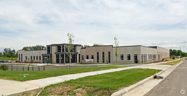
Property Record
3506 Mcallens Way, Madison, WI 53718

NEARBY LISTINGS FOR SALE OR LEASE
Property Detail
3506 Mcallens Way
Madison, WI
Certified Survey Map No 14279 As
0710-234-0202-8
MCALLEN 120 BUSINESS PARK PLAT, LOT 4.
Commercialnec
Dane
X
Wisconsin
55025C0442H
4
2024
4.55 AC
2024
Outlying Dane East
011406
Milwaukee/Madison
50,878 SF
DEMOGRAPHICS near 3506 Mcallens Way
1 Mile
3 Mile
5 Mile
2024 Total Population
92
30,192
81,068
2029 Population
94
31,255
84,261
Pop Growth 2024-2029
+ 2.17%
+ 3.52%
+ 3.94%
Average Age
47
41
41
2024 Total Households
47
12,760
34,700
HH Growth 2024-2029
+ 2.13%
+ 3.60%
+ 4.00%
Median Household Inc
$63,750
$86,579
$82,470
Avg Household Size
2.00
2.30
2.30
2024 Avg HH Vehicles
2.00
2.00
2.00
Median Home Value
$285,713
$298,081
$302,571
Median Year Built
1993
1989
1981
Nearby Places
Map Layers
Map Styles
 Street
 Aerial
- Restaurants
- Banks
- Shops
- Fitness
- Groceries
PUBLIC TRANSPORTATION
AIRPORT
Dane County Regional/Truax Field
DRIVE
WALK
Distance
Dane County Regional/Truax Field
18 min
10.3 mi
Freight Ports
Port Milwaukee
DRIVE
WALK
Distance
Port Milwaukee
95 min
80.6 mi
SALE & LEASE HISTORY
LISTING DATE
SALE/LEASE

Feb 08, 2018
For Lease
Nearby Properties
Address
Land Use
TOTAL SIZE
Lot Size
Zoning
Address
Land Use
TOTAL SIZE
Lot Size
Zoning
168,685 SF
14.05 AC
IL
Address
Land Use
TOTAL SIZE
Lot Size
Zoning
13,440 SF
10.98 AC
IL
Address
Land Use
TOTAL SIZE
Lot Size
Zoning
3.59 AC
Address
Land Use
TOTAL SIZE
Lot Size
Zoning
12,450 SF
9.40 AC
SE
Address
Land Use
TOTAL SIZE
Lot Size
Zoning
225,108 SF
2 AC
PD
Address
Land Use
TOTAL SIZE
Lot Size
Zoning
19.81 AC
Address
Land Use
TOTAL SIZE
Lot Size
Zoning
149,897 SF
17.72 AC
IL
Address
Land Use
TOTAL SIZE
Lot Size
Zoning
5.53 AC
Address
Land Use
TOTAL SIZE
Lot Size
Zoning
3.49 AC
Address
Land Use
TOTAL SIZE
Lot Size
Zoning
6,868 SF
18.35 AC
IL
Address
Land Use
TOTAL SIZE
Lot Size
Zoning
167,519 SF
4.51 AC
PD
Address
Land Use
TOTAL SIZE
Lot Size
Zoning
202,800 SF
13.05 AC
IL
Address
Land Use
TOTAL SIZE
Lot Size
Zoning
154,403 SF
1.21 AC
PD
Address
Land Use
TOTAL SIZE
Lot Size
Zoning
217,952 SF
6.47 AC
PD
Address
Land Use
TOTAL SIZE
Lot Size
Zoning
176,496 SF
3.51 AC
PD
Address
Land Use
TOTAL SIZE
Lot Size
Zoning
156,368 SF
4.01 AC
PD
Address
Land Use
TOTAL SIZE
Lot Size
Zoning
16.40 AC
IL
Address
Land Use
TOTAL SIZE
Lot Size
Zoning
280,000 SF
15.01 AC
IL
Address
Land Use
TOTAL SIZE
Lot Size
Zoning
10.45 AC
IL
Address
Land Use
TOTAL SIZE
Lot Size
Zoning
49,562 SF
4.42 AC
SE
Address
Land Use
TOTAL SIZE
Lot Size
Zoning
17,980 SF
6.25 AC
SR-V2
Address
Land Use
TOTAL SIZE
Lot Size
Zoning
111,768 SF
2.38 AC
PD
Address
Land Use
TOTAL SIZE
Lot Size
Zoning
134,814 SF
3.79 AC
SR-V2
Address
Land Use
TOTAL SIZE
Lot Size
Zoning
9,030 SF
6.59 AC
SR-V2
Address
Land Use
TOTAL SIZE
Lot Size
Zoning
42,967 SF
5.25 AC
SR-V2
Address
Land Use
TOTAL SIZE
Lot Size
Zoning
113,341 SF
11.66 AC
IL
Address
Land Use
TOTAL SIZE
Lot Size
Zoning
131,874 SF
8.98 AC
IL
Address
Land Use
TOTAL SIZE
Lot Size
Zoning
14.34 AC
IL
Address
Land Use
TOTAL SIZE
Lot Size
Zoning
57,601 SF
5.92 AC
PD
The World's #1 Commercial Real Estate Marketplace
Connect with us
© 2026 CoStar Group
The information above has been obtained from sources believed reliable. While we do not doubt its accuracy we have not verified it and make no guarantee, warranty or representation about it. It is your responsibility to independently confirm its accuracy and completeness. Any projections, opinions, assumptions, or estimates used are for example only and do not represent the current or future performance of the property. The value of this transaction to you depends on tax and other factors which should be evaluated by your tax, financial, and legal advisors. You and your advisors should conduct a careful, independent investigation of the property to determine to your satisfaction the suitability of the property for your needs.