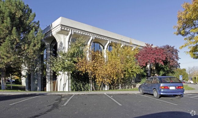
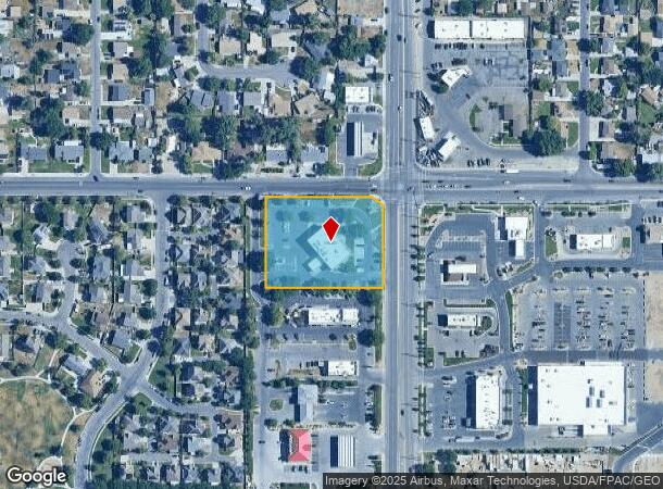
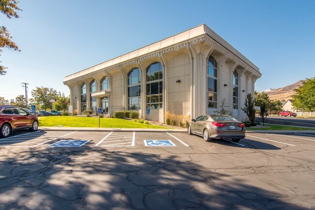
Property Record
3506 S 8400 W, Magna, UT 84044
NEARBY LISTINGS FOR SALE OR LEASE
Property Detail
3506 S 8400 W
14-32-126-011-0000
BEG N 89^3544 W 68.4 FT & S 0^0825 W 33 FT FR N 1/4 COR SEC 32, T 1S, R 2W, SLM; N 89^3544 W 292.28 FT; S 0^0825W 250 FT; S 89^3544 E 321.39 FT; N 0^0825 E 226.17 FT; N50^2340 W 37.7 FT TO BEG. 1.84 AC M OR L.
Financialbuilding
Salt Lake
X
Utah
49035C0275G
1.84 AC
2024
West Valley/Lake Park
2025
Salt Lake City
113908
Salt Lake City, UT
19,859 SF
DEMOGRAPHICS near 3506 S 8400 W
1 Mile
3 Mile
5 Mile
2024 Total Population
17,344
49,387
99,251
2029 Population
17,477
49,616
99,708
Pop Growth 2024-2029
+ 0.77%
+ 0.46%
+ 0.46%
Average Age
34
34
35
2024 Total Households
4,994
13,784
26,997
HH Growth 2024-2029
+ 0.66%
+ 0.33%
+ 0.33%
Median Household Inc
$72,421
$79,157
$82,952
Avg Household Size
3.50
3.50
3.60
2024 Avg HH Vehicles
2.00
2.00
3.00
Median Home Value
$323,507
$333,478
$341,865
Median Year Built
1989
1987
1985
Nearby Places
Map Layers
Map Styles
 Street
 Aerial
- Restaurants
- Banks
- Shops
- Fitness
- Groceries
PUBLIC TRANSPORTATION
AIRPORT
Salt Lake City International
DRIVE
WALK
Distance
Salt Lake City International
17 min
11.4 mi
Freight Ports
Port of Stockton
DRIVE
WALK
Distance
Port of Stockton
703 min
686.6 mi
SALE & LEASE HISTORY
LISTING DATE
SALE/LEASE

Oct 11, 2016
For Lease
Nearby Properties
Address
Land Use
TOTAL SIZE
Lot Size
Zoning
Address
Land Use
TOTAL SIZE
Lot Size
Zoning
613,674 SF
1,309.05 AC
M
Address
Land Use
TOTAL SIZE
Lot Size
Zoning
634,402 SF
32.29 AC
IP-M
Address
Land Use
TOTAL SIZE
Lot Size
Zoning
479,807 SF
13.13 AC
P-C
Address
Land Use
TOTAL SIZE
Lot Size
Zoning
832,383 SF
19.61 AC
IP-M
Address
Land Use
TOTAL SIZE
Lot Size
Zoning
89,037 SF
11.79 AC
C-2
Address
Land Use
TOTAL SIZE
Lot Size
Zoning
480,159 SF
56.52 AC
M-1
Address
Land Use
TOTAL SIZE
Lot Size
Zoning
404,800 SF
24.62 AC
M
Address
Land Use
TOTAL SIZE
Lot Size
Zoning
496,431 SF
23.89 AC
IP-M
Address
Land Use
TOTAL SIZE
Lot Size
Zoning
172,016 SF
622.03 AC
M-2
Address
Land Use
TOTAL SIZE
Lot Size
Zoning
418,984 SF
21.65 AC
IP-M
Address
Land Use
TOTAL SIZE
Lot Size
Zoning
159,381 SF
18.82 AC
1106
Address
Land Use
TOTAL SIZE
Lot Size
Zoning
856,805 SF
782.87 AC
A-20
Address
Land Use
TOTAL SIZE
Lot Size
Zoning
54,033 SF
7.28 AC
R-M
Address
Land Use
TOTAL SIZE
Lot Size
Zoning
231,694 SF
20.73 AC
1206
Address
Land Use
TOTAL SIZE
Lot Size
Zoning
328,000 SF
18.04 AC
IP-M
Address
Land Use
TOTAL SIZE
Lot Size
Zoning
58,759 SF
9.82 AC
RM/ZC
Address
Land Use
TOTAL SIZE
Lot Size
Zoning
99,064 SF
5.65 AC
1P-M
Address
Land Use
TOTAL SIZE
Lot Size
Zoning
640 AC
M-2
Address
Land Use
TOTAL SIZE
Lot Size
Zoning
32,500 SF
480 AC
IP-M-2
Address
Land Use
TOTAL SIZE
Lot Size
Zoning
183,638 SF
17.27 AC
1206
Address
Land Use
TOTAL SIZE
Lot Size
Zoning
480 AC
M-2
Address
Land Use
TOTAL SIZE
Lot Size
Zoning
480 AC
M-2
Address
Land Use
TOTAL SIZE
Lot Size
Zoning
338,399 SF
355 AC
M
Address
Land Use
TOTAL SIZE
Lot Size
Zoning
126,060 SF
7.01 AC
1P-M
Address
Land Use
TOTAL SIZE
Lot Size
Zoning
211.48 AC
M
Address
Land Use
TOTAL SIZE
Lot Size
Zoning
120,163 SF
6.69 AC
IP-M
Address
Land Use
TOTAL SIZE
Lot Size
Zoning
173.65 AC
M
Address
Land Use
TOTAL SIZE
Lot Size
Zoning
79,705 SF
14.95 AC
IP-M
Address
Land Use
TOTAL SIZE
Lot Size
Zoning
106,732 SF
20.71 AC
4110
Address
Land Use
TOTAL SIZE
Lot Size
Zoning
80,373 SF
12.68 AC
1107
The World's #1 Commercial Real Estate Marketplace
Connect with us
© 2025 CoStar Group
The information above has been obtained from sources believed reliable. While we do not doubt its accuracy we have not verified it and make no guarantee, warranty or representation about it. It is your responsibility to independently confirm its accuracy and completeness. Any projections, opinions, assumptions, or estimates used are for example only and do not represent the current or future performance of the property. The value of this transaction to you depends on tax and other factors which should be evaluated by your tax, financial, and legal advisors. You and your advisors should conduct a careful, independent investigation of the property to determine to your satisfaction the suitability of the property for your needs.