Property Record
371 S Weber Rd, Romeoville, IL 60446
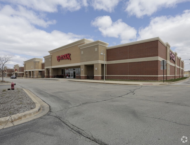

This Property Is For Sale
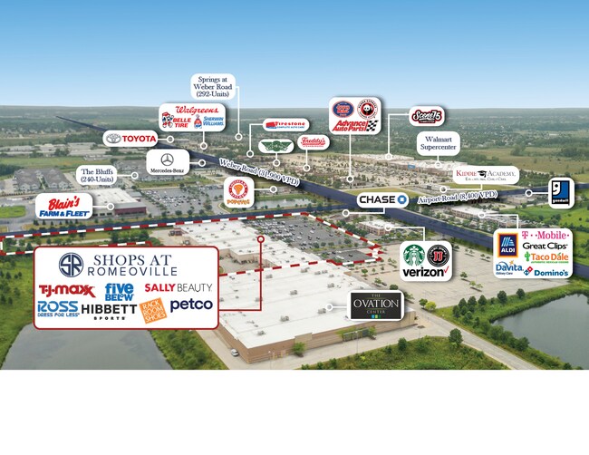
NEARBY LISTINGS FOR SALE OR LEASE
Property Detail
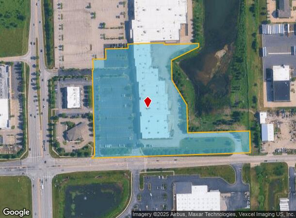
371 S Weber Rd
Chicago-Naperville-Elgin, IL-IN-WI
Rubloff Weber Road Sub
11-04-08-304-010
LOT 1 IN RUBLOFF WEBER ROAD SUB, BEING A SUB OF PRT OF THE SW1/4 OF THE NW1/4 PRT OF THE W1/2 OF THE SW1/4 OF SEC. 8,T36N-R1
Commercialnec
Will
X
Illinois
17197C0155G
1
2024
9.47 AC
2024
Joliet/Central Will
884101
Chicago
DEMOGRAPHICS near 371 S Weber Rd
1 Mile
3 Mile
5 Mile
2024 Total Population
6,548
55,586
146,226
2029 Population
6,542
55,363
145,677
Pop Growth 2024-2029
(0.09%)
(0.40%)
(0.38%)
Average Age
38
40
40
2024 Total Households
2,541
19,502
51,747
HH Growth 2024-2029
+ 0.28%
(0.30%)
(0.36%)
Median Household Inc
$79,761
$85,045
$84,888
Avg Household Size
2.50
2.80
2.70
2024 Avg HH Vehicles
2.00
2.00
2.00
Median Home Value
$220,069
$234,588
$237,650
Median Year Built
2003
1999
1992
Nearby Places
- Restaurants
- Banks
- Shops
- Fitness
- Groceries
PUBLIC TRANSPORTATION
COMMUTER RAIL
Lockport Station (Heritage Corridor Line - Northeast Illinois Regional Commuter Railroad (Metra))
DRIVE
WALK
Distance
Lockport Station (Heritage Corridor Line - Northeast Illinois Regional Commuter Railroad (Metra))
9 min
4.9 mi
Joliet Station (Heritage Corridor Line - Northeast Illinois Regional Commuter Railroad (Metra), Rock Island District Line - Northeast Illinois Regional Commuter Railroad (Metra))
DRIVE
WALK
Distance
Joliet Station (Heritage Corridor Line - Northeast Illinois Regional Commuter Railroad (Metra), Rock Island District Line - Northeast Illinois Regional Commuter Railroad (Metra))
18 min
8.8 mi
AIRPORT
Chicago Midway International
DRIVE
WALK
Distance
Chicago Midway International
34 min
28.3 mi
Chicago O'Hare International
DRIVE
WALK
Distance
Chicago O'Hare International
38 min
35.4 mi
Freight Ports
Port of Baltimore
DRIVE
WALK
Distance
Port of Baltimore
1 min
626.9 mi
Nearby Properties
Address
Land Use
TOTAL SIZE
Lot Size
Zoning
Address
Land Use
TOTAL SIZE
Lot Size
Zoning
21.76 AC
Address
Land Use
TOTAL SIZE
Lot Size
Zoning
59.76 AC
Address
Land Use
TOTAL SIZE
Lot Size
Zoning
Address
Land Use
TOTAL SIZE
Lot Size
Zoning
48.28 AC
Address
Land Use
TOTAL SIZE
Lot Size
Zoning
62.35 AC
Address
Land Use
TOTAL SIZE
Lot Size
Zoning
37.47 AC
Address
Land Use
TOTAL SIZE
Lot Size
Zoning
46.85 AC
Address
Land Use
TOTAL SIZE
Lot Size
Zoning
28.82 AC
Address
Land Use
TOTAL SIZE
Lot Size
Zoning
800,000 SF
43.13 AC
Address
Land Use
TOTAL SIZE
Lot Size
Zoning
715,638 SF
35.12 AC
Address
Land Use
TOTAL SIZE
Lot Size
Zoning
39.75 AC
Address
Land Use
TOTAL SIZE
Lot Size
Zoning
50.08 AC
Address
Land Use
TOTAL SIZE
Lot Size
Zoning
54.90 AC
Address
Land Use
TOTAL SIZE
Lot Size
Zoning
Address
Land Use
TOTAL SIZE
Lot Size
Zoning
965,899 SF
22.17 AC
Address
Land Use
TOTAL SIZE
Lot Size
Zoning
33.74 AC
Address
Land Use
TOTAL SIZE
Lot Size
Zoning
33.95 AC
Address
Land Use
TOTAL SIZE
Lot Size
Zoning
12.84 AC
Address
Land Use
TOTAL SIZE
Lot Size
Zoning
26.25 AC
Address
Land Use
TOTAL SIZE
Lot Size
Zoning
24.14 AC
Address
Land Use
TOTAL SIZE
Lot Size
Zoning
21.96 AC
Address
Land Use
TOTAL SIZE
Lot Size
Zoning
25.13 AC
Address
Land Use
TOTAL SIZE
Lot Size
Zoning
22.13 AC
Address
Land Use
TOTAL SIZE
Lot Size
Zoning
7.72 AC
Address
Land Use
TOTAL SIZE
Lot Size
Zoning
28.08 AC
Address
Land Use
TOTAL SIZE
Lot Size
Zoning
23.12 AC
Address
Land Use
TOTAL SIZE
Lot Size
Zoning
28.72 AC
Address
Land Use
TOTAL SIZE
Lot Size
Zoning
Address
Land Use
TOTAL SIZE
Lot Size
Zoning
20.50 AC
Address
Land Use
TOTAL SIZE
Lot Size
Zoning
26.02 AC
The World's #1 Commercial Real Estate Marketplace
Connect with us
© 2025 CoStar Group
The information above has been obtained from sources believed reliable. While we do not doubt its accuracy we have not verified it and make no guarantee, warranty or representation about it. It is your responsibility to independently confirm its accuracy and completeness. Any projections, opinions, assumptions, or estimates used are for example only and do not represent the current or future performance of the property. The value of this transaction to you depends on tax and other factors which should be evaluated by your tax, financial, and legal advisors. You and your advisors should conduct a careful, independent investigation of the property to determine to your satisfaction the suitability of the property for your needs.