Property Record
351 Cheryl Ln, Walnut, CA 91789

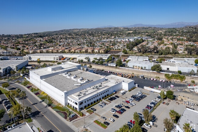

Property Detail
351 Cheryl Ln
8760-025-046
P M 239-67-73 POR OF LOT 15
Foodprocessing
Los Angeles
IDM*
California
B and X Area of moderate flood hazard, usually the area between the limits of the 100-year and 500-year floods.
15
2024
2.89 AC
2025
City of Industry
403327
Los Angeles
83,027 SF
Los Angeles-Long Beach-Glendale, CA
NEARBY LISTINGS FOR SALE OR LEASE
DEMOGRAPHICS near 351 Cheryl Ln
1 mile
3 mile
5 mile
2025 Total Population
8,046
97,574
257,795
2030 Population
7,971
97,198
255,074
Pop Growth 2025-2030
(0.93%)
(0.39%)
(1.06%)
Average Age
43
43
42
2025 Total Households
2,484
30,244
77,035
HH Growth 2025-2030
(1.13%)
(0.57%)
(1.25%)
Median Household Inc
$112,205
$109,354
$104,514
Avg Household Size
3.20
3.10
3.20
2025 Avg HH Vehicles
3.00
2.00
2.00
Median Home Value
$847,195
$848,402
$813,017
Median Year Built
1976
1978
1976
Nearby Places
Map Layers
Map Styles
 Street
 Aerial
Layers
 Traffic
 Biking
Places
Listings with unknown addresses are not visible on the map
- Restaurants
- Banks
- Shops
- Fitness
- Groceries
PUBLIC TRANSPORTATION
COMMUTER RAIL
Industry (Riverside Line - Southern California Regional Rail Authority (Metrolink))
Drive
Walk
Distance
Industry (Riverside Line - Southern California Regional Rail Authority (Metrolink))
2 min
13 min
0.7 mi
Covina (San Bernardino Line - Southern California Regional Rail Authority (Metrolink))
Drive
Walk
Distance
Covina (San Bernardino Line - Southern California Regional Rail Authority (Metrolink))
14 min
7.8 mi
AIRPORT
Ontario International
Drive
Walk
Distance
Ontario International
26 min
18.4 mi
John Wayne/Orange County
Drive
Walk
Distance
John Wayne/Orange County
34 min
26.8 mi
Long Beach (Daugherty Field)
Drive
Walk
Distance
Long Beach (Daugherty Field)
44 min
33.1 mi
Freight Ports
Port of Long Beach
Drive
Walk
Distance
Port of Long Beach
50 min
35.8 mi
SALE & LEASE HISTORY
LISTING DATE
SALE/LEASE

Sep 05, 2019
For Lease
Aug 26, 2019
For Sale
Nearby Properties
Address
Land Use
TOTAL SIZE
Lot Size
Zoning
Address
Land Use
TOTAL SIZE
Lot Size
Zoning
221,018 SF
26.87 AC
IDM*
Address
Land Use
TOTAL SIZE
Lot Size
Zoning
996,725 SF
33.01 AC
1DM*
Address
Land Use
TOTAL SIZE
Lot Size
Zoning
183,668 SF
12.59 AC
RM
Address
Land Use
TOTAL SIZE
Lot Size
Zoning
146,466 SF
6.99 AC
IDM*
Address
Land Use
TOTAL SIZE
Lot Size
Zoning
1,092,435 SF
28.50 AC
Address
Land Use
TOTAL SIZE
Lot Size
Zoning
498,696 SF
22.90 AC
1DM*
Address
Land Use
TOTAL SIZE
Lot Size
Zoning
118,432 SF
10.71 AC
LCR19000*
Address
Land Use
TOTAL SIZE
Lot Size
Zoning
887,697 SF
21.59 AC
IDM*
Address
Land Use
TOTAL SIZE
Lot Size
Zoning
595,025 SF
28.42 AC
IDM*
Address
Land Use
TOTAL SIZE
Lot Size
Zoning
950,576 SF
24.53 AC
IDM*
Address
Land Use
TOTAL SIZE
Lot Size
Zoning
80,608 SF
5.34 AC
WCPCD1*
Address
Land Use
TOTAL SIZE
Lot Size
Zoning
80,608 SF
4.80 AC
WCPCD1*
Address
Land Use
TOTAL SIZE
Lot Size
Zoning
81,072 SF
4.95 AC
WCPCD1*
Address
Land Use
TOTAL SIZE
Lot Size
Zoning
409,249 SF
4.64 AC
LCR110000*
Address
Land Use
TOTAL SIZE
Lot Size
Zoning
799,910 SF
39.11 AC
IDM*
Address
Land Use
TOTAL SIZE
Lot Size
Zoning
140,956 SF
4.74 AC
WAC3*
Address
Land Use
TOTAL SIZE
Lot Size
Zoning
557,950 SF
12.45 AC
POM2
Address
Land Use
TOTAL SIZE
Lot Size
Zoning
466,575 SF
15.38 AC
IDM*
Address
Land Use
TOTAL SIZE
Lot Size
Zoning
130,850 SF
11.45 AC
LCC3
Address
Land Use
TOTAL SIZE
Lot Size
Zoning
49,080 SF
1.56 AC
LCA12L
Address
Land Use
TOTAL SIZE
Lot Size
Zoning
650,025 SF
31.69 AC
IDM*
Address
Land Use
TOTAL SIZE
Lot Size
Zoning
68,313 SF
10.02 AC
LCR110000*
Address
Land Use
TOTAL SIZE
Lot Size
Zoning
Address
Land Use
TOTAL SIZE
Lot Size
Zoning
300,366 SF
13.48 AC
1DM*
Address
Land Use
TOTAL SIZE
Lot Size
Zoning
462,081 SF
9.75 AC
LCC2BE*
Address
Land Use
TOTAL SIZE
Lot Size
Zoning
250,999 SF
10.42 AC
1DM*
Address
Land Use
TOTAL SIZE
Lot Size
Zoning
275,220 SF
13.07 AC
1DM*
Address
Land Use
TOTAL SIZE
Lot Size
Zoning
350,936 SF
8.35 AC
WAC3*
Address
Land Use
TOTAL SIZE
Lot Size
Zoning
95,109 SF
7.24 AC
LCCPD*
The World's #1 Commercial Real Estate Marketplace
Connect with us
© 2026 CoStar Group
The information above has been obtained from sources believed reliable. While we do not doubt its accuracy we have not verified it and make no guarantee, warranty or representation about it. It is your responsibility to independently confirm its accuracy and completeness. Any projections, opinions, assumptions, or estimates used are for example only and do not represent the current or future performance of the property. The value of this transaction to you depends on tax and other factors which should be evaluated by your tax, financial, and legal advisors. You and your advisors should conduct a careful, independent investigation of the property to determine to your satisfaction the suitability of the property for your needs.