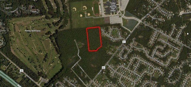
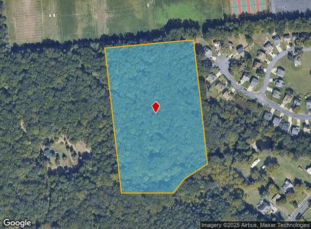
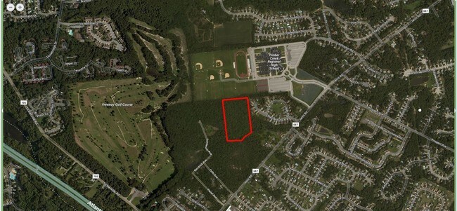
Property Record
351 Jarvis Rd, Sicklerville, NJ 08081

NEARBY LISTINGS FOR SALE OR LEASE
Property Detail
351 Jarvis Rd
Philadelphia-Camden-Wilmington, PA-NJ-DE-MD
ADDITIONAL LOTS: ANNEX TO TCHS/FACILITY NAME: SCHOOLS
15-15805-0000-00046
Camden
Publicschool
New Jersey
X
46
34015C0119E
10 AC
0
South Camden County
2025
Philadelphia
608404
DEMOGRAPHICS near 351 Jarvis Rd
1 mile
3 mile
5 mile
2024 Total Population
9,246
69,967
181,499
2029 Population
9,267
70,527
183,164
Pop Growth 2024-2029
+ 0.23%
+ 0.80%
+ 0.92%
Average Age
39
40
40
2024 Total Households
3,299
25,422
69,095
HH Growth 2024-2029
+ 0.27%
+ 0.87%
+ 0.91%
Median Household Inc
$108,014
$94,487
$85,164
Avg Household Size
2.70
2.70
2.60
2024 Avg HH Vehicles
2.00
2.00
2.00
Median Home Value
$247,492
$251,940
$243,960
Median Year Built
1986
1982
1978
Nearby Places
Map Layers
Map Styles
 Street
 Aerial
Transit
 Traffic
 Biking
Places
Listings with unknown addresses are not visible on the map
- Restaurants
- Banks
- Shops
- Fitness
- Groceries
PUBLIC TRANSPORTATION
COMMUTER RAIL
Lindenwold (NJT) (Atlantic City Line - NJ Transit Commuter Rail (NJ Transit))
Drive
Walk
Distance
Lindenwold (NJT) (Atlantic City Line - NJ Transit Commuter Rail (NJ Transit))
15 min
6.5 mi
Atco (Atlantic City Line - NJ Transit Commuter Rail (NJ Transit))
Drive
Walk
Distance
Atco (Atlantic City Line - NJ Transit Commuter Rail (NJ Transit))
16 min
9.4 mi
AIRPORT
Philadelphia International
Drive
Walk
Distance
Philadelphia International
38 min
22.7 mi
Atlantic City International
Drive
Walk
Distance
Atlantic City International
67 min
37.7 mi
Freight Ports
Broadway Terminal - Pier 5
Drive
Walk
Distance
Broadway Terminal - Pier 5
23 min
14.2 mi
SALE & LEASE HISTORY
LISTING DATE
SALE/LEASE

Jan 17, 2017
For Sale
Nearby Properties
Address
Land Use
TOTAL SIZE
Lot Size
Zoning
Address
Land Use
TOTAL SIZE
Lot Size
Zoning
Address
Land Use
TOTAL SIZE
Lot Size
Zoning
14.21 AC
INS
Address
Land Use
TOTAL SIZE
Lot Size
Zoning
54.91 AC
Address
Land Use
TOTAL SIZE
Lot Size
Zoning
136.22 AC
Address
Land Use
TOTAL SIZE
Lot Size
Zoning
68.30 AC
Address
Land Use
TOTAL SIZE
Lot Size
Zoning
48 AC
R-3
Address
Land Use
TOTAL SIZE
Lot Size
Zoning
64.09 AC
HC
Address
Land Use
TOTAL SIZE
Lot Size
Zoning
38.92 AC
HC
Address
Land Use
TOTAL SIZE
Lot Size
Zoning
33.24 AC
INS
Address
Land Use
TOTAL SIZE
Lot Size
Zoning
29.87 AC
R-3
Address
Land Use
TOTAL SIZE
Lot Size
Zoning
26.77 AC
HC
Address
Land Use
TOTAL SIZE
Lot Size
Zoning
14.07 AC
Address
Land Use
TOTAL SIZE
Lot Size
Zoning
Address
Land Use
TOTAL SIZE
Lot Size
Zoning
18.02 AC
HC
Address
Land Use
TOTAL SIZE
Lot Size
Zoning
23.61 AC
SC
Address
Land Use
TOTAL SIZE
Lot Size
Zoning
1,796 SF
13.47 AC
Address
Land Use
TOTAL SIZE
Lot Size
Zoning
20.63 AC
C
Address
Land Use
TOTAL SIZE
Lot Size
Zoning
15.36 AC
Address
Land Use
TOTAL SIZE
Lot Size
Zoning
1,563 SF
32.90 AC
RL
Address
Land Use
TOTAL SIZE
Lot Size
Zoning
14.92 AC
HC
Address
Land Use
TOTAL SIZE
Lot Size
Zoning
8.34 AC
INS
Address
Land Use
TOTAL SIZE
Lot Size
Zoning
7.04 AC
INS
Address
Land Use
TOTAL SIZE
Lot Size
Zoning
4.76 AC
Address
Land Use
TOTAL SIZE
Lot Size
Zoning
136,951 SF
18 AC
HC
Address
Land Use
TOTAL SIZE
Lot Size
Zoning
17.54 AC
RD
Address
Land Use
TOTAL SIZE
Lot Size
Zoning
Address
Land Use
TOTAL SIZE
Lot Size
Zoning
13.69 AC
CC
Address
Land Use
TOTAL SIZE
Lot Size
Zoning
15.45 AC
HC
Address
Land Use
TOTAL SIZE
Lot Size
Zoning
19.86 AC
HC
Address
Land Use
TOTAL SIZE
Lot Size
Zoning
17.08 AC
R 3
The World's #1 Commercial Real Estate Marketplace
Connect with us
© 2026 CoStar Group
The information above has been obtained from sources believed reliable. While we do not doubt its accuracy we have not verified it and make no guarantee, warranty or representation about it. It is your responsibility to independently confirm its accuracy and completeness. Any projections, opinions, assumptions, or estimates used are for example only and do not represent the current or future performance of the property. The value of this transaction to you depends on tax and other factors which should be evaluated by your tax, financial, and legal advisors. You and your advisors should conduct a careful, independent investigation of the property to determine to your satisfaction the suitability of the property for your needs.