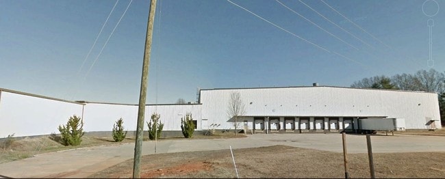
Property Record
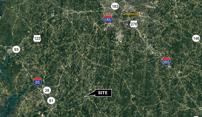
351 Kay St, Belton, SC 29627
Property Detail
351 Kay St
225-08-02-001
CP 030/00083 F 0200D 0200 PP 000/00000 CALVARY DR .93 AC
Warehouse
Anderson
B and X Area of moderate flood hazard, usually the area between the limits of the 100-year and 500-year floods.
South Carolina
0
10.40 AC
2025
Outlying Anderson Co
011401
Greenville/Spartanburg
54,666 SF
Greenville-Anderson-Greer, SC
NEARBY LISTINGS FOR SALE OR LEASE
-
-
View all Belton listings for sale on LoopNet.com
DEMOGRAPHICS near 351 Kay St
1 mile
3 mile
5 mile
2025 Total Population
2,914
9,245
18,297
2030 Population
3,078
9,744
19,292
Pop Growth 2025-2030
+ 5.63%
+ 5.40%
+ 5.44%
Average Age
41
41
42
2025 Total Households
1,230
3,799
7,206
HH Growth 2025-2030
+ 5.93%
+ 5.61%
+ 5.62%
Median Household Inc
$56,647
$55,280
$58,883
Avg Household Size
2.40
2.40
2.50
2025 Avg HH Vehicles
2.00
2.00
2.00
Median Home Value
$165,343
$161,529
$180,388
Median Year Built
1967
1974
1981
Nearby Places
Map Layers
Map Styles
 Street
 Aerial
Layers
 Traffic
 Biking
Places
Listings with unknown addresses are not visible on the map
- Restaurants
- Banks
- Shops
- Fitness
- Groceries
PUBLIC TRANSPORTATION
AIRPORT
Greenville Spartanburg International
Drive
Walk
Distance
Greenville Spartanburg International
54 min
37.6 mi
SALE & LEASE HISTORY
LISTING DATE
SALE/LEASE

Sep 25, 2016
For Lease
Sep 24, 2016
For Sale
Sep 23, 2016
For Sale
Oct 10, 2017
For Sale
Oct 03, 2018
For Lease
Oct 03, 2018
For Sale
Jul 29, 2020
For Lease
Aug 25, 2020
For Sale
Nearby Properties
Address
Land Use
TOTAL SIZE
Lot Size
Zoning
Address
Land Use
TOTAL SIZE
Lot Size
Zoning
230,048 SF
16.62 AC
Address
Land Use
TOTAL SIZE
Lot Size
Zoning
53,387 SF
2.57 AC
Address
Land Use
TOTAL SIZE
Lot Size
Zoning
696 SF
4.57 AC
Address
Land Use
TOTAL SIZE
Lot Size
Zoning
720 SF
23.35 AC
Address
Land Use
TOTAL SIZE
Lot Size
Zoning
8,425 SF
1.37 AC
Address
Land Use
TOTAL SIZE
Lot Size
Zoning
59,545 SF
15.42 AC
Address
Land Use
TOTAL SIZE
Lot Size
Zoning
6,722 SF
5.02 AC
Address
Land Use
TOTAL SIZE
Lot Size
Zoning
12,276 SF
1.97 AC
Address
Land Use
TOTAL SIZE
Lot Size
Zoning
720 SF
15.48 AC
Address
Land Use
TOTAL SIZE
Lot Size
Zoning
158,791 SF
54.55 AC
Address
Land Use
TOTAL SIZE
Lot Size
Zoning
6,231 SF
4.05 AC
Address
Land Use
TOTAL SIZE
Lot Size
Zoning
8,312 SF
7.50 AC
Address
Land Use
TOTAL SIZE
Lot Size
Zoning
2,070 SF
2.50 AC
Address
Land Use
TOTAL SIZE
Lot Size
Zoning
2,905 SF
1.13 AC
Address
Land Use
TOTAL SIZE
Lot Size
Zoning
8,988 SF
1.62 AC
Address
Land Use
TOTAL SIZE
Lot Size
Zoning
2,347 SF
1.38 AC
Address
Land Use
TOTAL SIZE
Lot Size
Zoning
59.40 AC
Address
Land Use
TOTAL SIZE
Lot Size
Zoning
50,849 SF
7.07 AC
Address
Land Use
TOTAL SIZE
Lot Size
Zoning
2,482 SF
5.93 AC
Address
Land Use
TOTAL SIZE
Lot Size
Zoning
2,619 SF
1.03 AC
Address
Land Use
TOTAL SIZE
Lot Size
Zoning
3,421 SF
1.18 AC
Address
Land Use
TOTAL SIZE
Lot Size
Zoning
42,248 SF
2.22 AC
Address
Land Use
TOTAL SIZE
Lot Size
Zoning
2,774 SF
2.12 AC
Address
Land Use
TOTAL SIZE
Lot Size
Zoning
2,877 SF
1.17 AC
Address
Land Use
TOTAL SIZE
Lot Size
Zoning
14,970 SF
3.86 AC
Address
Land Use
TOTAL SIZE
Lot Size
Zoning
9,760 SF
2.92 AC
Address
Land Use
TOTAL SIZE
Lot Size
Zoning
7,723 SF
12.98 AC
Address
Land Use
TOTAL SIZE
Lot Size
Zoning
519 SF
14.49 AC
The World's #1 Commercial Real Estate Marketplace
Connect with us
© 2026 CoStar Group
The information above has been obtained from sources believed reliable. While we do not doubt its accuracy we have not verified it and make no guarantee, warranty or representation about it. It is your responsibility to independently confirm its accuracy and completeness. Any projections, opinions, assumptions, or estimates used are for example only and do not represent the current or future performance of the property. The value of this transaction to you depends on tax and other factors which should be evaluated by your tax, financial, and legal advisors. You and your advisors should conduct a careful, independent investigation of the property to determine to your satisfaction the suitability of the property for your needs.