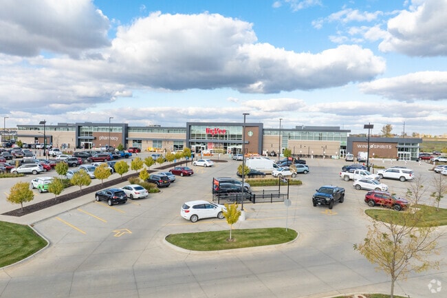
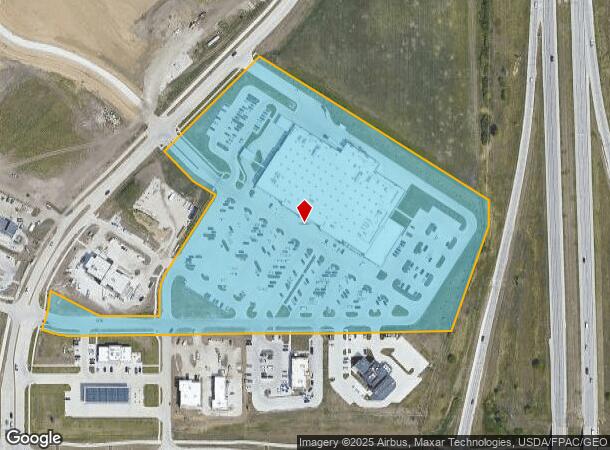
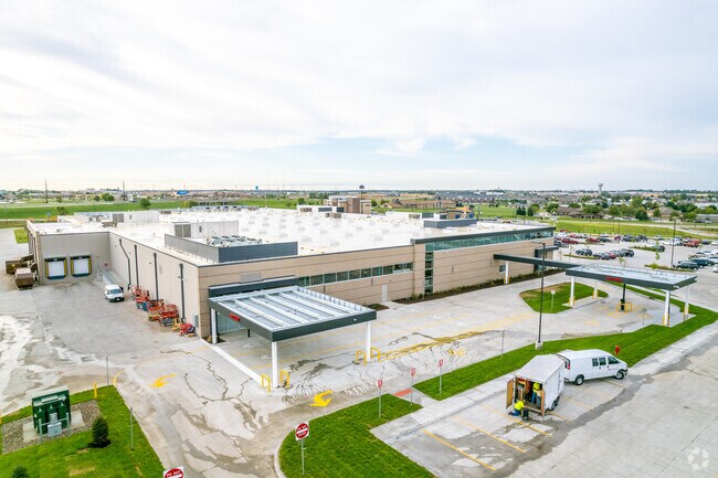
Property Record
351 Ne Gateway Dr, Grimes, IA 50111
NEARBY LISTINGS FOR SALE OR LEASE
Property Detail
351 Ne Gateway Dr
Des Moines
Hope Commercial Plat 3
Des Moines-West Des Moines, IA
LOT 3 HOPE COMMERCIAL PLAT 3
311/00305-730-514
Polk
Storebuilding
Iowa
0
3
2025
13 AC
011303
Western Suburbs
91,733 SF
DEMOGRAPHICS near 351 Ne Gateway Dr
1 Mile
3 Mile
5 Mile
2024 Total Population
9,257
30,957
73,864
2029 Population
9,940
32,531
78,840
Pop Growth 2024-2029
+ 7.38%
+ 5.08%
+ 6.74%
Average Age
34
36
38
2024 Total Households
3,508
11,408
27,885
HH Growth 2024-2029
+ 7.55%
+ 5.25%
+ 6.82%
Median Household Inc
$102,238
$105,219
$104,745
Avg Household Size
2.60
2.70
2.60
2024 Avg HH Vehicles
2.00
2.00
2.00
Median Home Value
$291,493
$299,695
$293,985
Median Year Built
2010
2007
2001
Nearby Places
Map Layers
Map Styles
 Street
 Aerial
- Restaurants
- Banks
- Shops
- Fitness
- Groceries
PUBLIC TRANSPORTATION
AIRPORT
Des Moines International
DRIVE
WALK
Distance
Des Moines International
30 min
17.2 mi
Freight Ports
Port Milwaukee
DRIVE
WALK
Distance
Port Milwaukee
425 min
381.5 mi
Nearby Properties
Address
Land Use
TOTAL SIZE
Lot Size
Zoning
Address
Land Use
TOTAL SIZE
Lot Size
Zoning
486,792 SF
38.70 AC
PC
Address
Land Use
TOTAL SIZE
Lot Size
Zoning
330,704 SF
15.86 AC
Address
Land Use
TOTAL SIZE
Lot Size
Zoning
386,976 SF
30 AC
Address
Land Use
TOTAL SIZE
Lot Size
Zoning
59,496 SF
9.34 AC
Address
Land Use
TOTAL SIZE
Lot Size
Zoning
197,658 SF
15.91 AC
Address
Land Use
TOTAL SIZE
Lot Size
Zoning
184,658 SF
14.61 AC
Address
Land Use
TOTAL SIZE
Lot Size
Zoning
300,000 SF
17.51 AC
Address
Land Use
TOTAL SIZE
Lot Size
Zoning
270,000 SF
19.10 AC
Address
Land Use
TOTAL SIZE
Lot Size
Zoning
133,256 SF
15.93 AC
Address
Land Use
TOTAL SIZE
Lot Size
Zoning
260,000 SF
14.32 AC
Address
Land Use
TOTAL SIZE
Lot Size
Zoning
269,700 SF
16.53 AC
Address
Land Use
TOTAL SIZE
Lot Size
Zoning
260,000 SF
18.45 AC
Address
Land Use
TOTAL SIZE
Lot Size
Zoning
235,422 SF
13.39 AC
Address
Land Use
TOTAL SIZE
Lot Size
Zoning
250,000 SF
13.93 AC
Address
Land Use
TOTAL SIZE
Lot Size
Zoning
245,520 SF
19.33 AC
Address
Land Use
TOTAL SIZE
Lot Size
Zoning
77.75 AC
Address
Land Use
TOTAL SIZE
Lot Size
Zoning
212,500 SF
10.20 AC
Address
Land Use
TOTAL SIZE
Lot Size
Zoning
127,869 SF
6.70 AC
Address
Land Use
TOTAL SIZE
Lot Size
Zoning
35.81 AC
Address
Land Use
TOTAL SIZE
Lot Size
Zoning
219,950 SF
22.57 AC
Address
Land Use
TOTAL SIZE
Lot Size
Zoning
200,000 SF
14.57 AC
Address
Land Use
TOTAL SIZE
Lot Size
Zoning
181,984 SF
16.42 AC
Address
Land Use
TOTAL SIZE
Lot Size
Zoning
187,816 SF
21.51 AC
M-2
Address
Land Use
TOTAL SIZE
Lot Size
Zoning
84,315 SF
20.59 AC
M2
Address
Land Use
TOTAL SIZE
Lot Size
Zoning
198,944 SF
8.61 AC
Address
Land Use
TOTAL SIZE
Lot Size
Zoning
197,966 SF
10.09 AC
Address
Land Use
TOTAL SIZE
Lot Size
Zoning
101,234 SF
7.49 AC
Address
Land Use
TOTAL SIZE
Lot Size
Zoning
144,545 SF
11.94 AC
Address
Land Use
TOTAL SIZE
Lot Size
Zoning
160,416 SF
23.78 AC
C-2
The World's #1 Commercial Real Estate Marketplace
Connect with us
© 2026 CoStar Group
The information above has been obtained from sources believed reliable. While we do not doubt its accuracy we have not verified it and make no guarantee, warranty or representation about it. It is your responsibility to independently confirm its accuracy and completeness. Any projections, opinions, assumptions, or estimates used are for example only and do not represent the current or future performance of the property. The value of this transaction to you depends on tax and other factors which should be evaluated by your tax, financial, and legal advisors. You and your advisors should conduct a careful, independent investigation of the property to determine to your satisfaction the suitability of the property for your needs.