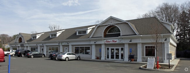
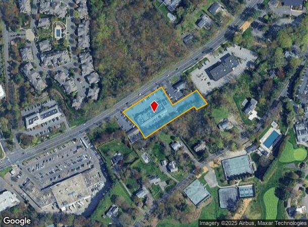
Property Record
351 Post Rd W, Westport, CT 06880
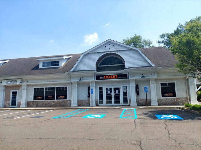

Current Lease Availabilities
NEARBY LISTINGS FOR SALE OR LEASE
Property Detail
351 Post Rd W
WPOR-000007B-000000-000036
Fairfield
Commercialbuilding
Connecticut
X
36-0
09001C0394F
1.45 AC
2025
Westport
2025
Westchester/So Connecticut
050200
Bridgeport-Stamford-Norwalk, CT
10,374 SF
DEMOGRAPHICS near 351 Post Rd W
1 Mile
3 Mile
5 Mile
2024 Total Population
8,446
70,976
131,885
2029 Population
8,488
71,136
131,971
Pop Growth 2024-2029
+ 0.50%
+ 0.23%
+ 0.07%
Average Age
43
41
41
2024 Total Households
3,419
28,338
50,166
HH Growth 2024-2029
+ 0.50%
+ 0.22%
+ 0.06%
Median Household Inc
$133,617
$110,122
$115,015
Avg Household Size
2.40
2.40
2.60
2024 Avg HH Vehicles
2.00
2.00
2.00
Median Home Value
$745,930
$620,577
$670,180
Median Year Built
1967
1966
1966
Nearby Places
- Restaurants
- Banks
- Shops
- Fitness
- Groceries
PUBLIC TRANSPORTATION
COMMUTER RAIL
Westport Station (New Haven Line - Metro-North Commuter Railroad Company (Metro-North))
DRIVE
WALK
Distance
Westport Station (New Haven Line - Metro-North Commuter Railroad Company (Metro-North))
5 min
1.8 mi
East Norwalk Station (New Haven Line - Metro-North Commuter Railroad Company (Metro-North))
DRIVE
WALK
Distance
East Norwalk Station (New Haven Line - Metro-North Commuter Railroad Company (Metro-North))
8 min
3.9 mi
AIRPORT
Westchester County
DRIVE
WALK
Distance
Westchester County
37 min
30.3 mi
Freight Ports
NY - Red Hook Container Terminal
DRIVE
WALK
Distance
NY - Red Hook Container Terminal
1 min
44.9 mi
Nearby Properties
Address
Land Use
TOTAL SIZE
Lot Size
Zoning
Address
Land Use
TOTAL SIZE
Lot Size
Zoning
4.49 AC
CBDB
Address
Land Use
TOTAL SIZE
Lot Size
Zoning
749,988 SF
4.52 AC
CBDB
Address
Land Use
TOTAL SIZE
Lot Size
Zoning
339,272 SF
4.07 AC
EO
Address
Land Use
TOTAL SIZE
Lot Size
Zoning
50.42 AC
DDD4
Address
Land Use
TOTAL SIZE
Lot Size
Zoning
6.80 AC
B2
Address
Land Use
TOTAL SIZE
Lot Size
Zoning
226,920 SF
24.75 AC
B
Address
Land Use
TOTAL SIZE
Lot Size
Zoning
4.44 AC
CBDB
Address
Land Use
TOTAL SIZE
Lot Size
Zoning
248,486 SF
6.57 AC
EO
Address
Land Use
TOTAL SIZE
Lot Size
Zoning
254,126 SF
3.33 AC
EO
Address
Land Use
TOTAL SIZE
Lot Size
Zoning
269,100 SF
38.37 AC
RI
Address
Land Use
TOTAL SIZE
Lot Size
Zoning
320,588 SF
3.22 AC
EO
Address
Land Use
TOTAL SIZE
Lot Size
Zoning
254,126 SF
3.06 AC
EO
Address
Land Use
TOTAL SIZE
Lot Size
Zoning
252,316 SF
Address
Land Use
TOTAL SIZE
Lot Size
Zoning
271,344 SF
2.36 AC
EO
Address
Land Use
TOTAL SIZE
Lot Size
Zoning
1.44 AC
BCD/H
Address
Land Use
TOTAL SIZE
Lot Size
Zoning
101,688 SF
5 AC
RI
Address
Land Use
TOTAL SIZE
Lot Size
Zoning
272.25 AC
AAA
Address
Land Use
TOTAL SIZE
Lot Size
Zoning
Address
Land Use
TOTAL SIZE
Lot Size
Zoning
13.46 AC
RB
Address
Land Use
TOTAL SIZE
Lot Size
Zoning
13.10 AC
RBD
Address
Land Use
TOTAL SIZE
Lot Size
Zoning
29.50 AC
DOSRD1
Address
Land Use
TOTAL SIZE
Lot Size
Zoning
108,119 SF
3.62 AC
I1
Address
Land Use
TOTAL SIZE
Lot Size
Zoning
175,791 SF
1.58 AC
CBDB
Address
Land Use
TOTAL SIZE
Lot Size
Zoning
23.15 AC
A
Address
Land Use
TOTAL SIZE
Lot Size
Zoning
12.30 AC
AA
Address
Land Use
TOTAL SIZE
Lot Size
Zoning
165,384 SF
18.78 AC
B
Address
Land Use
TOTAL SIZE
Lot Size
Zoning
3.40 AC
RPDD
Address
Land Use
TOTAL SIZE
Lot Size
Zoning
4.79 AC
EO
Address
Land Use
TOTAL SIZE
Lot Size
Zoning
248,782 SF
3.52 AC
EO
Address
Land Use
TOTAL SIZE
Lot Size
Zoning
168.95 AC
AAA_AA
The World's #1 Commercial Real Estate Marketplace
Connect with us
© 2025 CoStar Group
The information above has been obtained from sources believed reliable. While we do not doubt its accuracy we have not verified it and make no guarantee, warranty or representation about it. It is your responsibility to independently confirm its accuracy and completeness. Any projections, opinions, assumptions, or estimates used are for example only and do not represent the current or future performance of the property. The value of this transaction to you depends on tax and other factors which should be evaluated by your tax, financial, and legal advisors. You and your advisors should conduct a careful, independent investigation of the property to determine to your satisfaction the suitability of the property for your needs.