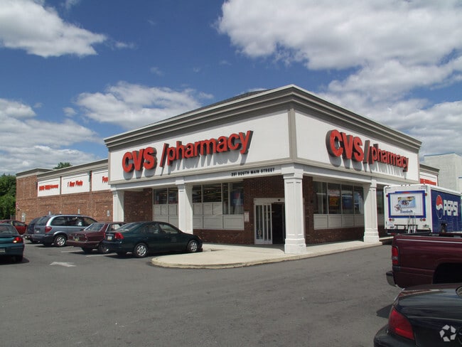
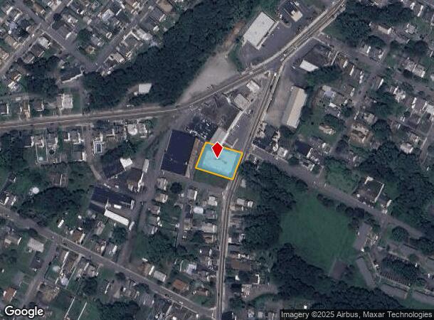
Property Record
351 S Main St, Duryea, PA 18642
NEARBY LISTINGS FOR SALE OR LEASE
Property Detail
351 S Main St
Scranton--Wilkes-Barre--Hazelton, PA
72-10-373-2-D1-D1-6 351 S MAIN ST
72-E11SE4-003-03A-000
Luzerne
Industrialacreage
Pennsylvania
X
3a
42079C0233F
0.39 AC
2025
I-81 Corridor
2025
Philadelphia
210500
DEMOGRAPHICS near 351 S Main St
1 Mile
3 Mile
5 Mile
2024 Total Population
24,670
87,569
119,082
2029 Population
24,870
87,781
119,040
Pop Growth 2024-2029
+ 0.81%
+ 0.24%
(0.04%)
Average Age
38
40
41
2024 Total Households
9,867
36,500
50,497
HH Growth 2024-2029
+ 0.94%
+ 0.22%
(0.09%)
Median Household Inc
$41,288
$49,243
$52,931
Avg Household Size
2.20
2.20
2.20
2024 Avg HH Vehicles
1.00
1.00
2.00
Median Home Value
$81,364
$97,405
$110,530
Median Year Built
1949
1949
1949
Nearby Places
Map Layers
Map Styles
 Street
 Aerial
- Restaurants
- Banks
- Shops
- Fitness
- Groceries
PUBLIC TRANSPORTATION
AIRPORT
Wilkes-Barre/Scranton International
DRIVE
WALK
Distance
Wilkes-Barre/Scranton International
13 min
5.7 mi
Freight Ports
Maher Terminal
DRIVE
WALK
Distance
Maher Terminal
158 min
125.8 mi
Nearby Properties
Address
Land Use
TOTAL SIZE
Lot Size
Zoning
Address
Land Use
TOTAL SIZE
Lot Size
Zoning
225.55 AC
Address
Land Use
TOTAL SIZE
Lot Size
Zoning
48.95 AC
Address
Land Use
TOTAL SIZE
Lot Size
Zoning
46.26 AC
Address
Land Use
TOTAL SIZE
Lot Size
Zoning
80.97 AC
Address
Land Use
TOTAL SIZE
Lot Size
Zoning
130.63 AC
Address
Land Use
TOTAL SIZE
Lot Size
Zoning
92.99 AC
Address
Land Use
TOTAL SIZE
Lot Size
Zoning
59.28 AC
Address
Land Use
TOTAL SIZE
Lot Size
Zoning
46.01 AC
Address
Land Use
TOTAL SIZE
Lot Size
Zoning
51.15 AC
Address
Land Use
TOTAL SIZE
Lot Size
Zoning
43.65 AC
Address
Land Use
TOTAL SIZE
Lot Size
Zoning
50.85 AC
Address
Land Use
TOTAL SIZE
Lot Size
Zoning
24.33 AC
Address
Land Use
TOTAL SIZE
Lot Size
Zoning
34.07 AC
Address
Land Use
TOTAL SIZE
Lot Size
Zoning
13.79 AC
Address
Land Use
TOTAL SIZE
Lot Size
Zoning
15.60 AC
Address
Land Use
TOTAL SIZE
Lot Size
Zoning
24.30 AC
Address
Land Use
TOTAL SIZE
Lot Size
Zoning
8.61 AC
Address
Land Use
TOTAL SIZE
Lot Size
Zoning
21.31 AC
Address
Land Use
TOTAL SIZE
Lot Size
Zoning
5.93 AC
Address
Land Use
TOTAL SIZE
Lot Size
Zoning
13.59 AC
Address
Land Use
TOTAL SIZE
Lot Size
Zoning
14.35 AC
Address
Land Use
TOTAL SIZE
Lot Size
Zoning
4.56 AC
Address
Land Use
TOTAL SIZE
Lot Size
Zoning
9.70 AC
Address
Land Use
TOTAL SIZE
Lot Size
Zoning
Address
Land Use
TOTAL SIZE
Lot Size
Zoning
25.05 AC
Address
Land Use
TOTAL SIZE
Lot Size
Zoning
24.44 AC
Address
Land Use
TOTAL SIZE
Lot Size
Zoning
17.29 AC
Address
Land Use
TOTAL SIZE
Lot Size
Zoning
20.95 AC
The World's #1 Commercial Real Estate Marketplace
Connect with us
© 2025 CoStar Group
The information above has been obtained from sources believed reliable. While we do not doubt its accuracy we have not verified it and make no guarantee, warranty or representation about it. It is your responsibility to independently confirm its accuracy and completeness. Any projections, opinions, assumptions, or estimates used are for example only and do not represent the current or future performance of the property. The value of this transaction to you depends on tax and other factors which should be evaluated by your tax, financial, and legal advisors. You and your advisors should conduct a careful, independent investigation of the property to determine to your satisfaction the suitability of the property for your needs.