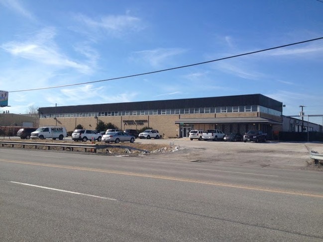
Property Record
3510 Calumet Ave, Hammond, IN 46320
NEARBY LISTINGS FOR SALE OR LEASE
Property Detail
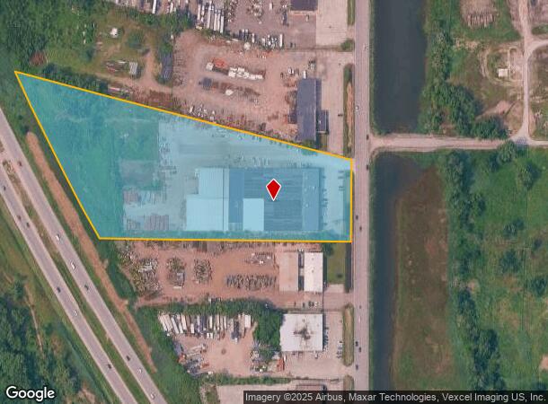
3510 Calumet Ave
45-02-24-277-001.000-023
PT. NE PT. BESSEMER PARK VAC. LYG ELY OF ELY LINE TOLL RD. S.24 T.37 R.10 8.0 07 AC
Warehouse
Lake
AE
Indiana
18089C0019E
1
2024
8 AC
2025
Indiana
020300
Chicago
92,633 SF
Chicago-Naperville-Elgin, IL-IN-WI
DEMOGRAPHICS near 3510 Calumet Ave
1 Mile
3 Mile
5 Mile
2024 Total Population
3,906
70,286
179,209
2029 Population
3,891
69,491
175,691
Pop Growth 2024-2029
(0.38%)
(1.13%)
(1.96%)
Average Age
38
38
38
2024 Total Households
1,404
25,620
66,394
HH Growth 2024-2029
(0.57%)
(1.30%)
(2.14%)
Median Household Inc
$57,387
$49,320
$47,825
Avg Household Size
2.70
2.60
2.60
2024 Avg HH Vehicles
2.00
2.00
2.00
Median Home Value
$120,391
$128,993
$132,157
Median Year Built
1954
1948
1952
Nearby Places
Map Layers
Map Styles
 Street
 Aerial
- Restaurants
- Banks
- Shops
- Fitness
- Groceries
PUBLIC TRANSPORTATION
COMMUTER RAIL
Hammond Station (South Shore Line - Northern Indiana Commuter Transportation District (South Shore Line))
DRIVE
WALK
Distance
Hammond Station (South Shore Line - Northern Indiana Commuter Transportation District (South Shore Line))
4 min
1.8 mi
DRIVE
WALK
Distance
7 min
3.1 mi
AIRPORT
Chicago Midway International
DRIVE
WALK
Distance
Chicago Midway International
34 min
19.0 mi
Chicago O'Hare International
DRIVE
WALK
Distance
Chicago O'Hare International
79 min
39.7 mi
Nearby Properties
Address
Land Use
TOTAL SIZE
Lot Size
Zoning
Address
Land Use
TOTAL SIZE
Lot Size
Zoning
27,934 SF
37.50 AC
Address
Land Use
TOTAL SIZE
Lot Size
Zoning
399,000 SF
23.92 AC
Address
Land Use
TOTAL SIZE
Lot Size
Zoning
119,200 SF
9.87 AC
Address
Land Use
TOTAL SIZE
Lot Size
Zoning
82,736 SF
0.37 AC
Address
Land Use
TOTAL SIZE
Lot Size
Zoning
144,256 SF
2.91 AC
R3
Address
Land Use
TOTAL SIZE
Lot Size
Zoning
241,800 SF
14.30 AC
Address
Land Use
TOTAL SIZE
Lot Size
Zoning
221,190 SF
109.74 AC
Address
Land Use
TOTAL SIZE
Lot Size
Zoning
443,065 SF
36.69 AC
Address
Land Use
TOTAL SIZE
Lot Size
Zoning
115,612 SF
4.20 AC
Address
Land Use
TOTAL SIZE
Lot Size
Zoning
99,042 SF
255 AC
Address
Land Use
TOTAL SIZE
Lot Size
Zoning
244,773 SF
65.01 AC
Address
Land Use
TOTAL SIZE
Lot Size
Zoning
298,373 SF
21.23 AC
Address
Land Use
TOTAL SIZE
Lot Size
Zoning
6,139 SF
78.90 AC
Address
Land Use
TOTAL SIZE
Lot Size
Zoning
130,002 SF
18.27 AC
Address
Land Use
TOTAL SIZE
Lot Size
Zoning
790,642 SF
37.20 AC
Address
Land Use
TOTAL SIZE
Lot Size
Zoning
16,644 SF
52.10 AC
Address
Land Use
TOTAL SIZE
Lot Size
Zoning
484,604 SF
70.49 AC
Address
Land Use
TOTAL SIZE
Lot Size
Zoning
126,900 SF
75.99 AC
Address
Land Use
TOTAL SIZE
Lot Size
Zoning
292,953 SF
8.93 AC
Address
Land Use
TOTAL SIZE
Lot Size
Zoning
55,800 SF
7.25 AC
Address
Land Use
TOTAL SIZE
Lot Size
Zoning
118,120 SF
4.70 AC
Address
Land Use
TOTAL SIZE
Lot Size
Zoning
68,885 SF
5.93 AC
Address
Land Use
TOTAL SIZE
Lot Size
Zoning
8,400 SF
65.94 AC
PMD 6
Address
Land Use
TOTAL SIZE
Lot Size
Zoning
678,912 SF
29.68 AC
Address
Land Use
TOTAL SIZE
Lot Size
Zoning
91,644 SF
29.28 AC
Address
Land Use
TOTAL SIZE
Lot Size
Zoning
115,509 SF
5.95 AC
Address
Land Use
TOTAL SIZE
Lot Size
Zoning
29.25 AC
PMD 6
Address
Land Use
TOTAL SIZE
Lot Size
Zoning
261,928 SF
12.74 AC
Address
Land Use
TOTAL SIZE
Lot Size
Zoning
129,650 SF
12.16 AC
Address
Land Use
TOTAL SIZE
Lot Size
Zoning
219,409 SF
89.21 AC
The World's #1 Commercial Real Estate Marketplace
Connect with us
© 2026 CoStar Group
The information above has been obtained from sources believed reliable. While we do not doubt its accuracy we have not verified it and make no guarantee, warranty or representation about it. It is your responsibility to independently confirm its accuracy and completeness. Any projections, opinions, assumptions, or estimates used are for example only and do not represent the current or future performance of the property. The value of this transaction to you depends on tax and other factors which should be evaluated by your tax, financial, and legal advisors. You and your advisors should conduct a careful, independent investigation of the property to determine to your satisfaction the suitability of the property for your needs.