Property Record
3510 Highway 59 N, Shepherd, TX 77371


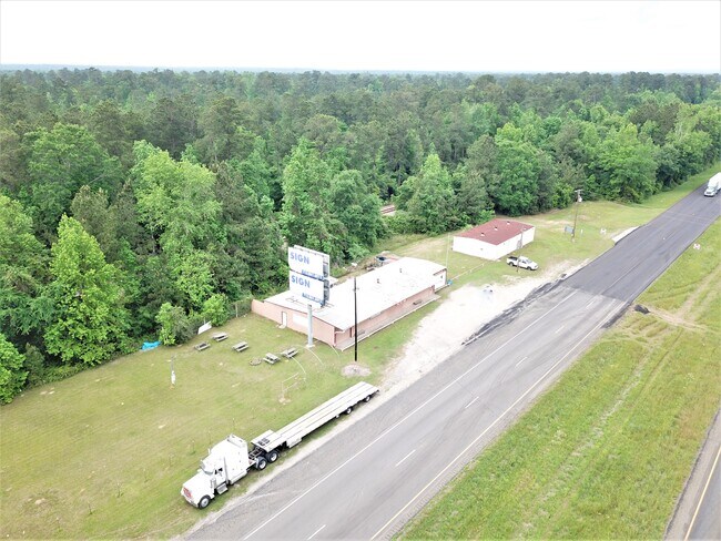
Property Detail
3510 Highway 59 N
41606
A020 WILLIAM HARDIN, TRACT 61, 64 & 65, ACRES 3.499
Commercialnec
San Jacinto
B and X Area of moderate flood hazard, usually the area between the limits of the 100-year and 500-year floods.
Texas
2024
3.50 AC
2025
San Jacinto County
200103
Houston
4,936 SF
Houston-Pasadena-The Woodlands, TX
NEARBY LISTINGS FOR SALE OR LEASE
DEMOGRAPHICS near 3510 Highway 59 N
1 mile
3 mile
5 mile
2025 Total Population
109
2,816
5,734
2030 Population
115
2,964
6,052
Pop Growth 2025-2030
+ 5.50%
+ 5.26%
+ 5.55%
Average Age
40
39
39
2025 Total Households
38
986
2,009
HH Growth 2025-2030
+ 5.26%
+ 4.97%
+ 5.28%
Median Household Inc
$78,125
$61,875
$68,357
Avg Household Size
2.80
2.80
2.80
2025 Avg HH Vehicles
2.00
2.00
2.00
Median Home Value
$161,538
$171,428
$159,013
Median Year Built
1982
1986
1990
Nearby Places
Map Layers
Map Styles
 Street
 Aerial
Layers
 Traffic
 Biking
Places
Listings with unknown addresses are not visible on the map
- Restaurants
- Banks
- Shops
- Fitness
- Groceries
SALE & LEASE HISTORY
LISTING DATE
SALE/LEASE

Nov 19, 2018
For Sale
Feb 21, 2020
For Sale
Nearby Properties
Address
Land Use
TOTAL SIZE
Lot Size
Zoning
Address
Land Use
TOTAL SIZE
Lot Size
Zoning
128,569 SF
27.47 AC
Address
Land Use
TOTAL SIZE
Lot Size
Zoning
75,786 SF
11.40 AC
Address
Land Use
TOTAL SIZE
Lot Size
Zoning
77,141 SF
7.07 AC
Address
Land Use
TOTAL SIZE
Lot Size
Zoning
23,748 SF
0.61 AC
Address
Land Use
TOTAL SIZE
Lot Size
Zoning
22,992 SF
2.07 AC
Address
Land Use
TOTAL SIZE
Lot Size
Zoning
8,860 SF
11.79 AC
Address
Land Use
TOTAL SIZE
Lot Size
Zoning
46,800 SF
10 AC
Address
Land Use
TOTAL SIZE
Lot Size
Zoning
28,656 SF
15.71 AC
Address
Land Use
TOTAL SIZE
Lot Size
Zoning
8,325 SF
2.11 AC
Address
Land Use
TOTAL SIZE
Lot Size
Zoning
40,656 SF
3.81 AC
Address
Land Use
TOTAL SIZE
Lot Size
Zoning
14,036 SF
66.04 AC
Address
Land Use
TOTAL SIZE
Lot Size
Zoning
18,644 SF
1.15 AC
Address
Land Use
TOTAL SIZE
Lot Size
Zoning
8,396 SF
26.80 AC
Address
Land Use
TOTAL SIZE
Lot Size
Zoning
6,112 SF
9.66 AC
Address
Land Use
TOTAL SIZE
Lot Size
Zoning
8,445 SF
1.61 AC
Address
Land Use
TOTAL SIZE
Lot Size
Zoning
9,388 SF
8 AC
Address
Land Use
TOTAL SIZE
Lot Size
Zoning
6,900 SF
15.75 AC
Address
Land Use
TOTAL SIZE
Lot Size
Zoning
3,500 SF
1.33 AC
Address
Land Use
TOTAL SIZE
Lot Size
Zoning
8,691 SF
1.30 AC
Address
Land Use
TOTAL SIZE
Lot Size
Zoning
6,018 SF
3.16 AC
Address
Land Use
TOTAL SIZE
Lot Size
Zoning
4,059 SF
25.35 AC
Address
Land Use
TOTAL SIZE
Lot Size
Zoning
5,420 SF
15 AC
Address
Land Use
TOTAL SIZE
Lot Size
Zoning
70.25 AC
Address
Land Use
TOTAL SIZE
Lot Size
Zoning
4,138 SF
57.15 AC
Address
Land Use
TOTAL SIZE
Lot Size
Zoning
2,862 SF
2.21 AC
Address
Land Use
TOTAL SIZE
Lot Size
Zoning
5,408 SF
55.67 AC
Address
Land Use
TOTAL SIZE
Lot Size
Zoning
4,290 SF
91.80 AC
Address
Land Use
TOTAL SIZE
Lot Size
Zoning
8,208 SF
0.49 AC
Address
Land Use
TOTAL SIZE
Lot Size
Zoning
4,680 SF
0.95 AC
Address
Land Use
TOTAL SIZE
Lot Size
Zoning
6,500 SF
1.78 AC
The World's #1 Commercial Real Estate Marketplace
Connect with us
© 2026 CoStar Group
The information above has been obtained from sources believed reliable. While we do not doubt its accuracy we have not verified it and make no guarantee, warranty or representation about it. It is your responsibility to independently confirm its accuracy and completeness. Any projections, opinions, assumptions, or estimates used are for example only and do not represent the current or future performance of the property. The value of this transaction to you depends on tax and other factors which should be evaluated by your tax, financial, and legal advisors. You and your advisors should conduct a careful, independent investigation of the property to determine to your satisfaction the suitability of the property for your needs.