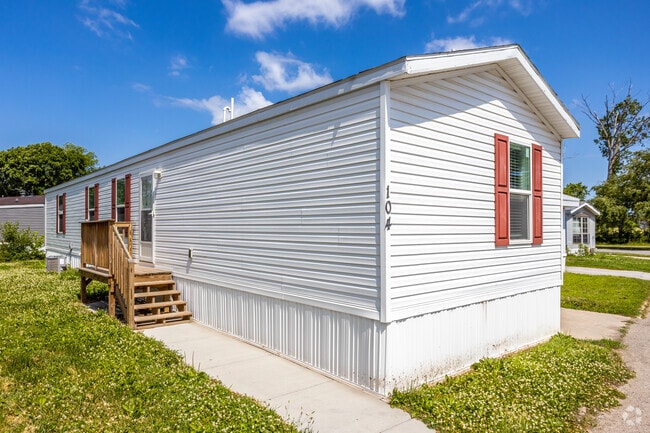
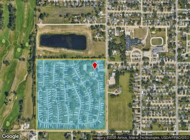
Property Record
3510 N 9Th St, Carter Lake, IA 51510
NEARBY LISTINGS FOR SALE OR LEASE
Property Detail
3510 N 9Th St
Omaha-Council Bluffs, NE-IA
Aud Sub
7544-20-226-001
CARTER LAKE-AUD SUB 20-75-44 LTS 1 THRU 3 & PT N1/2 NE BEING VAC RR ROW & 17-75-44 PT S1/2 SE BEING~VAC RR ROW & ALL VAC 5TH ST ADJ COMM NE COR SECT 20 TH W30' S1291.38' W1319.25' N1341.38' E1319.25'~S50' TO POB
Mobilehomepark
Pottawattamie
X
Iowa
31055C0241H
1-3
2025
39.68 AC
2025
Crater Lake
021200
Omaha/Council Bluffs
DEMOGRAPHICS near 3510 N 9Th St
1 Mile
3 Mile
5 Mile
2024 Total Population
5,470
77,013
213,894
2029 Population
5,465
78,691
217,219
Pop Growth 2024-2029
(0.09%)
+ 2.18%
+ 1.55%
Average Age
39
36
37
2024 Total Households
1,589
30,529
85,839
HH Growth 2024-2029
(0.50%)
+ 2.40%
+ 1.71%
Median Household Inc
$65,272
$43,032
$48,463
Avg Household Size
2.60
2.20
2.30
2024 Avg HH Vehicles
2.00
1.00
2.00
Median Home Value
$203,755
$129,992
$152,684
Median Year Built
1970
1955
1952
Nearby Places
Map Layers
Map Styles
 Street
 Aerial
- Restaurants
- Banks
- Shops
- Fitness
- Groceries
PUBLIC TRANSPORTATION
COMMUTER RAIL
DRIVE
WALK
Distance
9 min
3.6 mi
DRIVE
WALK
Distance
10 min
3.9 mi
AIRPORT
Eppley Airfield
DRIVE
WALK
Distance
Eppley Airfield
7 min
2.2 mi
Nearby Properties
Address
Land Use
TOTAL SIZE
Lot Size
Zoning
Address
Land Use
TOTAL SIZE
Lot Size
Zoning
1,068,760 SF
1.72 AC
Address
Land Use
TOTAL SIZE
Lot Size
Zoning
1,318,852 SF
8.77 AC
Address
Land Use
TOTAL SIZE
Lot Size
Zoning
603,518 SF
5.55 AC
CBD
Address
Land Use
TOTAL SIZE
Lot Size
Zoning
534,110 SF
4.35 AC
Address
Land Use
TOTAL SIZE
Lot Size
Zoning
30.39 AC
P-C
Address
Land Use
TOTAL SIZE
Lot Size
Zoning
362,402 SF
1.94 AC
Address
Land Use
TOTAL SIZE
Lot Size
Zoning
318,811 SF
11.51 AC
Address
Land Use
TOTAL SIZE
Lot Size
Zoning
254,306 SF
0.82 AC
Address
Land Use
TOTAL SIZE
Lot Size
Zoning
426,416 SF
1.55 AC
Address
Land Use
TOTAL SIZE
Lot Size
Zoning
378,420 SF
0.72 AC
Address
Land Use
TOTAL SIZE
Lot Size
Zoning
276,622 SF
3.90 AC
Address
Land Use
TOTAL SIZE
Lot Size
Zoning
189,720 SF
1.22 AC
CBD
Address
Land Use
TOTAL SIZE
Lot Size
Zoning
346,816 SF
0.80 AC
Address
Land Use
TOTAL SIZE
Lot Size
Zoning
318,392 SF
7.77 AC
Address
Land Use
TOTAL SIZE
Lot Size
Zoning
4.22 AC
R-4
Address
Land Use
TOTAL SIZE
Lot Size
Zoning
319,440 SF
3.05 AC
Address
Land Use
TOTAL SIZE
Lot Size
Zoning
335,431 SF
0.79 AC
Address
Land Use
TOTAL SIZE
Lot Size
Zoning
10.91 AC
R-3
Address
Land Use
TOTAL SIZE
Lot Size
Zoning
149,737 SF
1.93 AC
Address
Land Use
TOTAL SIZE
Lot Size
Zoning
274,024 SF
1.46 AC
Address
Land Use
TOTAL SIZE
Lot Size
Zoning
254,548 SF
1.67 AC
Address
Land Use
TOTAL SIZE
Lot Size
Zoning
162,765 SF
0.42 AC
CBD
Address
Land Use
TOTAL SIZE
Lot Size
Zoning
200,501 SF
1.78 AC
DS
Address
Land Use
TOTAL SIZE
Lot Size
Zoning
281,014 SF
3.68 AC
Address
Land Use
TOTAL SIZE
Lot Size
Zoning
200,580 SF
3.22 AC
Address
Land Use
TOTAL SIZE
Lot Size
Zoning
148,805 SF
0.92 AC
Address
Land Use
TOTAL SIZE
Lot Size
Zoning
11.10 AC
R-3
Address
Land Use
TOTAL SIZE
Lot Size
Zoning
14 AC
I-2
Address
Land Use
TOTAL SIZE
Lot Size
Zoning
189,690 SF
0.57 AC
The World's #1 Commercial Real Estate Marketplace
Connect with us
© 2026 CoStar Group
The information above has been obtained from sources believed reliable. While we do not doubt its accuracy we have not verified it and make no guarantee, warranty or representation about it. It is your responsibility to independently confirm its accuracy and completeness. Any projections, opinions, assumptions, or estimates used are for example only and do not represent the current or future performance of the property. The value of this transaction to you depends on tax and other factors which should be evaluated by your tax, financial, and legal advisors. You and your advisors should conduct a careful, independent investigation of the property to determine to your satisfaction the suitability of the property for your needs.