Property Record
1538 W 26Th St, Jacksonville, FL 32209

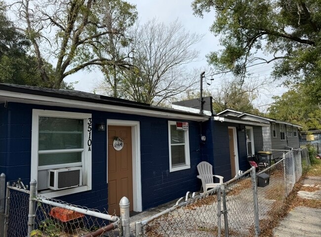
This Property Is For Sale
NEARBY LISTINGS FOR SALE OR LEASE
Property Detail
1538 W 26Th St
Jacksonville, FL
Moncrief Park
086898-0000
Duval
Sfr
Florida
X
0.09 AC
12031C0356H
Moncrief Park
930 SF
Jacksonville (Florida)
DEMOGRAPHICS near 1538 W 26Th St
1 Mile
3 Mile
5 Mile
2024 Total Population
17,593
103,489
203,675
2029 Population
19,074
111,438
218,467
Pop Growth 2024-2029
+ 8.42%
+ 7.68%
+ 7.26%
Average Age
38
39
39
2024 Total Households
6,976
41,019
84,536
HH Growth 2024-2029
+ 8.69%
+ 8.15%
+ 7.66%
Median Household Inc
$29,951
$34,339
$44,272
Avg Household Size
2.40
2.30
2.30
2024 Avg HH Vehicles
1.00
1.00
1.00
Median Home Value
$93,722
$125,061
$201,139
Median Year Built
1963
1961
1963
Nearby Places
Map Layers
Map Styles
 Street
 Aerial
- Restaurants
- Banks
- Shops
- Fitness
- Groceries
PUBLIC TRANSPORTATION
COMMUTER RAIL
Jacksonville (Silver Meteor - Amtrak, Silver Star - Amtrak)
DRIVE
WALK
Distance
Jacksonville (Silver Meteor - Amtrak, Silver Star - Amtrak)
6 min
3.1 mi
AIRPORT
Jacksonville International
DRIVE
WALK
Distance
Jacksonville International
21 min
13.0 mi
Freight Ports
Jacksonville Port
DRIVE
WALK
Distance
Jacksonville Port
8 min
3.9 mi
Nearby Properties
Address
Land Use
TOTAL SIZE
Lot Size
Zoning
Address
Land Use
TOTAL SIZE
Lot Size
Zoning
543,383 SF
7.87 AC
CCBD
Address
Land Use
TOTAL SIZE
Lot Size
Zoning
705,940 SF
25.12 AC
PBF-1
Address
Land Use
TOTAL SIZE
Lot Size
Zoning
165,408 SF
2.45 AC
CCBD
Address
Land Use
TOTAL SIZE
Lot Size
Zoning
407,122 SF
4.50 AC
CCBD
Address
Land Use
TOTAL SIZE
Lot Size
Zoning
521,850 SF
10.06 AC
CCBD
Address
Land Use
TOTAL SIZE
Lot Size
Zoning
187,278 SF
1.71 AC
CCBD
Address
Land Use
TOTAL SIZE
Lot Size
Zoning
127,732 SF
1.44 AC
CCBD
Address
Land Use
TOTAL SIZE
Lot Size
Zoning
313,472 SF
35.44 AC
CCBD
Address
Land Use
TOTAL SIZE
Lot Size
Zoning
355,967 SF
8.98 AC
PUD
Address
Land Use
TOTAL SIZE
Lot Size
Zoning
700,443 SF
8 AC
CCBD
Address
Land Use
TOTAL SIZE
Lot Size
Zoning
264,277 SF
2.07 AC
CCBD
Address
Land Use
TOTAL SIZE
Lot Size
Zoning
503,858 SF
1.32 AC
CCBD
Address
Land Use
TOTAL SIZE
Lot Size
Zoning
448,709 SF
2.97 AC
CCBD
Address
Land Use
TOTAL SIZE
Lot Size
Zoning
326,485 SF
1.56 AC
CCBD
Address
Land Use
TOTAL SIZE
Lot Size
Zoning
299,055 SF
18.93 AC
CCBD
Address
Land Use
TOTAL SIZE
Lot Size
Zoning
212,152 SF
8.17 AC
CCBD
Address
Land Use
TOTAL SIZE
Lot Size
Zoning
329,412 SF
1.75 AC
CCBD
Address
Land Use
TOTAL SIZE
Lot Size
Zoning
229,284 SF
7.24 AC
PUD
Address
Land Use
TOTAL SIZE
Lot Size
Zoning
213,439 SF
1.96 AC
CCBD
Address
Land Use
TOTAL SIZE
Lot Size
Zoning
165,035 SF
1.52 AC
CCBD
Address
Land Use
TOTAL SIZE
Lot Size
Zoning
163,471 SF
7.85 AC
PBF-2
Address
Land Use
TOTAL SIZE
Lot Size
Zoning
74,267 SF
1.04 AC
CCBD
Address
Land Use
TOTAL SIZE
Lot Size
Zoning
125,571 SF
5.97 AC
CCBD
Address
Land Use
TOTAL SIZE
Lot Size
Zoning
225,440 SF
4.68 AC
PUD
Address
Land Use
TOTAL SIZE
Lot Size
Zoning
23,689 SF
19.97 AC
CCBD
Address
Land Use
TOTAL SIZE
Lot Size
Zoning
255,405 SF
1.91 AC
PUD
Address
Land Use
TOTAL SIZE
Lot Size
Zoning
271,336 SF
1.25 AC
CCBD
Address
Land Use
TOTAL SIZE
Lot Size
Zoning
Address
Land Use
TOTAL SIZE
Lot Size
Zoning
276,156 SF
2.41 AC
CCG-S
Address
Land Use
TOTAL SIZE
Lot Size
Zoning
144,400 SF
10.32 AC
PBF-2
The World's #1 Commercial Real Estate Marketplace
Connect with us
© 2025 CoStar Group
The information above has been obtained from sources believed reliable. While we do not doubt its accuracy we have not verified it and make no guarantee, warranty or representation about it. It is your responsibility to independently confirm its accuracy and completeness. Any projections, opinions, assumptions, or estimates used are for example only and do not represent the current or future performance of the property. The value of this transaction to you depends on tax and other factors which should be evaluated by your tax, financial, and legal advisors. You and your advisors should conduct a careful, independent investigation of the property to determine to your satisfaction the suitability of the property for your needs.