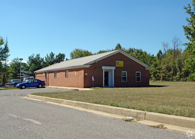
Property Record
3511 Spencerville Rd, Burtonsville, MD 20866

NEARBY LISTINGS FOR SALE OR LEASE
Property Detail
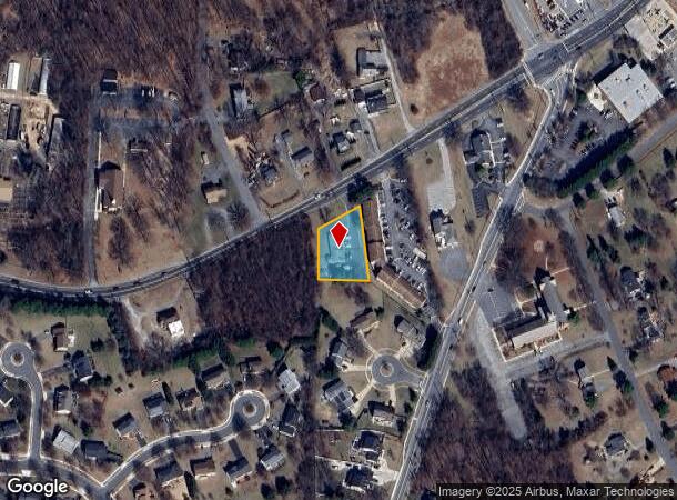
3511 Spencerville Rd
Washington-Arlington-Alexandria, DC-VA-MD-WV
Bealls Manor
05-01680036
PAR A BURTONSVILLE P OST OFFICE
Officebuilding
Montgomery
X
Maryland
24033C0030E
a
2024
0.53 AC
2025
North Silver Spring/Rt 29
701409
Washington, DC
2,533 SF
DEMOGRAPHICS near 3511 Spencerville Rd
1 Mile
3 Mile
5 Mile
2024 Total Population
7,738
52,403
178,799
2029 Population
7,608
51,571
176,891
Pop Growth 2024-2029
(1.68%)
(1.59%)
(1.07%)
Average Age
40
40
41
2024 Total Households
2,451
17,622
62,506
HH Growth 2024-2029
(1.92%)
(1.71%)
(1.20%)
Median Household Inc
$134,278
$109,415
$106,435
Avg Household Size
3.00
2.90
2.80
2024 Avg HH Vehicles
2.00
2.00
2.00
Median Home Value
$463,028
$488,370
$471,182
Median Year Built
1985
1983
1984
Nearby Places
Map Layers
Map Styles
 Street
 Aerial
- Restaurants
- Banks
- Shops
- Fitness
- Groceries
PUBLIC TRANSPORTATION
COMMUTER RAIL
Laurel (Camden Line - Maryland Area Regional Commuter Trains (The MARC))
DRIVE
WALK
Distance
Laurel (Camden Line - Maryland Area Regional Commuter Trains (The MARC))
13 min
6.1 mi
Muirkirk (Camden Line - Maryland Area Regional Commuter Trains (The MARC))
DRIVE
WALK
Distance
Muirkirk (Camden Line - Maryland Area Regional Commuter Trains (The MARC))
13 min
7.0 mi
AIRPORT
Ronald Reagan Washington Ntl
DRIVE
WALK
Distance
Ronald Reagan Washington Ntl
38 min
21.6 mi
Baltimore/Washington International Thurgood Marshall
DRIVE
WALK
Distance
Baltimore/Washington International Thurgood Marshall
31 min
21.9 mi
Washington Dulles International
DRIVE
WALK
Distance
Washington Dulles International
59 min
37.8 mi
Freight Ports
Port of Baltimore
DRIVE
WALK
Distance
Port of Baltimore
35 min
24.6 mi
Nearby Properties
Address
Land Use
TOTAL SIZE
Lot Size
Zoning
Address
Land Use
TOTAL SIZE
Lot Size
Zoning
218,406 SF
26.80 AC
LAUR
Address
Land Use
TOTAL SIZE
Lot Size
Zoning
531,312 SF
25.70 AC
R30
Address
Land Use
TOTAL SIZE
Lot Size
Zoning
559,944 SF
11.89 AC
IE
Address
Land Use
TOTAL SIZE
Lot Size
Zoning
482,799 SF
17.79 AC
R30
Address
Land Use
TOTAL SIZE
Lot Size
Zoning
166,410 SF
26.25 AC
CRT1.
Address
Land Use
TOTAL SIZE
Lot Size
Zoning
310,052 SF
9.63 AC
R20
Address
Land Use
TOTAL SIZE
Lot Size
Zoning
222,345 SF
14.21 AC
R30
Address
Land Use
TOTAL SIZE
Lot Size
Zoning
235,616 SF
12.81 AC
R30
Address
Land Use
TOTAL SIZE
Lot Size
Zoning
4,380 SF
17.89 AC
CRT22
Address
Land Use
TOTAL SIZE
Lot Size
Zoning
350,684 SF
36.50 AC
EOF1.
Address
Land Use
TOTAL SIZE
Lot Size
Zoning
456,896 SF
8.96 AC
R20
Address
Land Use
TOTAL SIZE
Lot Size
Zoning
239,072 SF
10.41 AC
R20
Address
Land Use
TOTAL SIZE
Lot Size
Zoning
177,712 SF
13.89 AC
GR1.5
Address
Land Use
TOTAL SIZE
Lot Size
Zoning
362,438 SF
39.95 AC
IE
Address
Land Use
TOTAL SIZE
Lot Size
Zoning
154,775 SF
33.38 AC
R200
Address
Land Use
TOTAL SIZE
Lot Size
Zoning
195,369 SF
9.72 AC
R20
Address
Land Use
TOTAL SIZE
Lot Size
Zoning
202,191 SF
7.70 AC
R30
Address
Land Use
TOTAL SIZE
Lot Size
Zoning
19.17 AC
IE
Address
Land Use
TOTAL SIZE
Lot Size
Zoning
242,468 SF
17.77 AC
R30
Address
Land Use
TOTAL SIZE
Lot Size
Zoning
115,000 SF
10.14 AC
RE1
Address
Land Use
TOTAL SIZE
Lot Size
Zoning
141,492 SF
7.96 AC
R20
Address
Land Use
TOTAL SIZE
Lot Size
Zoning
127,803 SF
2.91 AC
EOF07
Address
Land Use
TOTAL SIZE
Lot Size
Zoning
94,545 SF
30.85 AC
RC
Address
Land Use
TOTAL SIZE
Lot Size
Zoning
57,749 SF
4.98 AC
GR1.5
Address
Land Use
TOTAL SIZE
Lot Size
Zoning
92,227 SF
6.51 AC
R200
Address
Land Use
TOTAL SIZE
Lot Size
Zoning
95,600 SF
3.91 AC
IM2.5
Address
Land Use
TOTAL SIZE
Lot Size
Zoning
150,020 SF
19.11 AC
IE
Address
Land Use
TOTAL SIZE
Lot Size
Zoning
110,000 SF
2.11 AC
R30
Address
Land Use
TOTAL SIZE
Lot Size
Zoning
85,716 SF
11.90 AC
R30
Address
Land Use
TOTAL SIZE
Lot Size
Zoning
71,349 SF
6.66 AC
RC
The World's #1 Commercial Real Estate Marketplace
Connect with us
© 2025 CoStar Group
The information above has been obtained from sources believed reliable. While we do not doubt its accuracy we have not verified it and make no guarantee, warranty or representation about it. It is your responsibility to independently confirm its accuracy and completeness. Any projections, opinions, assumptions, or estimates used are for example only and do not represent the current or future performance of the property. The value of this transaction to you depends on tax and other factors which should be evaluated by your tax, financial, and legal advisors. You and your advisors should conduct a careful, independent investigation of the property to determine to your satisfaction the suitability of the property for your needs.