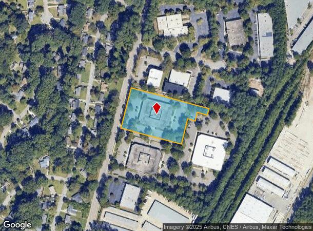
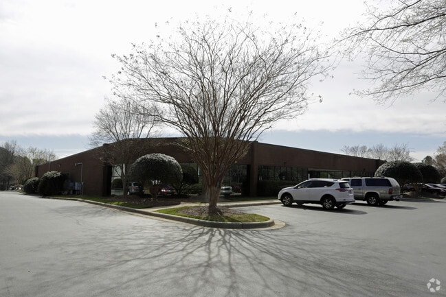
Property Record
3514 Bush St, Raleigh, NC 27609

Current Lease Availabilities
NEARBY LISTINGS FOR SALE OR LEASE
Property Detail
3514 Bush St
Raleigh, NC
Midtown Circle Sub
1715.11-57-0162-000
LO2E MIDTOWN CIRCLE SUB BM1997-02006
Officebuilding
Wake
X
North Carolina
3720171500K
2e
2025
2.46 AC
2025
Six Forks/Falls of Neuse
052701
Raleigh/Durham
29,485 SF
DEMOGRAPHICS near 3514 Bush St
1 Mile
3 Mile
5 Mile
2024 Total Population
8,309
94,595
255,389
2029 Population
9,002
102,703
278,035
Pop Growth 2024-2029
+ 8.34%
+ 8.57%
+ 8.87%
Average Age
37
39
38
2024 Total Households
3,925
41,485
109,822
HH Growth 2024-2029
+ 8.48%
+ 8.77%
+ 9.19%
Median Household Inc
$61,703
$76,127
$74,934
Avg Household Size
2.10
2.20
2.20
2024 Avg HH Vehicles
2.00
2.00
2.00
Median Home Value
$278,571
$362,519
$361,666
Median Year Built
1981
1983
1989
Nearby Places
- Restaurants
- Banks
- Shops
- Fitness
- Groceries
PUBLIC TRANSPORTATION
COMMUTER RAIL
Raleigh Union Station (Piedmont - North Carolina by Train (NC Train))
DRIVE
WALK
Distance
Raleigh Union Station (Piedmont - North Carolina by Train (NC Train))
12 min
5.2 mi
AIRPORT
Raleigh-Durham International
DRIVE
WALK
Distance
Raleigh-Durham International
26 min
16.0 mi
Nearby Properties
Address
Land Use
TOTAL SIZE
Lot Size
Zoning
Address
Land Use
TOTAL SIZE
Lot Size
Zoning
1,085,654 SF
16.87 AC
OX-5
Address
Land Use
TOTAL SIZE
Lot Size
Zoning
658,580 SF
3.30 AC
PD
Address
Land Use
TOTAL SIZE
Lot Size
Zoning
747,658 SF
11.12 AC
CX-12
Address
Land Use
TOTAL SIZE
Lot Size
Zoning
465,052 SF
2.65 AC
PD
Address
Land Use
TOTAL SIZE
Lot Size
Zoning
364,025 SF
2.19 AC
PD
Address
Land Use
TOTAL SIZE
Lot Size
Zoning
539,902 SF
1.28 AC
O&I-1
Address
Land Use
TOTAL SIZE
Lot Size
Zoning
303,238 SF
12.41 AC
PD
Address
Land Use
TOTAL SIZE
Lot Size
Zoning
354,131 SF
15.23 AC
RX-4
Address
Land Use
TOTAL SIZE
Lot Size
Zoning
544,122 SF
1.49 AC
PD
Address
Land Use
TOTAL SIZE
Lot Size
Zoning
355,931 SF
2.60 AC
PD
Address
Land Use
TOTAL SIZE
Lot Size
Zoning
284,958 SF
3.01 AC
PD
Address
Land Use
TOTAL SIZE
Lot Size
Zoning
366,905 SF
11.24 AC
OX-5
Address
Land Use
TOTAL SIZE
Lot Size
Zoning
289,301 SF
20.67 AC
OX-12
Address
Land Use
TOTAL SIZE
Lot Size
Zoning
282,285 SF
5.29 AC
PD
Address
Land Use
TOTAL SIZE
Lot Size
Zoning
319,136 SF
22.25 AC
OX-12
Address
Land Use
TOTAL SIZE
Lot Size
Zoning
403,782 SF
5.32 AC
RX-7
Address
Land Use
TOTAL SIZE
Lot Size
Zoning
349,485 SF
4.61 AC
OX-7
Address
Land Use
TOTAL SIZE
Lot Size
Zoning
193,990 SF
7.16 AC
RX-5
Address
Land Use
TOTAL SIZE
Lot Size
Zoning
186,221 SF
7.10 AC
RX-5
Address
Land Use
TOTAL SIZE
Lot Size
Zoning
373,187 SF
6.61 AC
PD
Address
Land Use
TOTAL SIZE
Lot Size
Zoning
358,520 SF
2.46 AC
CX-7
Address
Land Use
TOTAL SIZE
Lot Size
Zoning
325,835 SF
41.93 AC
R-4
Address
Land Use
TOTAL SIZE
Lot Size
Zoning
211,289 SF
6.87 AC
CX-5
Address
Land Use
TOTAL SIZE
Lot Size
Zoning
233,985 SF
8.60 AC
OX-5
Address
Land Use
TOTAL SIZE
Lot Size
Zoning
189,532 SF
1.53 AC
PD
Address
Land Use
TOTAL SIZE
Lot Size
Zoning
299,388 SF
13.83 AC
CX-4
Address
Land Use
TOTAL SIZE
Lot Size
Zoning
251,174 SF
13.98 AC
RX-3
Address
Land Use
TOTAL SIZE
Lot Size
Zoning
220,434 SF
41.81 AC
R-6
Address
Land Use
TOTAL SIZE
Lot Size
Zoning
144,364 SF
7.95 AC
OX-5
Address
Land Use
TOTAL SIZE
Lot Size
Zoning
280,614 SF
19.85 AC
RX-3
The World's #1 Commercial Real Estate Marketplace
Connect with us
© 2025 CoStar Group
The information above has been obtained from sources believed reliable. While we do not doubt its accuracy we have not verified it and make no guarantee, warranty or representation about it. It is your responsibility to independently confirm its accuracy and completeness. Any projections, opinions, assumptions, or estimates used are for example only and do not represent the current or future performance of the property. The value of this transaction to you depends on tax and other factors which should be evaluated by your tax, financial, and legal advisors. You and your advisors should conduct a careful, independent investigation of the property to determine to your satisfaction the suitability of the property for your needs.