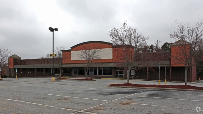
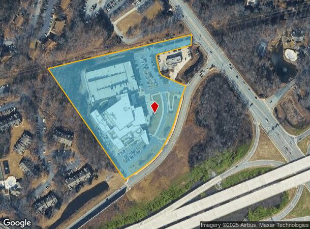
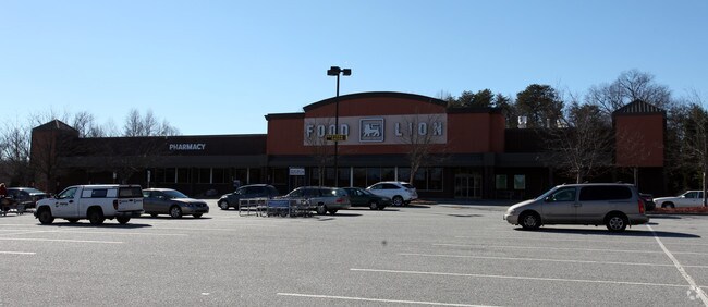
Property Record
3514 Drawbridge Pky, Greensboro, NC 27410
NEARBY LISTINGS FOR SALE OR LEASE
Property Detail
3514 Drawbridge Pky
Greensboro-High Point, NC
Battleground Square Lp
0080346
THE MOSES H CONE MEMORIAL HOSPITAL LO:1A
Governmentalpublicusegeneral
Guilford
X
North Carolina
3710784700J
1a
2024
9.41 AC
2025
NW Guilford County
016006
Greensboro/Winston-Salem
400 SF
DEMOGRAPHICS near 3514 Drawbridge Pky
1 Mile
3 Mile
5 Mile
2024 Total Population
8,646
45,608
117,561
2029 Population
8,625
45,252
116,678
Pop Growth 2024-2029
(0.24%)
(0.78%)
(0.75%)
Average Age
40
43
42
2024 Total Households
4,332
20,561
52,056
HH Growth 2024-2029
(0.14%)
(0.78%)
(0.74%)
Median Household Inc
$69,633
$82,282
$74,534
Avg Household Size
2.00
2.20
2.20
2024 Avg HH Vehicles
2.00
2.00
2.00
Median Home Value
$274,055
$264,366
$277,706
Median Year Built
1994
1989
1986
Nearby Places
Map Layers
Map Styles
 Street
 Aerial
- Restaurants
- Banks
- Shops
- Fitness
- Groceries
PUBLIC TRANSPORTATION
COMMUTER RAIL
Greensboro Station (Piedmont - North Carolina by Train (NC Train))
DRIVE
WALK
Distance
Greensboro Station (Piedmont - North Carolina by Train (NC Train))
15 min
6.9 mi
AIRPORT
Piedmont Triad International
DRIVE
WALK
Distance
Piedmont Triad International
15 min
7.2 mi
Nearby Properties
Address
Land Use
TOTAL SIZE
Lot Size
Zoning
Address
Land Use
TOTAL SIZE
Lot Size
Zoning
440,925 SF
72.55 AC
O
Address
Land Use
TOTAL SIZE
Lot Size
Zoning
472,566 SF
46.77 AC
RM-12
Address
Land Use
TOTAL SIZE
Lot Size
Zoning
106,706 SF
343.57 AC
PI
Address
Land Use
TOTAL SIZE
Lot Size
Zoning
309,598 SF
28.10 AC
RM-18
Address
Land Use
TOTAL SIZE
Lot Size
Zoning
317,844 SF
17.10 AC
PUD
Address
Land Use
TOTAL SIZE
Lot Size
Zoning
400,821 SF
30.06 AC
PUD
Address
Land Use
TOTAL SIZE
Lot Size
Zoning
227,063 SF
6.65 AC
C-H
Address
Land Use
TOTAL SIZE
Lot Size
Zoning
134,391 SF
19 AC
O
Address
Land Use
TOTAL SIZE
Lot Size
Zoning
466,399 SF
22.07 AC
RM-18
Address
Land Use
TOTAL SIZE
Lot Size
Zoning
222,661 SF
51.39 AC
R-3
Address
Land Use
TOTAL SIZE
Lot Size
Zoning
249,702 SF
15.39 AC
PUD
Address
Land Use
TOTAL SIZE
Lot Size
Zoning
214,228 SF
21.46 AC
C-H
Address
Land Use
TOTAL SIZE
Lot Size
Zoning
263,148 SF
32.18 AC
RM-8
Address
Land Use
TOTAL SIZE
Lot Size
Zoning
204,438 SF
12.06 AC
RM-18
Address
Land Use
TOTAL SIZE
Lot Size
Zoning
69,744 SF
100.01 AC
CD-O
Address
Land Use
TOTAL SIZE
Lot Size
Zoning
287,394 SF
7.47 AC
PUD
Address
Land Use
TOTAL SIZE
Lot Size
Zoning
223,272 SF
9.91 AC
RM-26
Address
Land Use
TOTAL SIZE
Lot Size
Zoning
302,048 SF
24.45 AC
RM-12
Address
Land Use
TOTAL SIZE
Lot Size
Zoning
206,820 SF
14.59 AC
C-H
Address
Land Use
TOTAL SIZE
Lot Size
Zoning
209,515 SF
30.04 AC
RM-8
Address
Land Use
TOTAL SIZE
Lot Size
Zoning
367,338 SF
28.02 AC
RM-12
Address
Land Use
TOTAL SIZE
Lot Size
Zoning
137,800 SF
11.64 AC
RM-12
Address
Land Use
TOTAL SIZE
Lot Size
Zoning
231,049 SF
30.76 AC
RM-8
Address
Land Use
TOTAL SIZE
Lot Size
Zoning
194,064 SF
22.83 AC
RM-12
Address
Land Use
TOTAL SIZE
Lot Size
Zoning
316,644 SF
22.31 AC
RM-12
Address
Land Use
TOTAL SIZE
Lot Size
Zoning
141,750 SF
38.97 AC
PI
Address
Land Use
TOTAL SIZE
Lot Size
Zoning
175,238 SF
21.85 AC
C-H
Address
Land Use
TOTAL SIZE
Lot Size
Zoning
237,518 SF
35.22 AC
RM-8
Address
Land Use
TOTAL SIZE
Lot Size
Zoning
99,412 SF
6.13 AC
C-M
The World's #1 Commercial Real Estate Marketplace
Connect with us
© 2026 CoStar Group
The information above has been obtained from sources believed reliable. While we do not doubt its accuracy we have not verified it and make no guarantee, warranty or representation about it. It is your responsibility to independently confirm its accuracy and completeness. Any projections, opinions, assumptions, or estimates used are for example only and do not represent the current or future performance of the property. The value of this transaction to you depends on tax and other factors which should be evaluated by your tax, financial, and legal advisors. You and your advisors should conduct a careful, independent investigation of the property to determine to your satisfaction the suitability of the property for your needs.